No, THANK YOU! Truly a honor to wear the 💜💛 while trying to continuing the greatness & legacies that came before me! Hope I made a few proud during my stint. 🙏🏾🫡👑
WEDNESDAY, June 17 will feature the potential for a few significant (EF2-EF3) tornadoes in central/northern Illinois and Indiana.
This map is a raw simulation from the HRRR model. It can and will change, but it gives a general idea – the overlap of storm fuel/spin will be sufficient to support a few significant tornadoes.
It's worth noting that, despite the overlapping ingredients, there's no guarantee storms will evolve as supercells and be able to fully take advantage of the volatile wind dynamics. Still, this is a concerning output.
We believe that, after a morning batch of downpours/storms, the atmosphere will reload very quickly. We're especially concerned about the warm front lifting north. Warm fronts tent to have extra low-level helicity, or twist, along them. That could lead to a focused corridor of rotating storm potential and tornado activity.
The warm front will lift into northern Indiana during the afternoon. It may not "feel" like tornado weather until the last minute as the warm front lifts in and introduces a warm, humid airmass.
I'm also a bit concerned about how close the surface low, replete with vorticity (spin), will pass near Chicago. That could bring the tornado risk nearer to the city.
TORNADO OUTBREAK LIKELY Wednesday again across the Corn Belt from northeastern Missouri through central Illinois into Indiana.
This is a very potent trough ejection and associated jet stream kinematics, with spring-like upper levels with June instability and moisture. Anomalous systems cause anomalous impacts, so we should brace for a high ceiling severe weather outbreak.
All hazards will be possible in this target area, including intense tornadoes, vigorous wind bag, and large destructive hail.
We will be activating storm chase mode for this event
Going to a battle between chasers that choose Western IL like we are or Eastern IL and IN where there is a good chance for something crazy to pop there by or past Sunset on the LLJ.
Basically outflow boundary and risky fast linear and a tight supercell chance or eastern IL and IN where better kinematics will be later and more of a huge tornado chance.
A significant severe weather outbreak will be possible Wednesday afternoon and evening for portions of IN, IL, IA, and MO. Storms should initiate during the mid-afternoon hours and move southeast. All hazards, including very large hail, strong tornadoes, and swaths of damaging winds are possible.
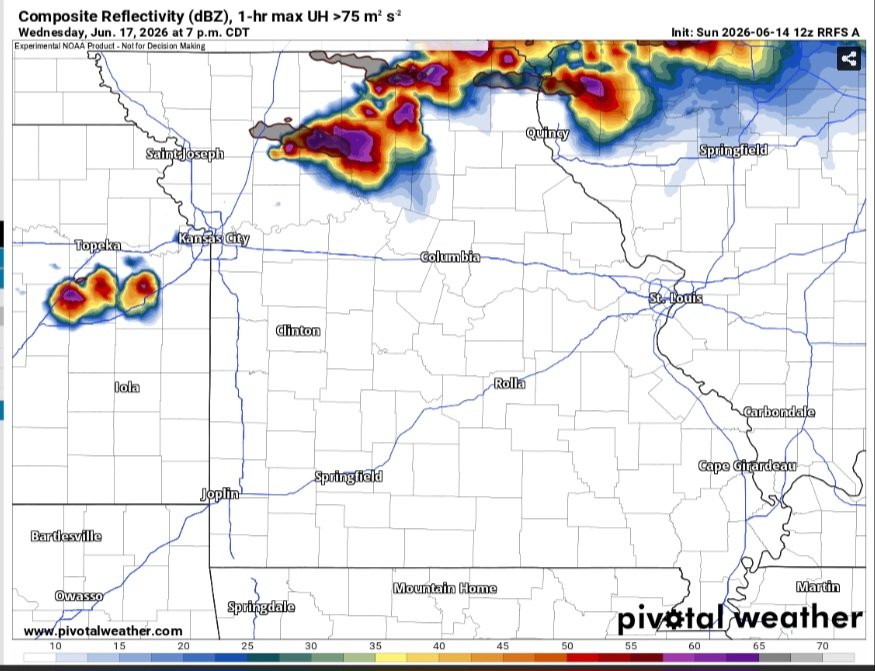
Most of these modeled supercells are north of the warm front (elevated), and the RRFS is trash with the environment, but still quite the look for Wednesday...
Wednesday is trending towards severe weather outbreak across Missouri, Iowa & Illinois with high probabilities for sig. severe hazards. Our models indicate a rare MDRT risk already at #DAY4, which means there is good agreement among members for extreme environment. #wxtwitter
SIGNIFICANT #TORNADO OUTBREAK possible Wednesday across the same areas - northern Missouri into central Illinois!
This is an incredibly strong polar jet stream for this time of year, and a crazy trough ejection is forecast to unleash on the Corn Belt Wednesday.
We are watching this setup like a Dominator hawk. Stay tuned