New drought monitor is out, & there's been improvement. Worst areas are slowly eroding away. More storms this week + potential for heavier rain next week in the Panhandle/N. FL should help further. (📷:left = latest monitor, right = change since last week. Green = improvement!)
🥵Summertime heat & humidity develops later this week into the weekend.
⚠️ Heat Index values are forecast to soar to the 104-108 degree range Saturday afternoon.
🌧️ Widely scattered showers/storms for north-central FL expected through mid-week increase area-wide into the weekend.
A widespread heat wave will build across the central U.S. through midweek before shifting to the East Coast, where it peaks on Friday, then slowly ease over the weekend.
An early season heatwave can often be more dangerous and pose a greater risk for heat-related illness. This will be the most significant heat so far this summer for many locations.
The most important things you can do in significant heat are to stay hydrated and interrupt your exposure to the heat by taking breaks out of the sun and/or being in cooled locations.
Visit https://t.co/qk3BcVPDBG for the latest forecast.
🌀 Early outlooks for the 2026 Atlantic Hurricane Season are already starting to circulate.
Do you know how these seasonal predictions are actually developed?
➡️ Watch below to learn the science, data, & tools used to forecast the future before storms even form.
5/28: GOES-E shows that Saharan dust is reaching the eastern Caribbean Sea. Saharan Air Layer activity usually ramps up in mid-June, peaks from late June to mid-August and begins to rapidly subside after mid-August.
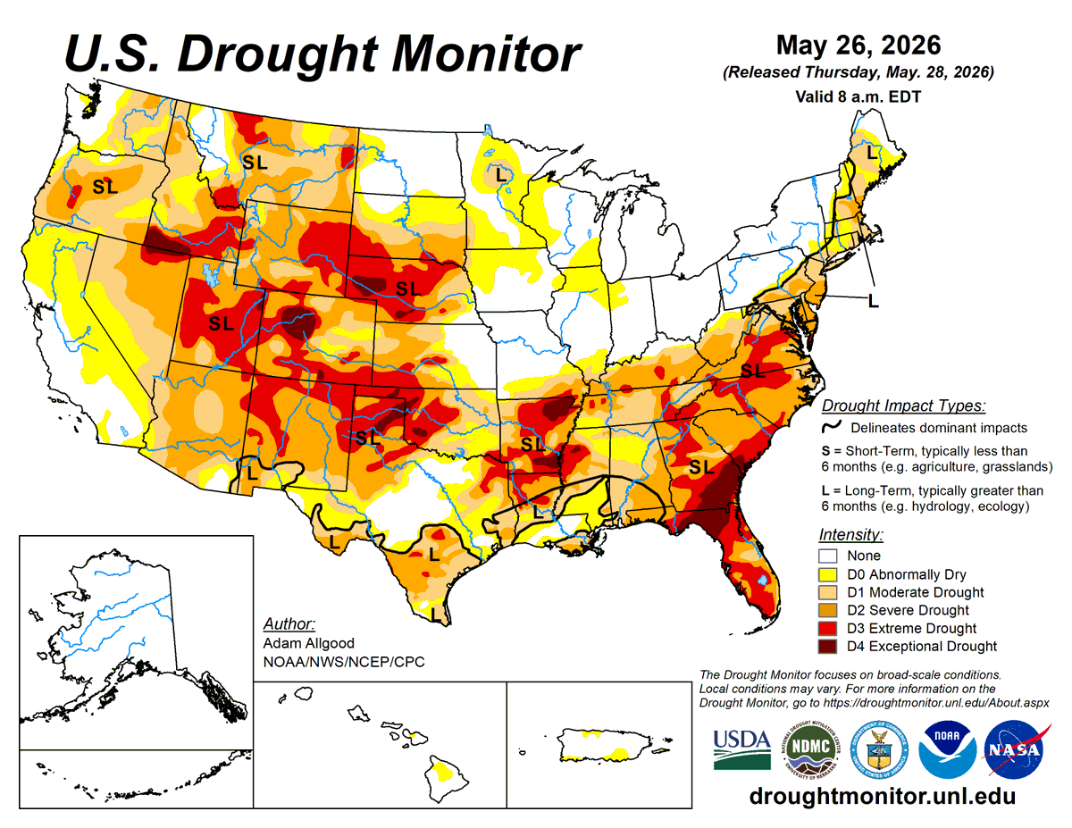
U.S. Drought Monitor May 28, 2026
For the 50 states and Puerto Rico, the U.S. Drought Monitor shows 50.77% in moderate drought or worse, compared to 52.15% last week.
#DroughtMonitor#Drought#Drought2026
An El Niño will likely arrive later in the year, according to sea level data from Sentinel-6 Michael Freilich. The satellite—which measures the height of the entire ocean every 10 days—captured a swell of warm water hundreds of miles wide in the Pacific Ocean off the coast of South America.
⛈️ Showers & thunderstorms developing along I-95 will shift inland later this afternoon
⚠️ Strong storms are possible for locations along & west of U.S-301
⚡️ By the time you hear thunder or see lightning, you’re already in danger. Keep an eye to the sky!
#flwx#gawx#jaxwx
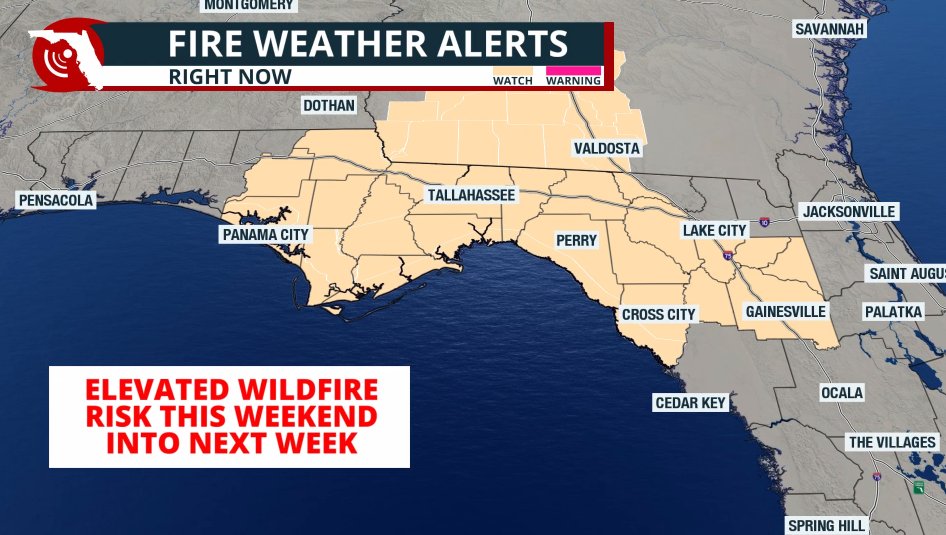
The Fire Weather Watch has been expanded eastward toward #Jacksonville, and over the #Panhandle, it has been elevated to a Red Flag Warning. Near critical wildfire risk will persist in the alerted areas through early next week. #flwx
A Fire Weather Watch has been issued for parts of the #Panhandle and #NorthFlorida. On top of the drought, we expect humidity levels to drop and winds to pick up this weekend into early next week, which could support the development and spread of wildfires.
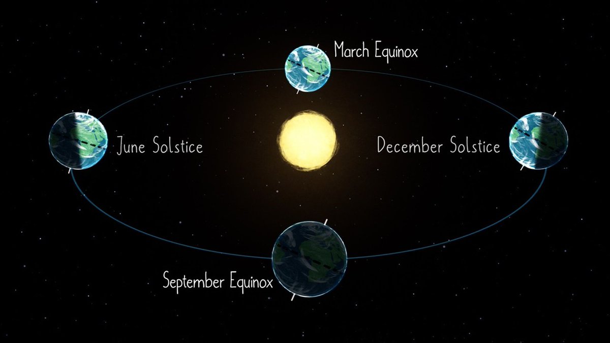
Happy vernal equinox! 🍀
Today marks the first day of spring in the Northern Hemisphere and the first day of autumn in the Southern Hemisphere.
After today, the Sun will shine more directly on the Northern Hemisphere than on the Southern Hemisphere until the autumnal equinox.
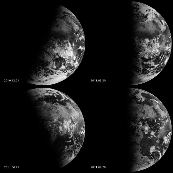
It's not just #FullDiskFriday, it's also the first day of #AstronomicalSpring in the Northern Hemisphere!
The #VernalEquinox occurred at 10:46 a.m. ET today.
In this year-long timelapse from @NOAA's #GOESEast 🛰️, see how the sun’s angle has changed since last year’s equinox due to the Earth’s axial tilt.
Happy #spring! 🌎🌸
Spring is here in the Northern Hemisphere! 🌸
Today is the spring equinox. Because Earth is tilted on its axis, the Northern and Southern Hemispheres receive changing amounts of sunlight throughout the year. At the equinox, both hemispheres receive the same amount of sunlight.
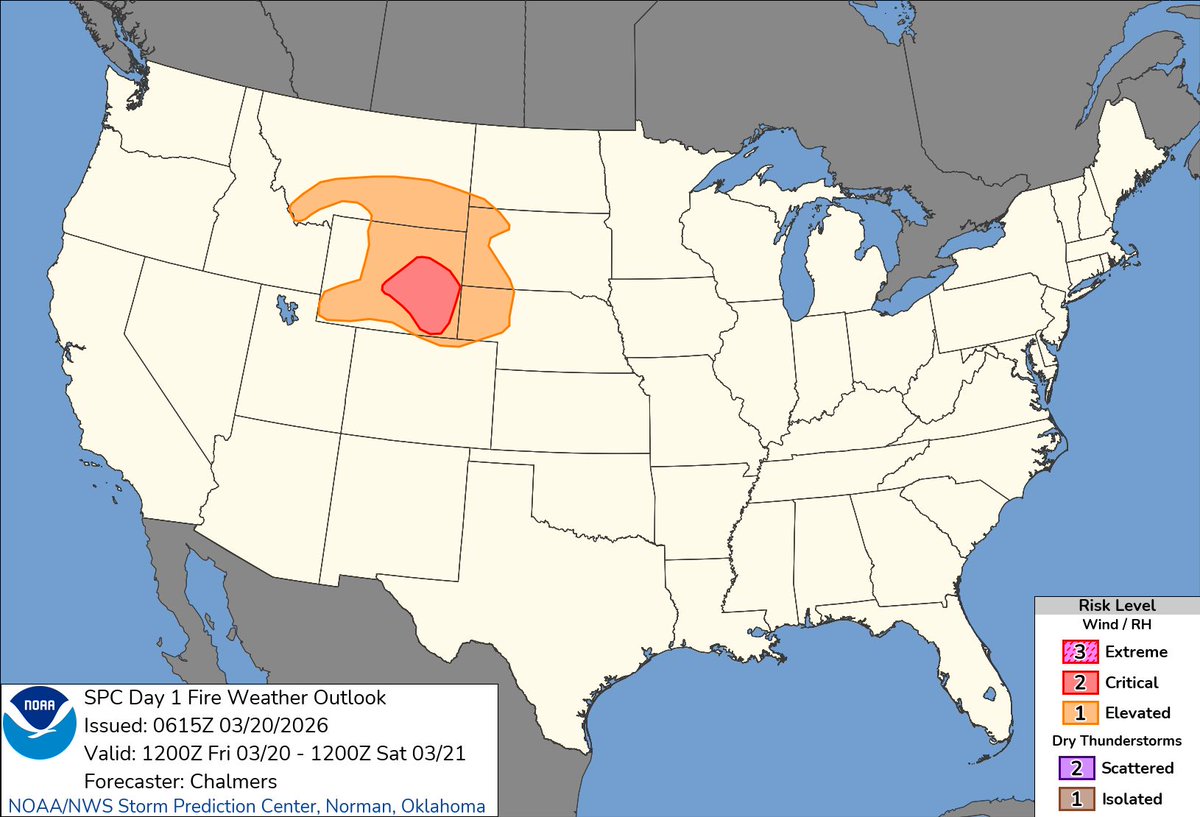
Elevated to critical fire weather conditions are in place for portions of the northern and
central High Plains today and Saturday.
Dry weather conditions with very low relative humidity values and strong downsloping winds off the Rockies will lead to extreme fire behavior and rapid fire spread.
Conditions are expected to briefly improve on Sunday, but poor conditions will return early next week.
Check the latest forecast at https://t.co/qk3BcVP5M8.
It’s the Spring Equinox—astronomical spring begins today. Meteorological spring started March 1.
Learn why they’re different: https://t.co/rRWaknryeV
How do YOU mark spring?
🚨⛈️🚨Heads up Floridians! There's a risk for severe thunderstorms across the state tomorrow, & across the Panhandle, northern, & central regions on Monday. Stay weather aware and heed any warnings that may be issued for your immediate area. #FLwx
Yesterday's high in Silver Spring, MD was 84 degrees. At 5 AM this morning it was 71, as of noon, it is 36 with moderate snow. This is why we love weather y'all. Any wild weather swings in store for you? Find out at https://t.co/VyWINDk3xP
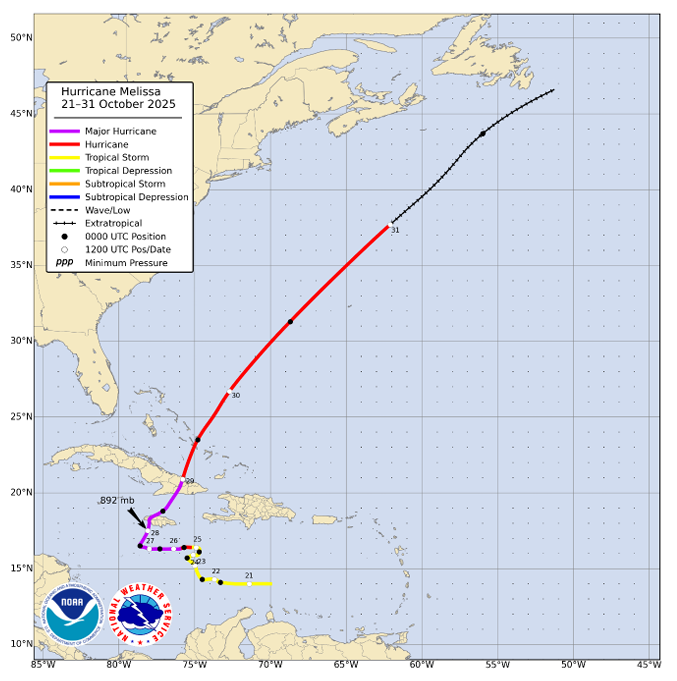
NHC has completed its post-analysis and Tropical Cyclone Report for Hurricane #Melissa.
Melissa, one of the strongest hurricanes on record in the Atlantic basin, reached category 5 intensity (on the Saffir-Simpson Hurricane Wind Scale) with a minimum central pressure of 892 mb and brought catastrophic wind and storm surge impacts to portions of western Jamaica. Melissa’s slow motion also produced heavy rainfall and catastrophic flood impacts across portions of the Greater Antilles. As of the release of the report, Melissa is responsible for 95 fatalities.
The report is available at https://t.co/ysyBlHTvYC
All reports for the 2025 Atlantic hurricane season can be found at https://t.co/c52ijljbXV
Ahead of hurricane season, Florida officials have unveiled a new emergency operations center built to handle the most powerful storms. #floridastorms https://t.co/bMR1ZSNMPY