Call for submissions! The sixth edition of IIHS' annual research conference #UrbanARC will be online from 13 to 15 January 2022.
We invite scholars and practitioners to send in their proposals by 21 November 2021!
More details on the theme: https://t.co/O5owOMw5Uo
@GautamBhan80
Geospatial Lab @iihsin is recruiting for an internship position of "Developer - Mobile GIS & Survey Platform".
The internship is paid and will be for a period of 3 months at IIHS, Bengaluru.
More details and application form here - https://t.co/9Rq5nZsiQ3
#gis#internships
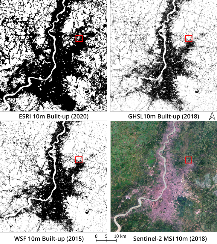
Comparing built-up and population datasets available for India, including the 30m population dataset developed by my colleagues at #IIHSGeoSpatialLab@iihsin. Preprint available at: https://t.co/sLjptOkc7x.
Image from our recent preprint that compares 10m global built-up (BU) datasets for Kolkata. These are: BU class from ESRI’s land cover, World Settlement Footprint by @DLR_en and GHS-BUILT-S2 by JRC of @EU_Commission. 🧵
One can see how density of development and elevation are related in the map. Read the article on @TheIndiaForum to see more of these #maps and read the historical context of #Bengaluru's development: https://t.co/LmqBgetHHi
Events such as the plague of 1898 further pushed the poor, the subordinated castes & the working classes to the edges of planned development. The legacy of this is still visible when the density of development is observed in relation to the elevation of land.
We look at the history of #Bengaluru and #map the developments with relation to their #elevation in the city. What we see is that richer neighbourhoods are located on higher grounds, while the poor are left to settle on lower grounds. #IIHSGeoSpatialLab
An example is the development of old #British neighbourhoods on higher ground. The Indians who worked in British areas were housed in the valley through which water flowed into #Ulsoor lake.
While #reports or #policypapers contain useful information, it is often not accessible to wider audiences. Learn different methods of representing your research in IIHS' latest online course, ‘Writing and Disseminating Grey Literature’ on @coursera: https://t.co/CUzq44lDKA
Our article looking at Bangalore's development in relation to its topography, visualized through maps and placed within the context of Bangalore's history.
"In #Bangalore's rugged topography, those who were better off would live on extensively developed layouts on the higher grounds often at the expense of the marginalised, who were compelled to live in densely populated neighbourhoods in low lying areas."
https://t.co/4WuVcaZNwA
These images show the building height (BH) for #Mumbai. BH data is usually collected through LIDAR and ground surveys, both are too expensive to scale up to entire city or larger areas. We present an alternative for city-wide BH generation.
(1/5)
Supreme Court directs courts in the India against misogyny and Gender stereotypes. Gender sensitisation to be in foundational training of judges. Rspct...Justice Bhat, AG KK Venugopal and Adv Aparna Bhat
No place for misogyny in court....in society #GenderJustice#GenderEquity
How do we imagine more inclusive urban mobilities? Join us for a panel discussion on urban transport and mobilities with Kshiti Shobha Vikas, Saakshi Joshi, Prajwal Nagesh and Neha Gupta. The panel will be chaired by Pooja Rao, #IIHSin. Register here: https://t.co/oDUypriRIR
Happening online. 14-16 January. https://t.co/oWwNfQ4U8r has detailed schedule of the conference. You can register for sessions that you are interested in. #conference
IIHS' Urban ARC is back! The annual research conference will host sessions on urban mobility, social identity, media imaginaries, climate change, communities, urban services & more, from 14 to 16 January. Head over to our website for more information: https://t.co/A6sRVdSonQ
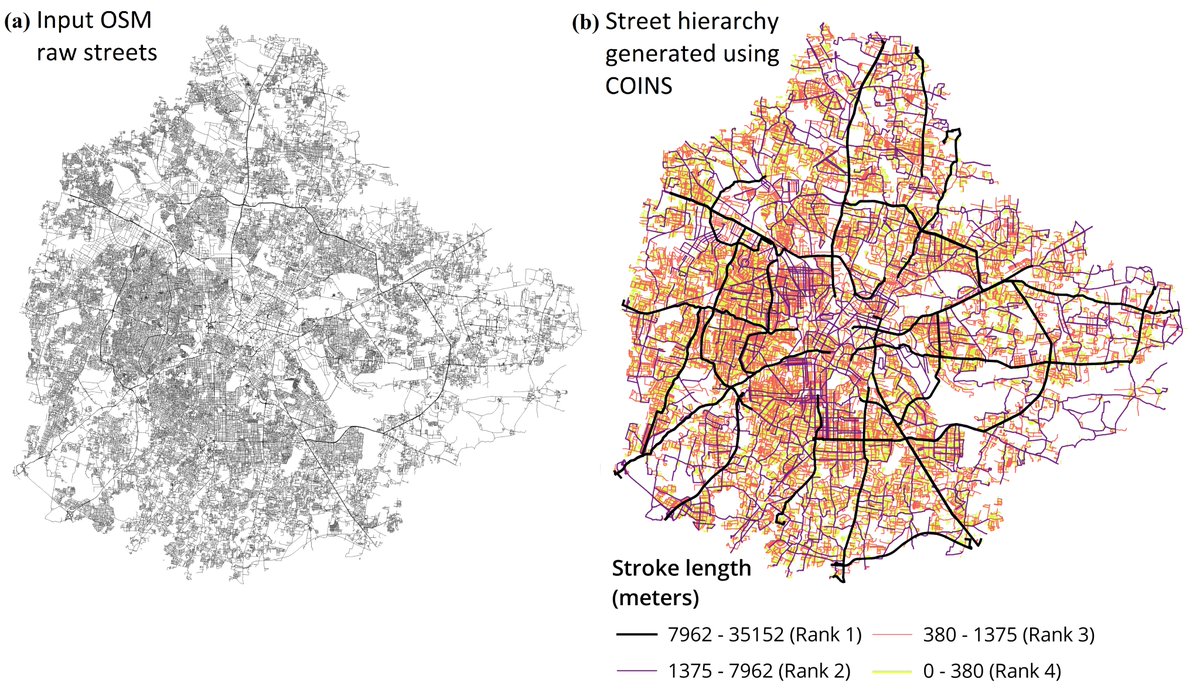
All of us working on Indian cities have often faced the issue of not finding street hierarchy maps! Now, you can use our open-source tool COINS to extract street hierarchy from OSM data.
To know more about the algorithm, read the paper here: https://t.co/Q1mq8NE2to
The open-source tool to create street hierarchy maps from raw street data is available for use. To know more about the algorithm, read the paper here: https://t.co/Q1mq8NE2to
#opensource
COINS is an open-source scalable tool and allows users to automate street hierarchy generation. COINS is available at https://t.co/d1rnw4KvhX. The figure shows street hierarchy maps for 9 different Indian cities.