While looking at the forecast chart that was valid for the last 24hrs ending this morning on 30th July shows that few models have exaggerated the rainfall amount & other few models have under-estimated the overall quantum..
The sad reality is that we are just obsessed with extremes numbers/ events so even a 5 or 10cm events are just ignored. we shouldn't forget that even 5,10cm events are also equally dangerous,
life threatening at one point of time.
Conventional models like ECM,GFS underestimated the numbers but ensemble members of few models have been close to the reality
Considering the complex topography, Models tends to fail in foreseeing the exact rainfall amount in most cases..
It is really a challenging task for these models to predict the exact quantum. Model microphysics, Convection scheme varies from one model to other model so obviously the output varies.
#Monsoon #Monsoon2024 #swm2024 #keralaflood #Kerala #Keralalandslide #KarnatakaRains #MISO
Deep convective cloud field seen increasing steadily since yesterday & slowly this should propel the lower level wind field leading to strengthening of winds . Again this strengthening would increase the lower level convergence manifold. interesting rainy days ahead #Monsoon #Monsoon2024 #MJO #TamilNadu #Kerala #Karnataka #BangaloreRains #Bengaluru #SriLanka #Chennai
Dc : @Windycom@eumetsat
Southwest Monsoon outlook 2024
Are we about to witness a Monsoon season which could end up as a record breaking, flooding Southwest Monsoon season?? Yes ,conditions for Monsoon 2024 looks very robust for a strong Monsoon conditions this year.
Check out the Interesting analysis based on Dynamical models seasonal forecast & Composite rainfall -statistical analysis .
Positive IOD & La Nina conditions likely to coincide with the Southwest Monsoon 2024. This is said to be an unusual & rare combination which we don't often .
Before #LaNina evolution in the pacific, Majority of the models expects Positive IOD/+EQUINOO event to develop over EQ Indian ocean in the coming weeks/Months. Both these phenomenon are going to be concurrently active along with the Monsoon Background conditions. So Lanina/IOD more likely to favor positively during peak monsoon months of JAS.
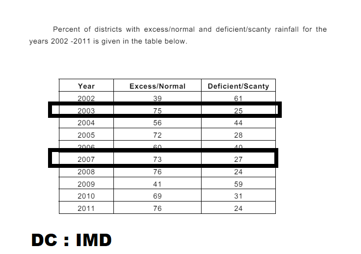
Considering the last 60 years , we had seen this combination of Lanina & +IOD only in the very few years. 1961,1966,1967, 1983, 2003,2007,2008 & 2011 are the sample years taken for this analysis. Out of this 9 years, 1966-1967, 1983 ,2003 & 2007 are the emerging lanina years after a strong el nino event. Though 1961 +IOD/Nina emerged after a non-elnino year, I have added it to the composite just for the reason that we had only very few samples of Lanina & Positive IOD
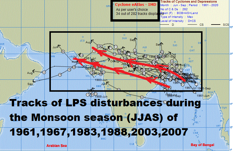
4. Tracks of Monsoon low/Depression during these years looks encouraging where we could see disturbances having a long & steady track ,reaching West-Northwestern India & few further moving into Pakistan/ North Arb sea so this gives a clear hint of more rains to West/NW India, Pakistan ,through Monsoon low/depressions during JAS.
5. In response to evolving Lanina conditions & IOD, there is an anomalous westerly shift seen in the main Monsoon convergence area which is forcing the Arabian sea adj Indian landmass to act as an area of large scale rising motion so this clearly support Monsoon background conditions for a strong rainfall throughout the season..
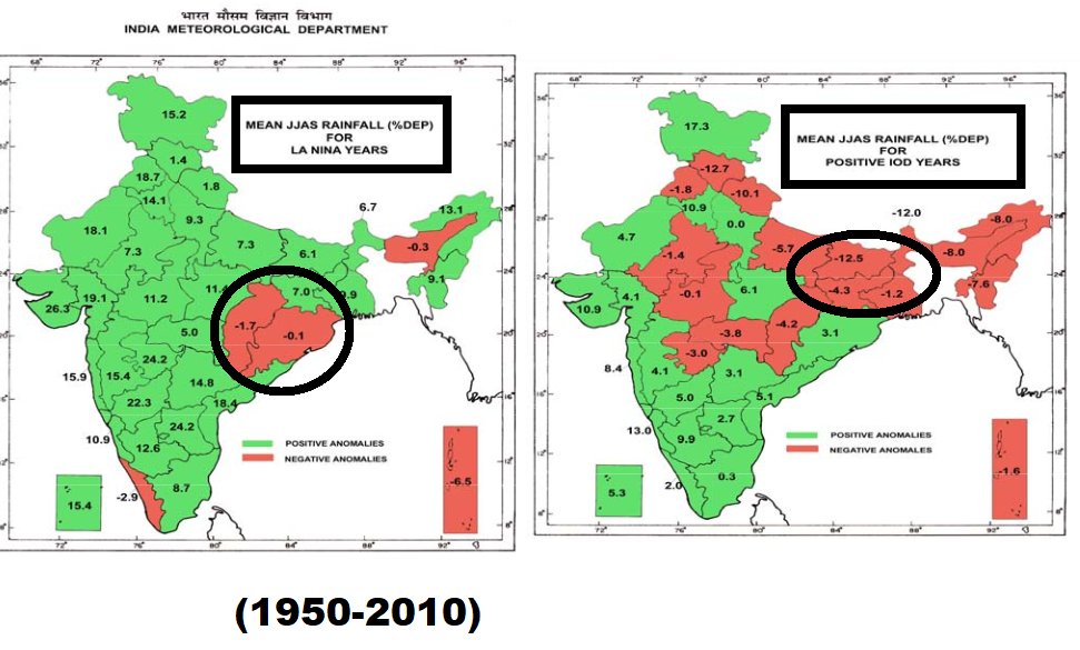
6. There is a weak probability /chance for the monsoon rains to fall on the Negative side as slightly below normal range over some parts of Eastern-East central India . This usually happens with Lanina /Negative IOD. More active western side of the trough with strong convergence over western India & divergence area over Eastern India adj North Bay. Lets see what this combination offers for East /Northeast India.
Conclusion :
1. Most parts of west/NW India may see excess/above normal rains. so very High probability of Floods exist during peak/late monsoon season .
Entire #Pakistan , #Gujarat, #Rajasthan adj NW Indian states like Punjab,Himachal #Maharashtra , #Telangana #MadhyaPradesh #Chhattisgarh #Goa #karnataka #Kerala &Monsoon region of AP would see above normal/excess rains. TN ,Rayalaseema may see increased convective rains considering Lanina conditions. West central Bay might be active during monsoon season.
2.Monsoon 2024 may make its first appearance over extreme parts of South-SE Bay around 1st week of May through Northward moving BSISO. This period often coincides with cyclogenesis considering the seasonal change in winds/establishment of cross eq flow in the lower parts of Bay of Bengal. +IOD conditions would enhance the Cross eq flow over Bay of Bengal. Also so the monsoon establishment would be at least 5-6 days earlier than normal for Andaman islands, SriLanka & Kerala.
But it may not be smooth as the main negative factor would be WIO standing wave which is creating strong suppression over MTC/Indo-China. Anomalous Easterlies may offset Cross eq flow to some extent.. If it remains strong in the coming weeks,also if cyclones in Arb sea disrupts the flow, then the onset equation may change. let's see..
3. Considering Lanina influence, Monsoon may extend into early oct . however too early to take a call on it.
4. Number of districts witnessed above normal /excess rains were relatively high during 2003,2007 ,2011
5. Each year would be unique in one or many ways. We are trying to find a similar ENSO/IOD conditions to foresee the prospects of seasonal Monsoon rainfall.
#Pakistan #SriLanka #India #Monsoon2024 #Monsoon #LaNina #LaNina2024 #IOD #Indianocean #NOAA #ECMWF #ERA5 #TamilNadu #Kerala
DC :
1.Disturbance track from @Indiametdept E-Atlas
2. Lanina/+IOD composite rainfall deviation compsite chart from @IMDWeather@Indiametdept
3. ERA5 Reanalsyis plots @ECMWF@NOAA@NOAA PSL/WRITS @CopernicusECMWF
The trough in the mid-latitude westerlies is gradually heading east now. Rain will continue over North East India and Bangladesh for the next 2-3 days, but will gradually reduce over Odisha and West Bengal.
Very strong trough deepening at upper-levels over east-central India - favourable upper-level divergence.
Low-level cyclonic circulation is present over Vidarbha/MP region with moisture coming in from BoB.
Expect strong TS/squall line
Forecasted trough position later tonight
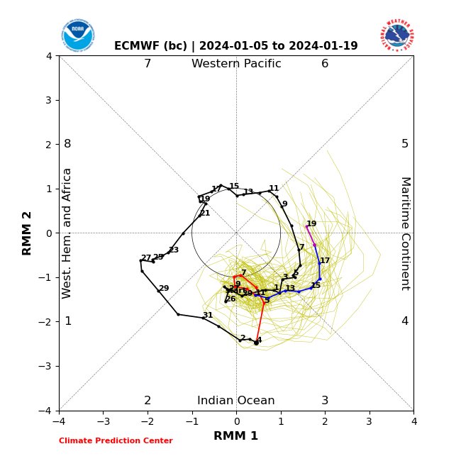
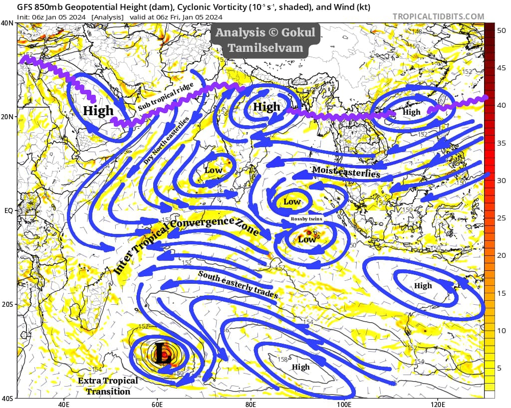
Active MJO in the Indian Ocean has spun the twin Rossby wave type of circulation in the eastern equatorial Indian Ocean. Apart from the intraseasonal component, the seasonal ITCZ is shifting gradually southward over western Indian Ocean with an IOD signal in the background.
Vorticity field at 925mb -Animation shows trough extending from Arb sea disturbance towards Coastal Karnataka at lower level causing sharp ,significant convergence over south coastal karnataka & Kerala for next 2 days so models are expecting heavy-Very heavy rainfall at some stretches of kerala adj south coastal karnataka
dc: @Weathernerds
#Kerala #Karnataka #KeralaRains #Mangaluru #KarnatakaRains #NEM2023
#MJO is active in the Indian Ocean. Large scale precipitation associated with MJO is set to trigger several Cyclonic circulations over equatorial IO. The seasonal ITCZ over the southern hemisphere is expected to be active with favorable environmental conditions.
We are proud of doing science. We love what we do.
But sometimes we are ashamed of our economic conditions.
Funding agencies are responsible for this. Improve your system
#realeaseCSIRFellowship@IndiaDST@HRDG_CSIR@dgcsirIndia