Deeply in love with mountain environments. Hydrology, climatology, global environmental change, climate impacts. IPCC WGI AR7 Review Editor & AR6 Lead Author.
New paper led by @CUBoulder PhD student Max Elling shows that tropical oceans drive year-to-year malaria variability in Malawi. Soil moisture is the key link and a foundation for early warning systems.
https://t.co/MXLgOhIXVy
@CIRESnews@CUBoulderATOC
🌴Thanks to satellite data, we know how much forest the world is losing, and where.
Unless we know what’s driving tree cover loss, it’s impossible to know if it’s permanent or temporary; what the impacts are for people, nature and climate; and the solutions to keep forests standing. That’s where new data comes in.
Data on @globalforests, developed in collaboration with @GoogleDeepMind, reveals that 34% of tree cover losses worldwide from 2001-2025 were likely the result of permanent land use change, meaning trees won’t grow back naturally. This percentage nearly doubles in tropical primary rainforests, to 60%.
Learn more about what's driving #TreeCoverLoss👉 https://t.co/cbm9X8krwz
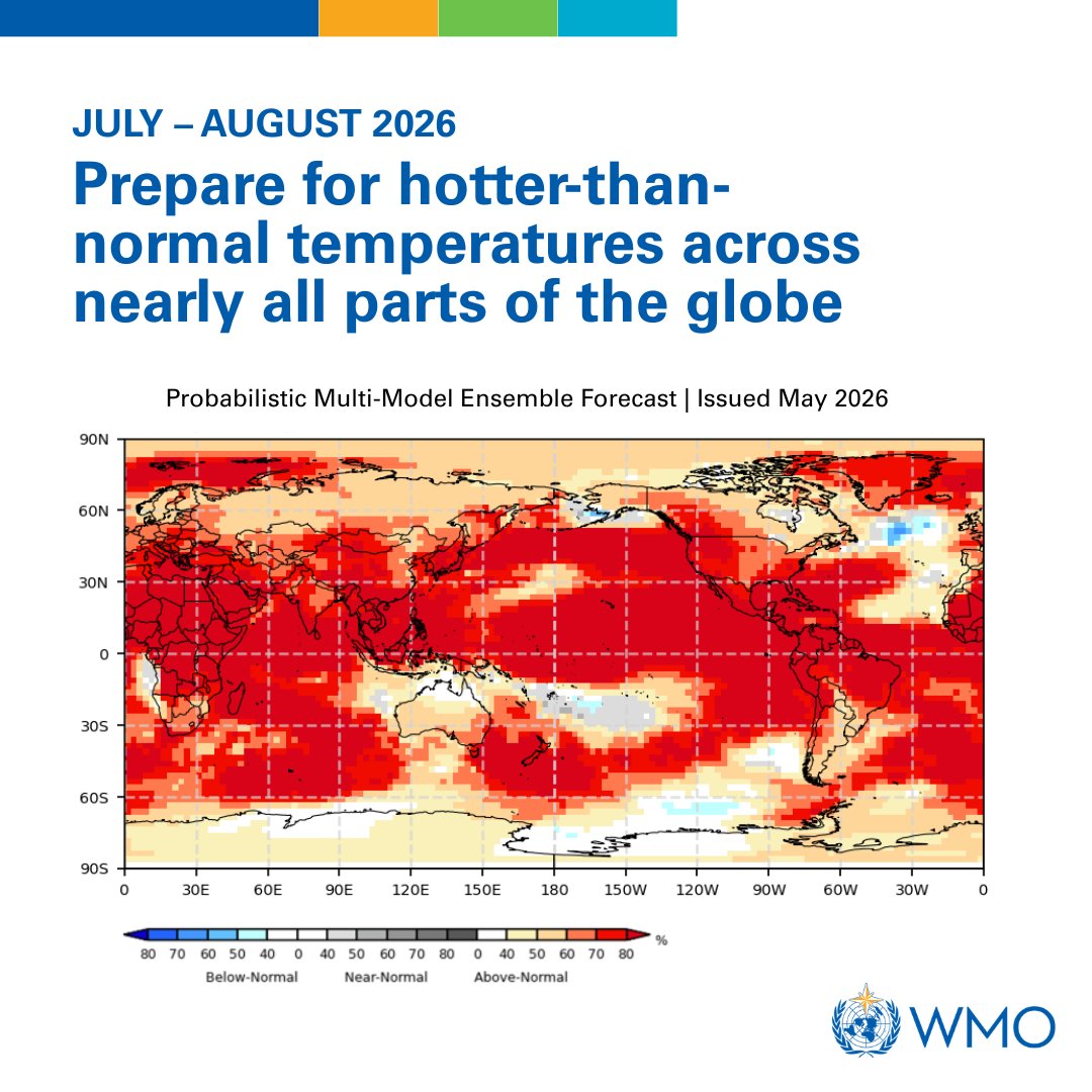
Fueled by unusually warm ocean waters in the tropical Pacific, El Niño conditions are developing and are set to influence global temperature and rainfall patterns.
Here's what you need to know.
Wildfires are creating unhealthy air far from active flames.
According to a new NASA study, wildfires have worsened ground-level ozone pollution across much of the U.S. since 2015. NASA’s satellite data and models help track air quality patterns across states and fire seasons.
Climate variability can alter the risk of armed conflict. A study maps how two major climate modes—the El Niño–Southern Oscillation and the Indian Ocean Dipole—influence conflict emergence. In PNAS: https://t.co/l5AIWmhIZF
🌡️ W Europe, parts of the Atlantic & Mediterranean saw unusually warm conditions in late May.
🛰️ Based on @CMEMS_EU data, sea surface temps exceeded seasonal avg by 5°C+ in some areas. These data help monitor marine heatwaves.
🔗 https://t.co/1BqWJ8r3l3
#ImageOfTheDay#EUSpace
A large Saharan dust plume has stretched across the Atlantic from the west coast of Africa towards the Americas. CAMS data shows that large parts of the Caribbean are most impacted.
Snow-covered area across the West was 49 percent of average for May, ranking last in the 26-year satellite record. Snow water equivalent remained well below average in most states, confirming a worrisome outlook for the summer. Read NSIDC's Snow Today: https://t.co/OktLtErT9d
An El Niño is emerging. What do you know about it?
El Niño is a powerful natural climate pattern that warms ocean waters in the central and eastern Equatorial Pacific. It typically occurs every 2-7 years, but no two El Niños are exactly alike.
More ➡️ https://t.co/htyps0XfsE
⏰The countdown is on. Four weeks left to enter the #AMSPhotoContest!
As hurricane season begins, share your best shots of high winds, heavy rain, or dramatic waves for a chance to win up to $500💰
📸 The deadline is 30 June at 5:00 PM ET. Submit here: https://t.co/90XvLR9sZM
#DYK? Peatlands are estimated to occur across 177 countries worldwide!
While peatlands cover a mere 3% of the earth’s ice-free land mass, they contain 30% of the world’s organic soil carbon.
#WorldPeatlandsDay
@wmo warns: prepare for El Niño.
A warming Pacific Ocean is driving the development of El Niño, increasing the likelihood of higher global temperatures & more extreme weather in the months ahead.
Forecasts provide a window to act. Time for preparedness is now: https://t.co/8Om7CqRPKB
If you want to go further back the Central England Temperature Record is the longest instrumental record in the world.
The last three Springs have been the warmest in the 367 year records.
Chart by @MetJam_
🆕 WMO confirms: El Niño conditions are developing and are set to influence global temperature and rainfall patterns around the world in the months ahead. Most forecast models suggest it will be at least moderate – possibly strong.
Be prepared. More info➡️ https://t.co/htyps0XfsE
Watch @UN Secretary-General @antonioguterres' message about the emerging El Niño that is set to influence global temperature and rainfall patterns, increasing the risk of extreme weather in the coming months.
More information ➡️ https://t.co/htyps0XfsE
Climate curiosity: Utqiaġvik (formerly Barrow) Alaska has not yet reached 32°F/0°C this year, the latest since at least 1955.
The month of May was notably cooler than normal over Alaska and the Arctic Ocean to the north, yet Arctic-wide sea ice extent remains near a record low.
🌀 June 1 is the first day of Atlantic hurricane season! Get ready with IBTrACS, a complete dataset consisting of historical and recent tropical cyclone statistics. Access IBTrACS and learn more here: https://t.co/CYgKWXLBVC