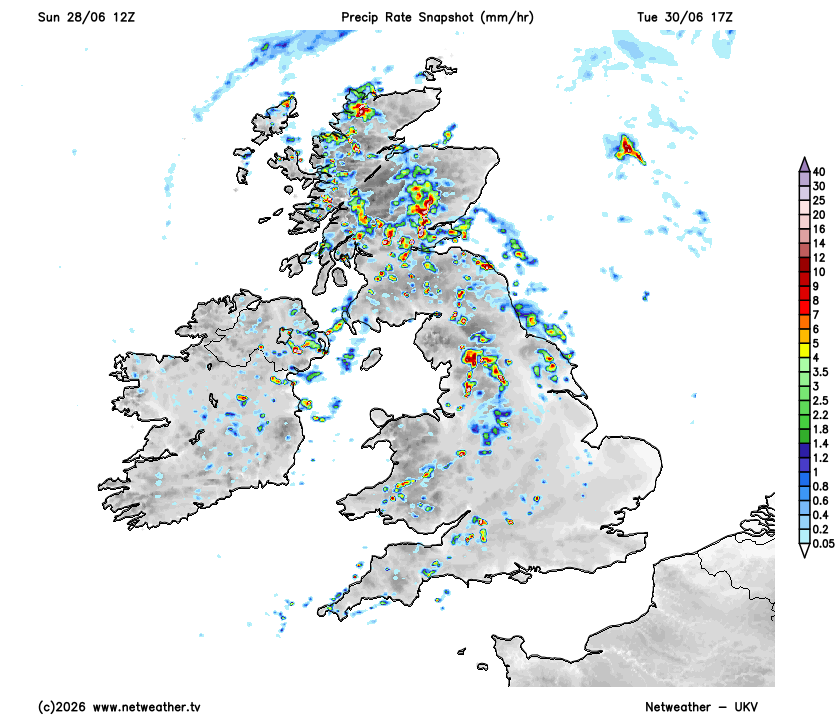
TUE 30 JUN 2026 - https://t.co/qTBc4AMsSO
Broad filling closed low eventually opening into a upper short-wave introduces increased lift around the centre of circulation across Ireland and ahead of the trough axis across broad parts of N/C England and Wales and parts of Scotland through Tuesday. A messy rash of heavy showers are expected with a few pulse type thunderstorms possible through the afternoon and evening period. Main threats torrential downpours, small hail, gusty winds and pockets of lightning. A slight conditional has been issued mainly due to lower confidence in overall lightning amounts and distribution - but generally there is a slightly elevated risk in these areas.
#ukweather A more typical day of thundery showers is anticipated across much of the northern half of the UK on Tuesday (30/06) with a classic cold-core setup. Focal areas for activity appear most likely to be in two corridors, one across N/C Scotland (A) and one for N England (B) - perhaps Lancashire/Yorkshire focused.
A: Closest to the core of the upper cold pool with ample lift from the cyclonic vorticity maximum of the shortwave trough + orographic lift over the highlands.
B: Curvature- and shear-induced PVA aloft just north of the associated jet streak, together with ascent within its left-exit region. Stronger deep-layer shear relative to area A helping with cell organisation here.
Generally pulse-type convection expected to dominate the setup. Widespread development of showers may promote occasional cell mergers and thus locally more frequent lightning in places.
May post a convective outlook tomorrow for this activity (although I am currently on holiday so no promises)
As far as I know, a UK max temp record hasn't been set in 2 consecutive months since 1911. In Ireland, that was the case in July and August 2022.
May and June 2026 both COULD possibly achieve max temp records in the UK based on these ludicrous runs we're seeing in fantasy land.
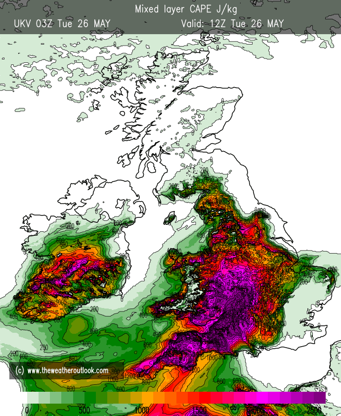
Warm moist SW Airflow will come to dominate the weather in the coming week. Upper level pattern will evolve to have a building ridge over Continental Europe and longwave 500mb trough becoming slow moving to the west of the continent. This type of set up favours slow moving rippling fronts over the N/W of the UK with pulse of rain moving East or NE along the fronts. (NW Scotland looks prone over the next week)
Warm moist high 850mb theta-w air will move north. Rain may be active and potentially heavy Tues/ Weds across Wales, maybe SW England and Irish Sea coasts and hills before pressure builds from the South.
At the same time a ridge is building at depth through the mid troposphere allowing heat to build through descent and advection to bring the likely highest temperatures of the year so far into Iberia, France then into Central Europe.
As pressure builds and the trough approaches late in the week the flow will back more Southerly and bring higher temps into Southern England and spreading NNE. However risk of Destabilisation in the plume axis or multiple axis with some evidence of 2 sets of destabilisation. 1 ) on the outer 16-18C Theta -W and the other on the 20-22C Theta - W over France.
This type of set up is prone to changes so i wont go into too much detail now, but the set up is increasingly looking likely to give rise to some potentially very warm humid air coming north with risk of elevated potentially severe convection developing due to the bulk shear aloft with strong 300-500mb flow in the ascending side of the trough.
Such sets up can give rise to elevated multicell and the merging into the potential of MCS type structures if enough CAPE is available and enough of a supportive kinematic environment (Speed and Sheer of wind aloft)
ECMWF showing more disruption in the approaching trough than EC AIFS, GFS, GFS-AI (very quick) or UKMO Global
Selection of Graphics to support the text. Detail will change and is for illustration of the type of set up.
Becoming Very warm if not hot and thundery by the end of the week and into the weekend with risk of some very high temps and possible intense elevated plume type thunderstorms.
(also note considerable risk of pulses of frontal rain in the NW leading to forecasting Skew's during the week) (many mention of hot and sunny when many in the N/W will not see such conditions)
Paul
A bit late to post this, but over 5 years down the line and with tons of amazing memories, I finally achieved my goal of a First-Class Master's in Meteorology.
Huge thanks to @UniofReading & @ousom for an awesome journey. I'm loving continuing it at DTN as a meteorologist ⛈️😄
Omg.
Got accepted onto a Meteorology masters course at @UniofReading!! 1yr in Oklahoma sounds scary now but will surely be an amazing opportunity.
A (hopefully) incredible journey begins later this year 👀
I didn't think I'd get this far, so excited :D
There will be immense convective available potential energy (CAPE) over SW UK this afternoon.
The higher the CAPE, the more powerful any thunderstorms have the potential to become.
BUT this only gets realised if there's sufficient moisture & the 'capping inversion' is broken.
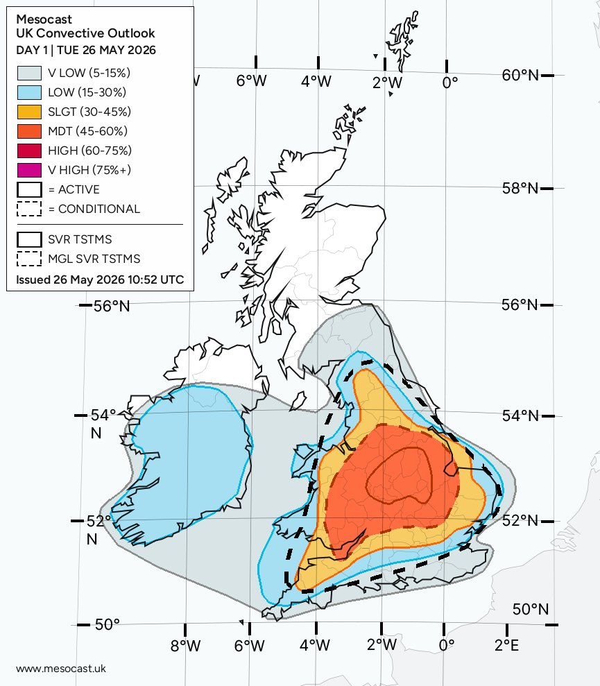
Re-issue due to date issues. Please see end of post.
TUE 26 MAY 2026: https://t.co/wnMBE22oiC
Update 10:40am on TUE 25 MAY 2026 to introduce active higher confidence moderate risk polygon for Birmingham/Leics/Coventry West Midlands areas, East Midlands inc. Nottingham and fringes of Lincs. Lincoln etc. where consistent modelling of convergence heightens confidence. Elsewhere in immediate surrounding counties a conditional lower confidence moderate risk polygon remains where upgrades to active may occur through the day.
Slight risk of marginally severe/strong thunderstorms for Tuesday with a moderate conditional polygon in place for the potential for more widespread convective development subject to sufficient triggers/conditions being met. Regardless of conditionality, slight is in place and some strong thunderstorm dev. expected with possibility of intense very slow moving downpours + attendant flash flood risk, very frequent lightning, hail upto 2cm in diameter, locally damaging wind gusts to 50mph. Brief spins up and rotation can not be ruled out, although these likely to be weak. There is the potential for very strong thunderstorms on Tuesday with particular forcus across the Midlands/poss. areas close to Linc. + Wash area too.
A big thank you to Jonathan Trigg @ApexPredator35 for pointing out discrepencies in the date both as a typing area and actually written into the graphic. This was a softwware bug we were unaware of, so thank you. You're a star! ⭐️
So Elon goes "Kill the Bill!" and Trump goes "Elon has TDS!" so Elon goes "I'm the reason Trump won!" so Trump goes "we waste billions on Elon!" so Elon goes "Epstein!" and a flunkie goes "Deport!" and Elon goes "Impeach!"
And THAT'S why women are too emotional to be President.
TORNADO OUTBREAK IMMINENT central into eastern Oklahoma, northwestern Arkansas into western Missouri this afternoon and evening!
Supercells are already erupting across central into eastern Oklahoma and will pack a threat of all hazards including strong-to-violent tornadoes.
Stay tuned to severe weather watches and warnings in this risk area!
Just insane that a single supercell has caused several different tornadoes and destructive hail over a 500+ mile path that lasted nearly 10 hours Friday night. Truly very uncommon.
And there you have it. At least a dozen tornadic supercells in an STP bullseye of 9, smack dab in the center of an SPC High Risk. We can stop complaining now, or rejoice, or just appreciate the NWS.
The Earth had its 3rd-warmest February on record.
The globe saw its smallest February sea ice coverage in 47 years: https://t.co/TyaZ6osUR9
This is not good. #ActOnClimate#climate#energy