Emergency Management means being ready and YOU are your own best first responder. Follow us to learn how to stay #LonghornReady for any emergency on campus.
🔔 Myth vs. Fact: Fire Alarms
Myth: It’s probably just a drill, so it doesn’t matter.
Fact: You don’t want to get into the habit of assuming alarms are “just drills.” If an alarm is real, dismissing it could put people at risk.
#LonghornReady#CampusSafety
A line of showers will continue to move eastward through the Hill Country into the I-35 corridor this morning. Some pockets of moderate to heavy rainfall are expected, with a quick 1/2 to 3/4" of rainfall possible. Isolated thunderstorms may develop within this line of showers.
We’re highlighting Longhorn Alert—UT Austin’s emergency notification system.
In an emergency or incident, Longhorn Alerts provide timely information and clear instructions. Read carefully. Act quickly. Stay safe.
#UTReady#LonghornAlert
Myth: Preparedness plans stay the same once they’re created
Fact: Plans are reviewed and updated as campus needs, spaces, and activities evolve.
#LonghornReady#CampusSafety
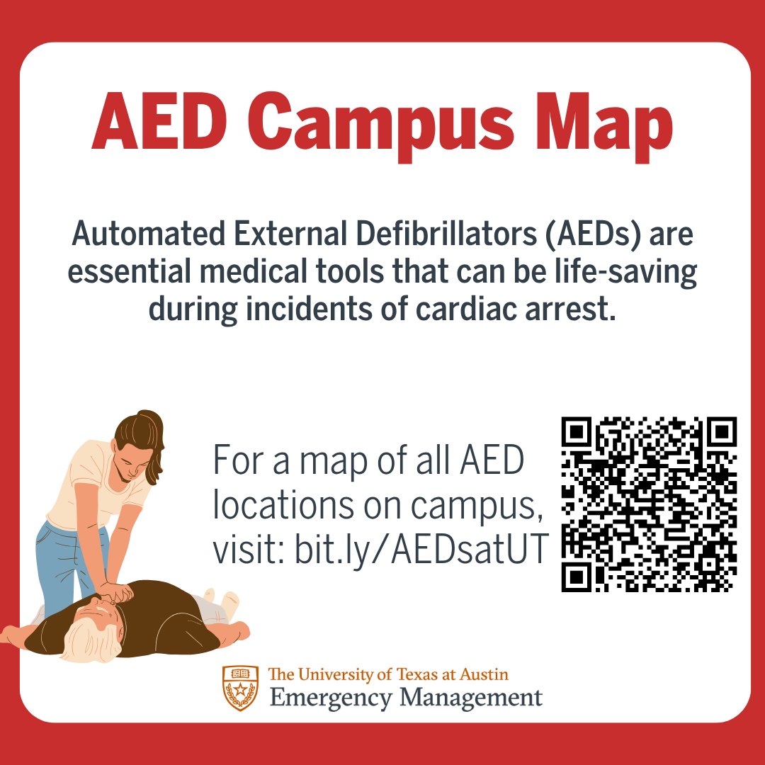
💡 Fun Fact: OEM helps manage an estimated 300 AEDs across campus!
Knowing where AEDs are located can save valuable time in an emergency.
See the campus AED map here: https://t.co/wJHH6ZFPHn
#LonghornReady#CampusSafety
This Halloween, don’t wait for a scare to be prepared. 🕷️📲
Sign up for Longhorn Alert to receive important emergency notifications, severe weather updates, campus closures, and other urgent information straight to your phone.
🔔 Stay alert. Stay informed. Stay prepared.🤘
We offer FREE emergency preparedness trainings for students, staff, and faculty—hands-on and easy to schedule:
✅ Building Emergency Management Team
✅ Building Safety
✅ Stop the Bleed
✅ CPR/AED (Compression-Only)
🔗 Learn more & request a training:
https://t.co/XQIE3FnLxs
🎒 Emergencies can happen anytime.
Keep a few essentials in your backpack:
🔋 Charger
💧 Water bottle
🩹 First aid kit
🔦 Flashlight
🍫 Snack
Preparedness starts with what you carry.
#LonghornReady#CampusSafety
DID YOU KNOW? ❤️
CPR can double or even triple a person’s chance of survival after cardiac arrest. Knowing what to do could help save a life.
Learn CPR. Be #UTReady!
Sign up for training today! Link in bio!
🩸 Stop the Bleed. Save a Life.
Learn to recognize life-threatening bleeding and apply a tourniquet through hands-on training with UT OEM.
🎓 Open to the UT community. Sign up today! Link in bio!
⛈️ Stormy skies? Stay weather-aware!
Thunderstorms and lightning can move in quickly. Keep these tips (and more) in mind:
⚡ Hear thunder? Head indoors.
🌳 Avoid trees, open areas and water.
📱 Monitor weather alerts!
Stay safe, Longhorns! 🤘🧡
🚨 PREPAREDNESS MYTH VS. FACT
MYTH: “I need to buy a bunch of emergency supplies.”
FACT: Start with what you already have! 💧🔦📱🩹 Water, flashlights, chargers and first-aid supplies can all help you prepare.
Start small. Build over time. 🤘
🚨 Preparedness Myth vs. Fact
❌ MYTH: Preparedness is only for natural disasters.
✅ FACT: Preparedness helps you respond to many emergencies, from severe weather and fires to medical emergencies and power outages.
Be #UTReady! 🤘
🚨 Be #UTReady by knowing your building!
📍 Building name & address
🚪 Nearest emergency exits
📱 How to receive Longhorn Alerts
A little preparation can help you respond quickly and safely when it matters most. 🤘
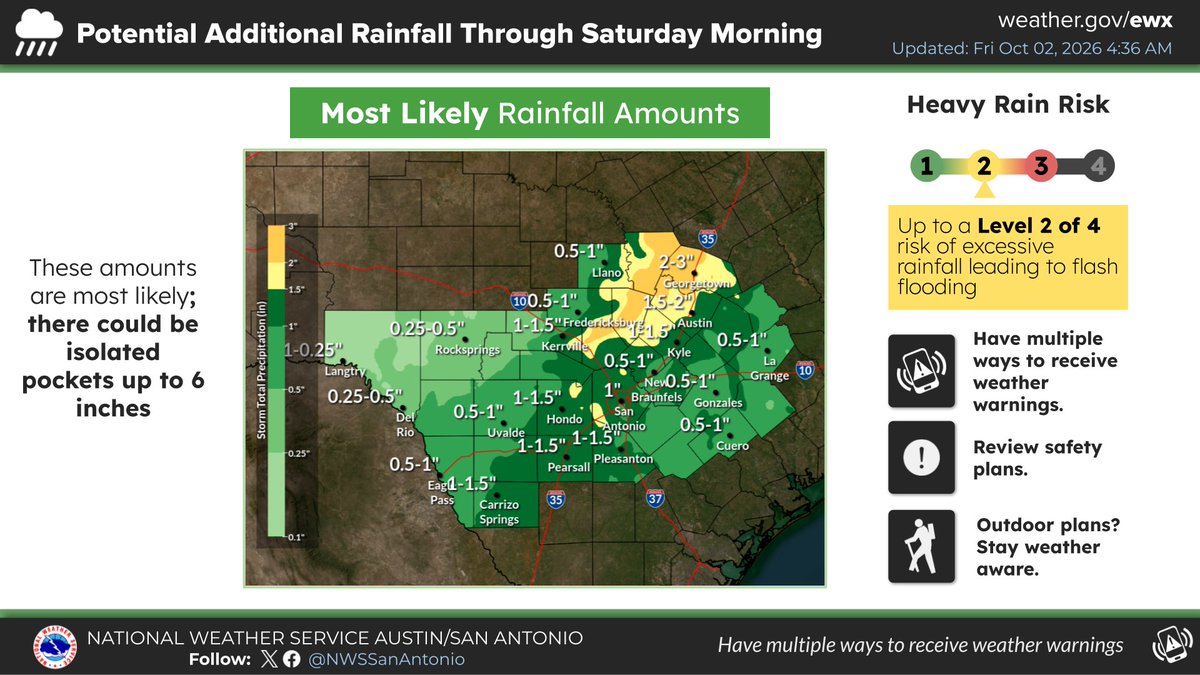
Scattered showers and thunderstorms continue across the area today. Additional rain amounts will generally range from 0.5 to 3 inches, though locally higher amounts up to 6 inches remain possible. Stay weather aware if you have outdoor plans today! #txwx
The Flood Watch has been expanded eastward. 1 to 4 inches with isolated total up to 6 inches area possible across the inland Coastal Plains over the next several hours. Re-development of heavy rainfall back into and west of the I-35 corridor counties is possible late tonight.
The anticipated cold front has slowed compared to previous forecasts. Below is the updated timing of arrival of heavy rainfall for south-central Texas for today. Stay tuned to trusted sources for changes in the forecast and issuance of any Flood or Flash Flood Warnings.
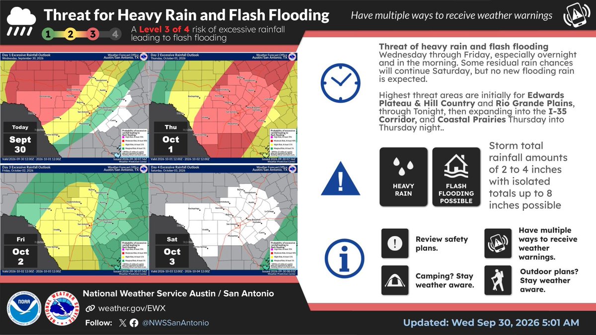
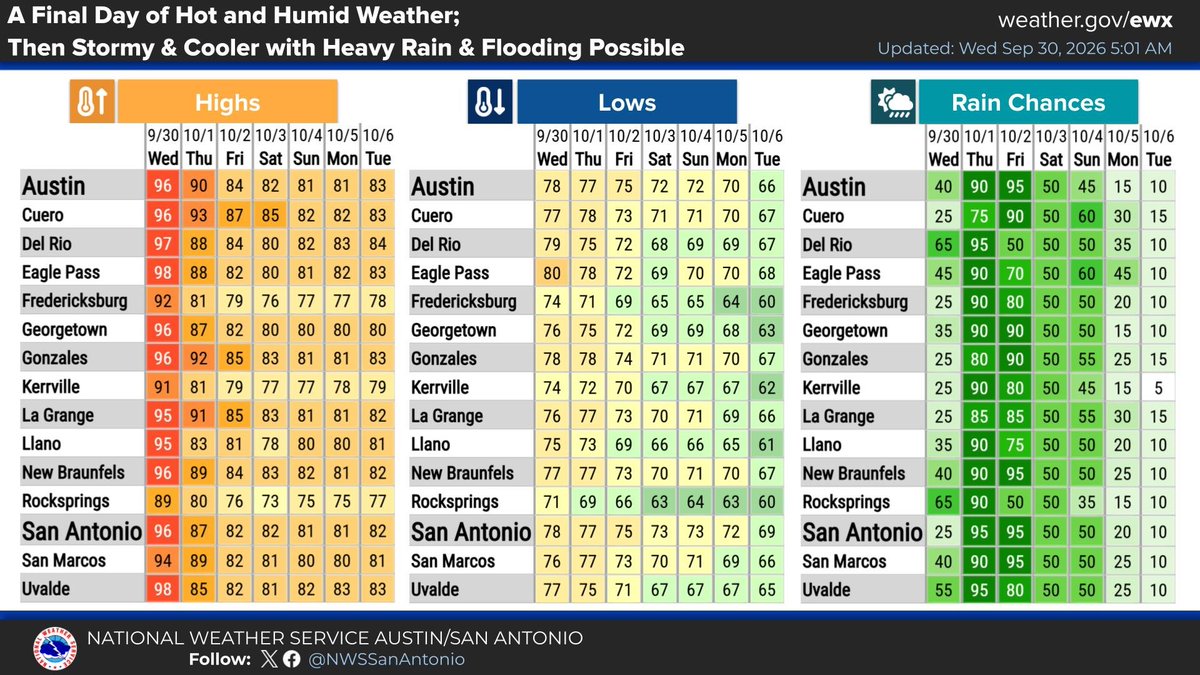
A storm system will bring heavy rain and flash flooding through at least Friday. A Level 3 of 4 threat is active on Oct 1. Expect 2–4 inches of rain, with isolated amounts up to 8 inches. Mild and drier weather arrives next week after a mostly damp weekend.