Welcome to SeaTactics! We're usually not very active on this platform, but you can learn more about our sailing-specific weather support at our website https://t.co/ioVOy2rDRM, or by emailing [email protected]
@NWSTampaBay Hi! Just a friendly FYI... your "today" graphic on the office's homepage is from yesterday. It says Highs in the 70s but the graphic shows highs of upper 80s to 90 😁.
Thanks for all your hard work though!
@mattlanza the comments from his followers are ROUGH. I learned the hard way... if you say anything other than praise, his followers will rip you apart with personal insults. thats why I don't do SM forecasting (which his ppl pointed out, calling me a fraud - bcus I don't tweet!😁)
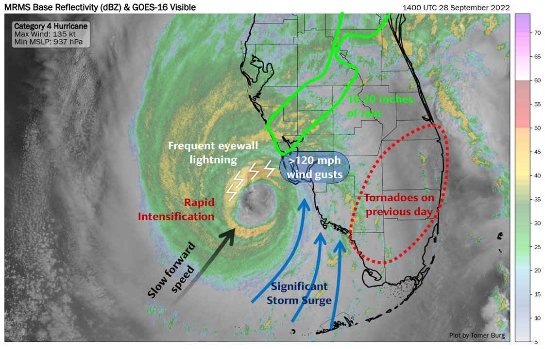
I tried to sum up the main features that made Ian one of Florida's worst storms - between its east shift into the Cape Coral region, slow forward motion, storm surge, outer rainband tornadoes, excessive rainfall & gusts over 120 mph.
My thoughts are with everyone affected.
Full storm-centered loop of Hurricane Ian as seen from the US-based radar network, from its Cuba landfall to South Carolina.
Follow Ian's evolution as it undergoes a quick eyewall replacement cycle, rapidly intensifies before FL landfall & transitions to a post-tropical cyclone.
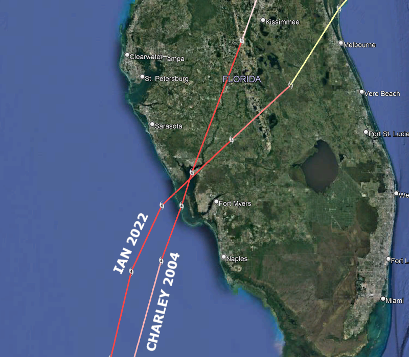
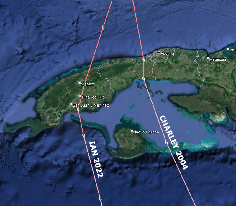
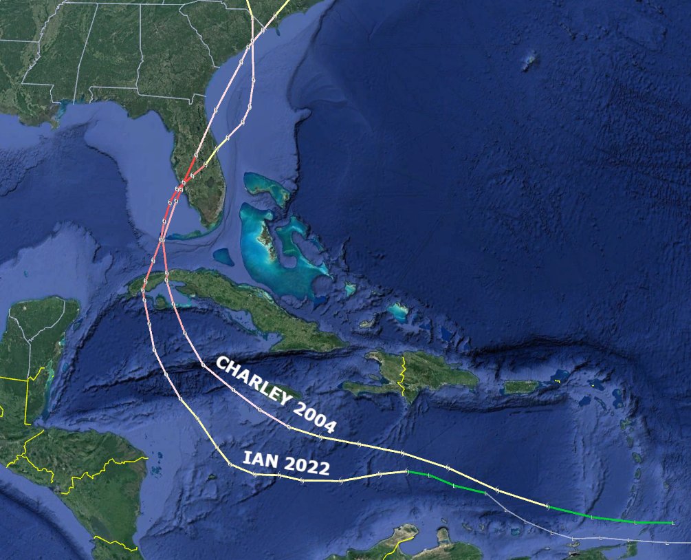
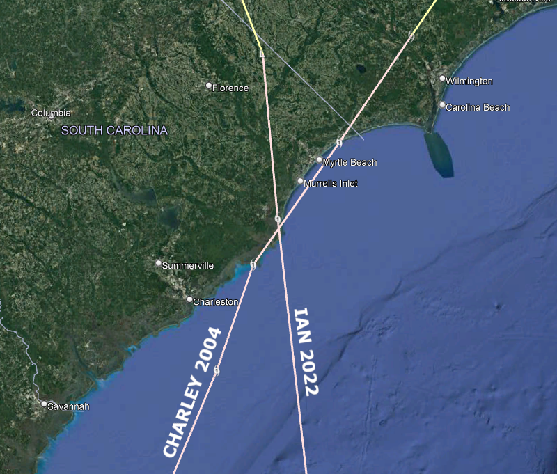
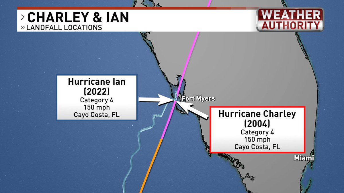
For posterity, the full tracks of #Charley 2004 and #Ian 2022, with zooms on their three landfalls, two of which were at identical locations. Pretty bizarre.
Both were Category 3 hurricanes at #Cuba landfall, Cat 4s at #Florida landfall, Cat 1s at #SouthCarolina landfall.
For posterity, the full tracks of #Charley 2004 and #Ian 2022, with zooms on their three landfalls, two of which were at identical locations. Pretty bizarre.
Both were Category 3 hurricanes at #Cuba landfall, Cat 4s at #Florida landfall, Cat 1s at #SouthCarolina landfall.
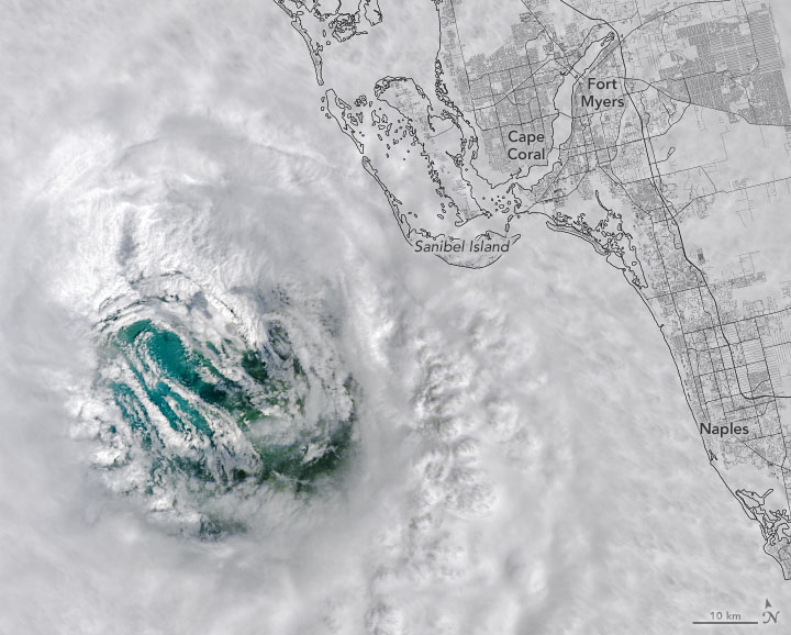
Satellite images offer insight into a storm's intensity. #Landsat 8 passed over Hurricane Ian’s eye as it approached southwest Florida.
The eye of a hurricane is a circular zone of fair weather at the storm’s center, surrounded by an eyewall of the strongest winds.
Satellite images offer insight into a storm's intensity. #Landsat 8 passed over Hurricane Ian’s eye as it approached southwest Florida.
The eye of a hurricane is a circular zone of fair weather at the storm’s center, surrounded by an eyewall of the strongest winds.
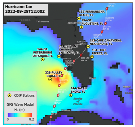
When #HurricaneIan made landfall in SW Florida, @CDIPBuoys measured significant wave heights. The largest individual wave was 52 feet (15.9 meters) at station 226-Pulley Ridge. This exceeded all previous events measured by CDIP along the Gulf Coast of Florida, dating back to 2007
Oct 1st - Larger View Loop: Freshwater flooding emptying out into the Gulf of Mexico along Southwest Florida's coastline. Also visible in this loop is a developing eddy in the Florida straits as kicked up sediment enters the Gulf Stream current.
Wondering what were some of the highest winds across West Central & SW Florida? Check out our preliminary wind report for #HurricaneIan 🌀🌬️:
https://t.co/IFhEDWOkZZ
#FLwx
A lot has happened since Hurricane Ian emerged off of Cuba as a Category 3 hurricane.
➡️ Briefly re-intensified north of Cuba
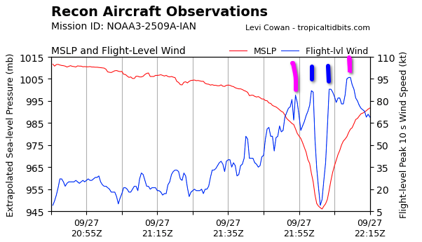
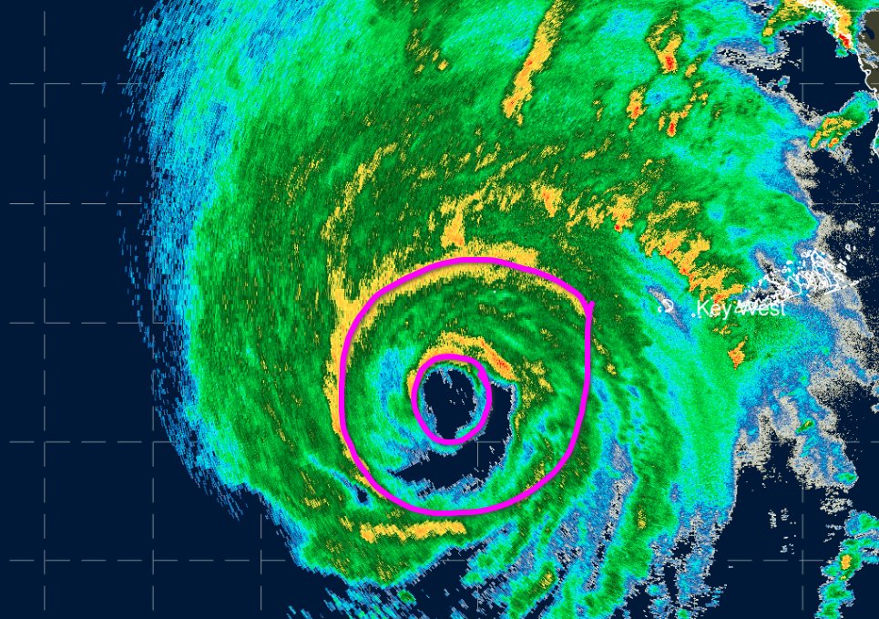
➡️ Temporarily reduced winds as an eyewall replacement cycle (ERC) occurred
➡️ Unexpected rapid intensification post-ERC to a high-end Cat 4 hurricane
#Ian is now at 155 mph, 1 mph shy of a cat 5. Only 4 US storms have made landfall that strong. It may be taking a similar track to Charley, but it’s no Charley. Ian’s eye is 40mi wide, hurricane winds are 75mi wide. Dwarfs Charley’s 5 mi eye & 30mi hurr winds. @WFLA 1/
@WeathermanCam It’s wild that a worst case scenario has unfolded for the SW Fl coast 😔 we’ve talked about it for years and now it’s happening. Sobering.
I can't overstate how serious the storm surge threat is in southwest Florida. #Ian will drive deadly surge into Cape Coral and Fort Myers, placing much of the area under water. If you live near the ocean in a surge zone, this is your last chance to leave...
New plane has penetrated Hurricane #Ian, and is finding evidence that the secondary wind max observed earlier is intensifying, and evolving into an outer eyewall that now has stronger winds than the inner eyewall, at least in the SE quadrant. Eyewall replacement cycle underway.