This is what it looks like when a community is designed with resiliency in mind. Strong building codes in a typhoon-prone location have mitigated loss:
One of the only times I remind people I have a PhD in computational neuroscience is when people without a neuroscience background say their model works "like the brain." In these cases, I put on my neuroscience hat, put on my PhD cloak, and say in my important voice: "No, your model is not behaving like the brain."
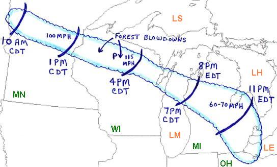
July 4, 1977:
Another potent derecho struck the Upper Midwest and Great Lakes regions. The MCS, which traveled from MN to northwest Ohio over ~15 hours, produced measured wind gusts up to 115 mph. Close to 2 million acres of forest in WI and MN were flattened.
#wxhistory
I'm keeping a close eye on much of MN later this PM for an explosion of potentially SEVERE T'Storms as a cool front slides east into a volatile atmosphere. Timing of the T'Storm development would be after 6pm. I will go LIVE in conditions warrant.
Excellent StormNet performance. Underwhelming look on most CAMs, only a 5% risk from SPC. Meanwhile, StormNet’s much higher risk verifies. This is a strong case for its future operational viability.
Hard to put my finger on one thing, I think it comes down a couple of things..
1) we trained the model to really sniff these higher end events out well. The tradeoff was that we occasionally get high probabilities for events that do perform, but don’t overperform like this one (last Wednesday, for example). It is far better for the model to “see” the ceiling than to miss the ceiling, as long as the model isn’t outputting high probabilities for complete busts. In our testing, there wasn’t a single overperforming tornado event/outbreak that didn’t have high probabilities. As a result of centering the custom architecture around this, StormNet is able to excel even with *very* difficult forecasts like April 24, 2025 which featured the significant Silverton, TX tornado.
2) just with high-quality ML in general.. I think StormNet is finding patterns in the data that we don’t understand yet. Our (meteorologists’) understanding of a tornadic environment and StormNet’s understanding of a tornadic environment overlap some, but they also diverge some.
We are working on v5, which we plan on releasing this winter. We expect another sizable jump in model capabilities, accessibility, and features.
SPC pushed back the enhanced risk more west and north, a lot of moving parts for the forecast on Wednesday, one of them will be the night/morning storms. Regardless we are gonna really have to watch this one, all severe hazards will be possible.
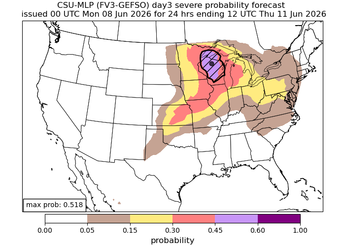
Elevated threat of tornadoes detected for Wednesday, June 10th, 2026.
See attached map for details.
This forecast initialized on Monday morning. Follow for future forecast updates.
Wednesday 👀
Will be interesting to see how this plays out, but as of now the models that are in range are pointing towards a rather sigificant severe weather outbreak in the upper midwest!
Elevated threat of tornadoes detected for Wednesday, June 10th, 2026.
See attached map for details.
This forecast initialized on Friday night. Follow for future forecast updates.
Not too often do you see a Day 6 Slight risk, but here we are.
All hazards possible on Wednesday across Minnesota, South Dakota, and North Dakota. Tornadoes will be possible. Next week looks active across the Northern Plains and Midwest!
SPC has upgraded Central #mnwx into central #wiwx to a slight right of severe weather for today! Main threats are hail and wind. The tornado threat is pretty low with this setup.
Elevated threat of tornadoes detected for Wednesday, June 10th, 2026.
See attached map for details.
This forecast initialized on Thursday night. Follow for future forecast updates.