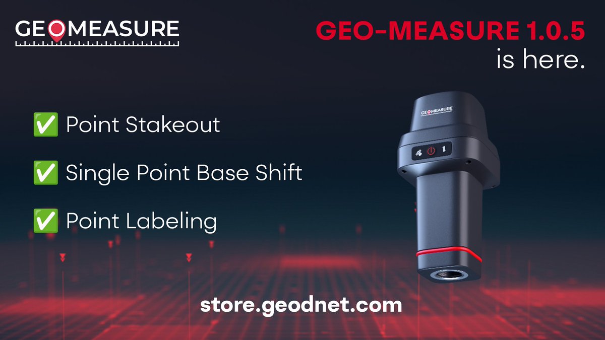
GEO-MEASURE 1.0.5 is here. And it's our biggest update yet.
✅ Stake Out: tap a point and walk right to it, centimeter accurate
✅ Single Point Base Shift: correct for known drift
✅ Point Labeling: custom names + colors on the map
Update now, the GEO-MEASURE just got more useful!
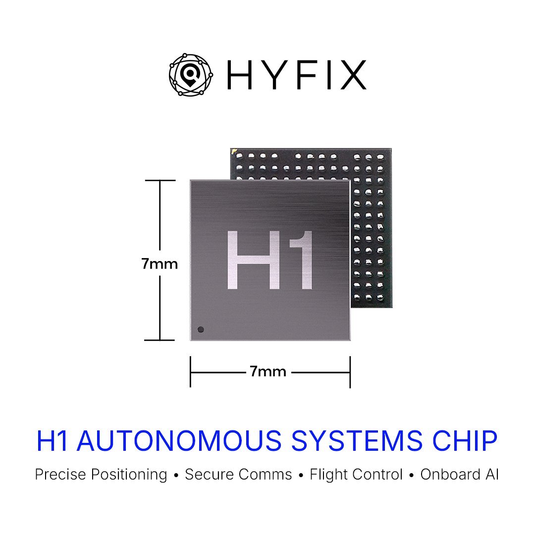
Small drones shouldn’t need a stack of fragile, foreign components to fly.
We built the alternative.
Introducing H1P: a fully integrated positioning, navigation, and open-compute module powered by the HYFIX H1 chip.
This is what changes:
• Centimeter-level positioning with RTK
• Dual-antenna GNSS + 800+ tracking channels
• LEO satellite compatibility for stronger, more resilient signals
• IMU sensor fusion for real-world environments, not lab conditions
• Onboard compute + flight control in one system
• PX4 compatible, built for developers
• 17×22mm form factor, drops into existing designs
What used to take multiple chips, modules, and vendors is now one unified system - fewer points of failure, more control, faster deployment, and stronger supply chain
Built in the U.S. for the next generation of autonomous systems.
See it live at AUVSI @ Xponential 2026 in Detroit - 5/11 - 5/14
Booth 34005
Proud of this one.
We just raised $15M to build American-made chips for drones and robotics.
For too long, the systems powering critical infrastructure have depended on fragile, foreign supply chains. We're rebuilding that foundation here in the U.S.
A lot more to come!
Building this drone because home security is still stuck on fixed cameras and human blind spots.
A camera sees what’s in front of it. It doesn’t check behind the fence, around the side yard, under the patio, or across a large property.
We wanted to build something that could actually move, respond, and check what you can’t see in real time.
So we started building GEO-SWARM: an autonomous security drone that can launch from its dock, inspect your property, and return home on its own.
This video is our prototype. Still early, but real.
Reserve yours now: https://t.co/xIotRHEa4j
New #Queectel#GNSS#RTK module #LG290P supporting multi-constellation and multi-band. It provides an unbelievable RTK performance (100% RTK fix) under heavy tree canopy paired with #GEODNET RTK correction service
💡Do you only think of traditional GPS when it comes to navigating the world?
This video explains how GEODNET can achieve unmatched precise positioning with:
✅Advanced GNSS technology
✅AI powered algorithm
✅RTK (Real-Time kinematics) technology
✅Web3 decentralized global infrastructure
For more information, follow us & visit our website!
#Web3 #GNSS #RTK #AI #AutomousDriving
According to @droneii, the future of drones in construction looks promising, and innovations such as autonomous drones, AI, and Building Information Modeling are expected to further revolutionize the industry. https://t.co/5GIdf2GvAz
Today’s presenters are Mike Horton, Dr. Kirstin Schauble, & Dr. Yibiao Zhao!
Join us live to hear their insights! https://t.co/pcddFLNR86
#GPSWorldWebinar#Sponsored by @geodnet
🔥 Another 100,000 $GEOD Tokens Burned!
❗️Burn means total $GEOD supply is permanently reduced. Accumulated burn is now 5,900,007.
👷♀️ Critical industries like agriculture, construction, drones, automotive and IoT find the GEODNET RTK service valuable today.
#GEOD#Crpto#Web3 #DePIN
Thank you for tuning in to today’s #GPSWorldWebinar!
If you have further questions for the speakers, their contact info is in the webinar console. This webinar will be available for viewing on-demand tomorrow here: https://t.co/wDd4hi2Bwg
#Sponsored by @geodnet
🪙Discover GEODNET Tokenomics!
🌏Join David Chen, Co-founder and Head of #Web3 Development at @geodnet , as he breaks down how our innovative #tokenomics system powers the world's largest #RTK network.
#DePIN#Crypto#Blockchain#GEOD
An army of #robots with @geodnet inside is preparing to land in a yard near you.
Train your @dogwifcoin and all the other dogs 🐶🐶
No Barking at #gnss robots whiles they are working!!
These little machines are usually friendly to all, but they are strong bulls 🐂🐂 when cutting thru weeds. 🎯🎯
Welcome Bahamas in the Caribbean to the growing list of uniquely-located @geodnet Global Stations!🌍
Our Global Backbone Stations provide revenue generating PPP, and PPP-RTK services by capturing every GNSS signal from every GNSS satellite simultaneously.
Have a remote island or Arctic location? Contact us 😉: https://t.co/imucX3d0Fw
#Web3 #RTK #PPP #GNSS #MinetheSky