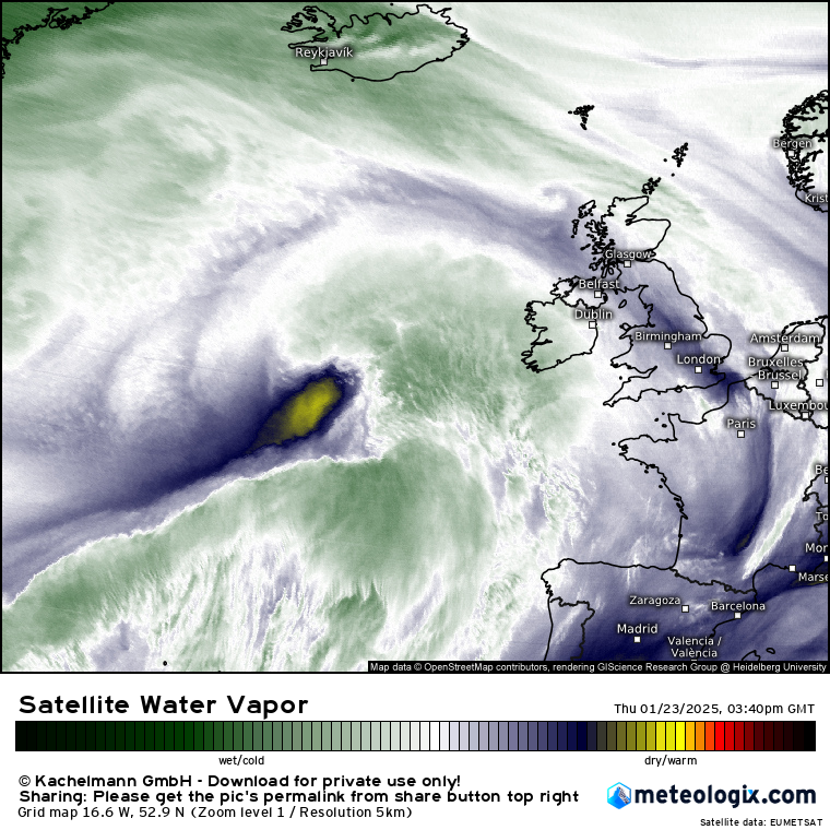
Smoke from a large fire in the Mourne Mountains of Down is visible from space this evening. Smoke from another large wildfire in Galloway Forest Park in western Scotland is also visible in this @eumetsat satellite imagery.
More - https://t.co/DWdTJi70Mf
@BelTel@irish_news
if michéal martin was accusing mary lou mcdonald of telling "lies" he would have said "ag insint bréag" PLEASE people the ginideach iolra is extremely clear and easy to understand
Although January 2025 was cooler than average for Ireland, overall Europe was warmer than average👇
👉 Globally it was the warmest January on record, 1.75°C above the pre-industrial level and the 18th month in the last 19 that surpassed 1.5°C above the pre-industrial level
🚨BREAKING: Former hostage: “Hamas offered to return me for nothing in exchange. Israel said no. So Hamas said we will drop them off at the border anyway (which they did)."
This is how much Israel cares about the hostages.
@LaoisWeather@SnowbieWx True, not exactly a whole load of new skyscrapers or anything at the airport. 😂 I would assume the anemometer would move too but not sure tbh.
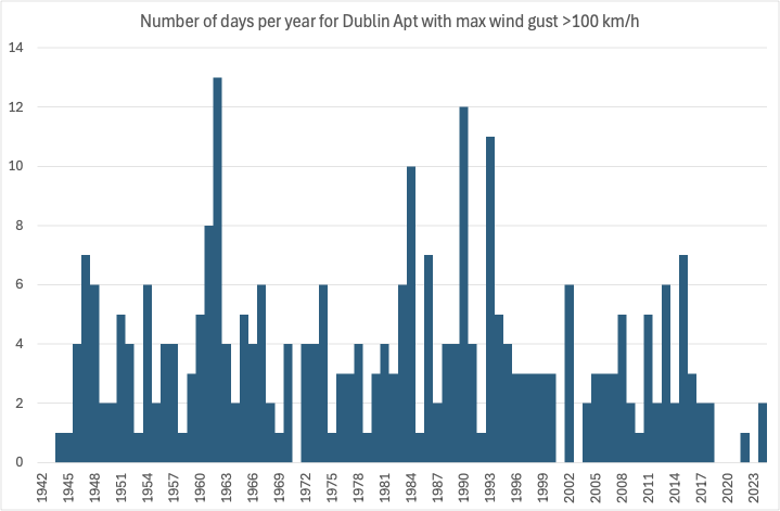
Interesting just how rare 100 km/h wind gusts have become in Dublin as Dublin Airport data shows. 4 of the most recent 6 years didn't have a single 100 km/h gust, exceptional in the record back to 1942.
Yet supposedly experts will say storms have increased here.
Classic Bullseye very dark purple centre beginning to appear in AIrmass imagery, showing intense Vorticity in Centre of #StormEowyn ,
The mass ascent on the forward side creating latent heat release, lowering tropopause , the strongest winds will form just to the S/SW of developing wrap around as the squeeze in winds occurs as they push down through the troposphere.
#StormEowyn looks as bad as i have seen in a very long time on imagery this evening.
Also some evidence of a double cloud head which is ominous sign seen in only the most intense developments and a sign of intense evaporation as the strong winds descend to the surface.
It is looking every bit as bad as feared this evening folks.
Shannon Radar already seeing the 1st sign of the rain arriving in SW Ireland
Very dry air from the tropopause (yellow) looks to be descending & intruding into the rear of #StormEowyn - this helps deepen the low rapidly tonight & may also aid in a sting jet forming - where winds from the jet stream are pulled down to the surface -bringing gusts over 100mph
#StormEowyn is now beginning to show the first ominous signs of cyclogenesis. The Airmass imagery shows a cloud head beginning to develop to the North of the wide baroclinic zone to the south of Newfoundland (highlighted below) This cloud head marks the 1st sign that a deepening low pressure is under cloud mask. The Low will cross through the Jet Core tonight and move into the highly divergent left exit region on Thurs Morning.
The 12Z Models have maintained the track and depth of the 00Z Run. The 12Z GFS Ensemble showing excellent agreement to support the earlier 06Z ECMWF Ensemble.
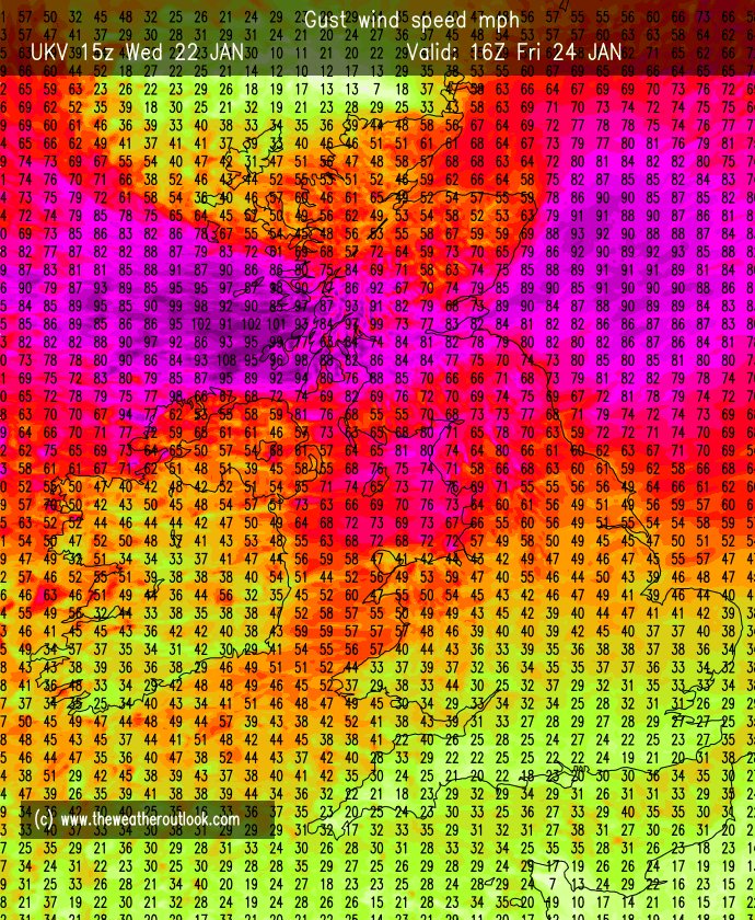
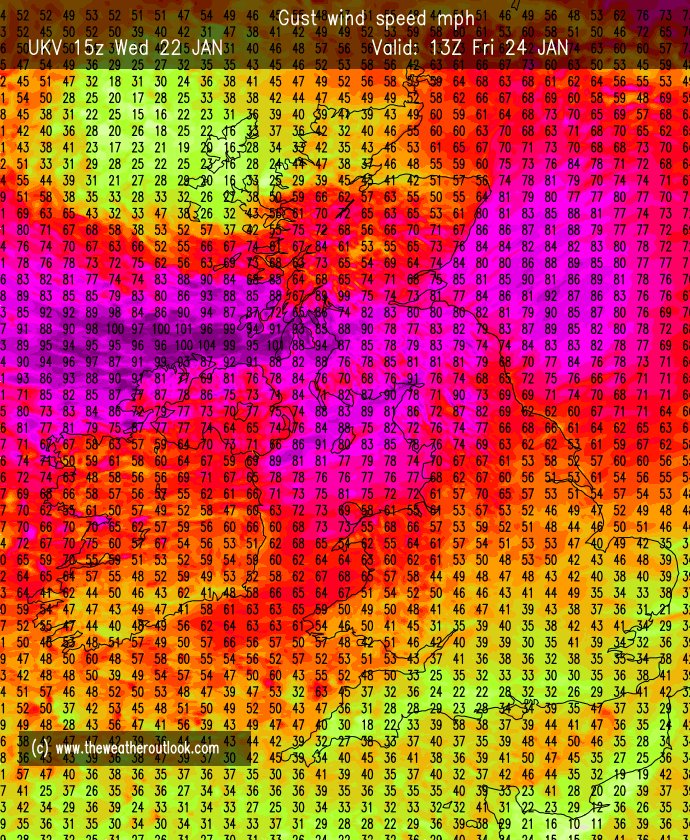
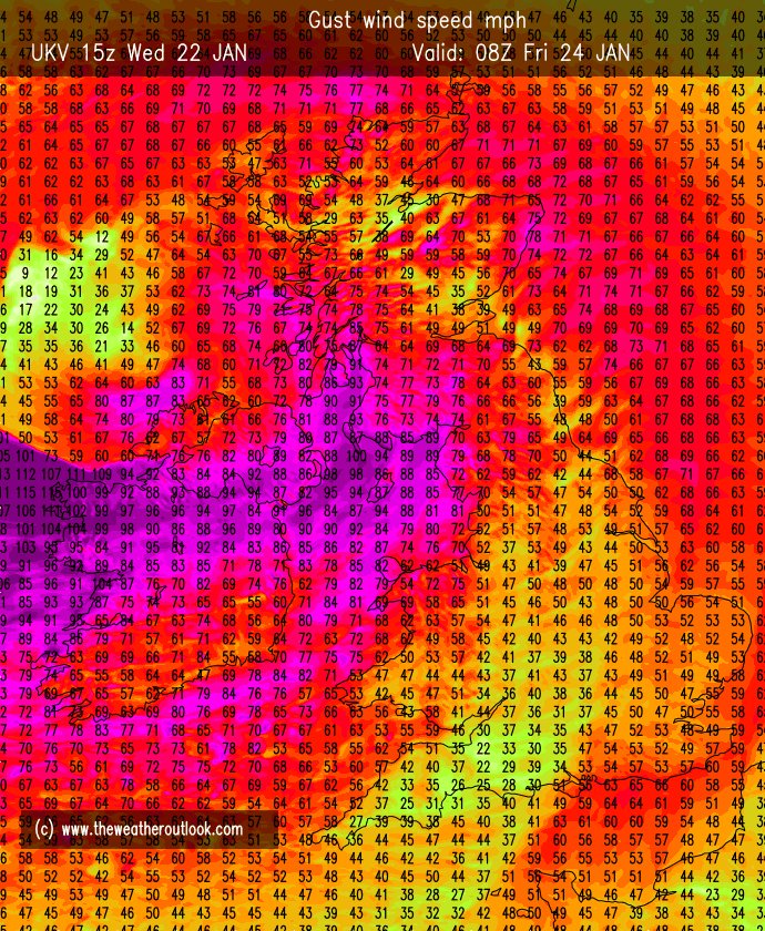
It must be reiterated again that #StormEowyn is likely to be one of the strongest storms to hit Ireland in many many years with wind gusts to 90-95mph even inland to the East of Galway Bay, and winds gusting to over 100mph along the coast, perhaps as high as 110mph along places like Mace Head.
Risk has increased for strong 90mph winds through the Central Belt of Scotland and winds to 100mph around the North Channel, Solway Firth. Winds also higher in parts of SW Scotland & extending slightly further north into the area north of Glasgow/Edinburgh.
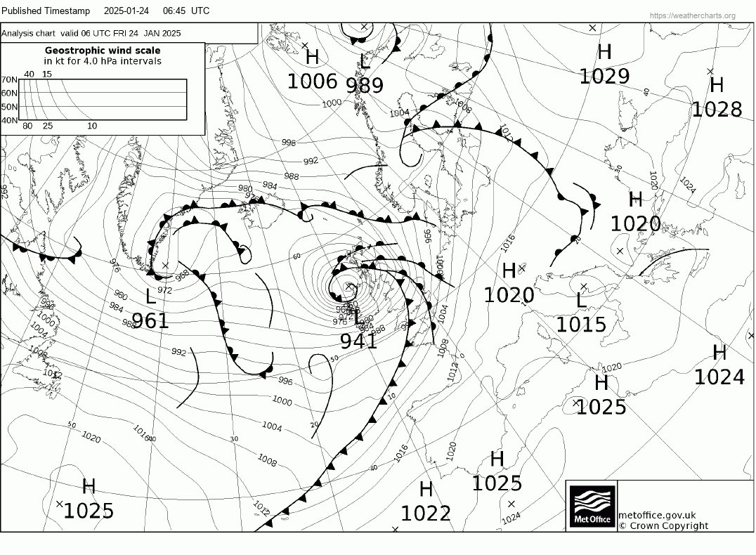
Peak depth down to around 938mbs as the storm slams into the British Isles, likely to brush close to Belmullet Island.
Gusts in the Isle of Man and around the Irish Sea will be around 85-90mph, Inland gusts over Northern Ireland to 90mph.
I see nothing to downplay any aspects of this storm in tonight's guidance. I expect RED Danger to life warnings to be issued on Thursday Morning for parts of SW Scotland, Northern Ireland, Northern Irish Sea coasts.
#StormEowyn will be an extremely dangerous storm. We are very fortunate to have the NOAA Hurricane Hunters in Shannon where they will be flying NOAA42 KERMIT into #StormEowyn to gather extremely rare and extremely valuable research into this storm over the next couple of days. Currently in Shannon it will be flying research missions to help our understanding of such powerful cyclogenesis. I look forward to seeing their valuable research.
The Global Climate Highlights 2024 report is now online.
Delve in the analysis and access all the charts, information, and data on temperature, sea ice, precipitation, and greenhouse gas concentrations. Explore the data that defined 2024: https://t.co/s3JeRjZUyg
#C3S#GCH2024