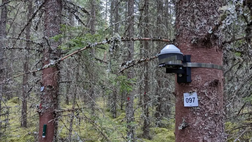
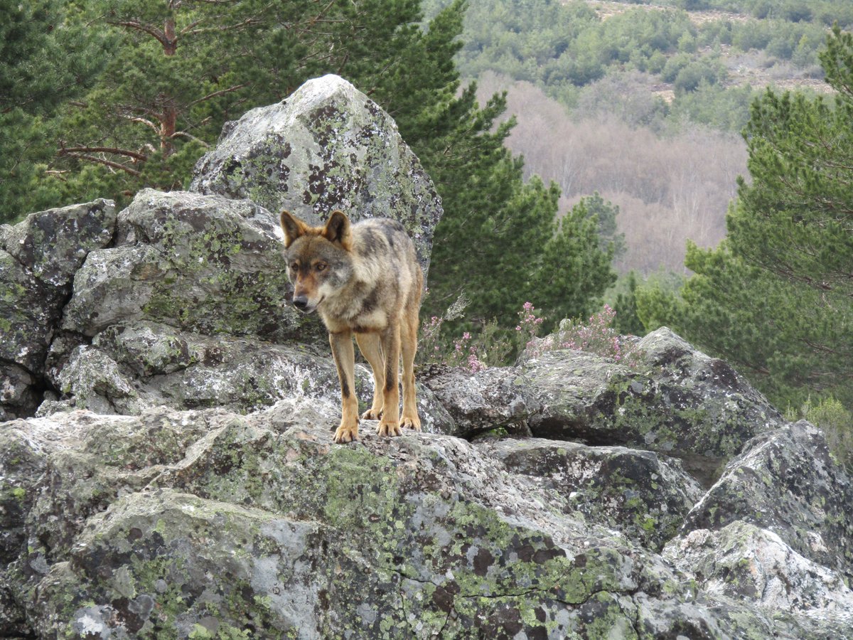
A few years ago, we started asking if the adaptation of Iberian wolves to anthropogenic landscapes could be associated with ancient introgression from domestic dogs. In our recently accepted paper at @genomeresearch we provide new insights: https://t.co/CiB6wRNXJ2 🐺🧬🐶
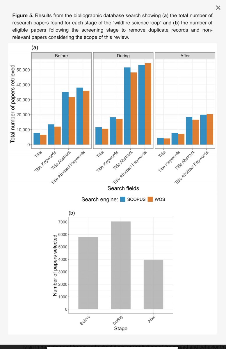
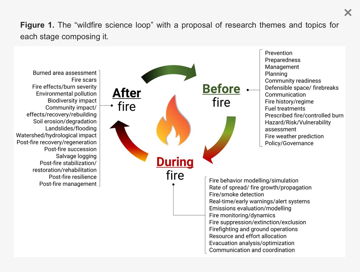
🚨 New study! Post-fire research is 46% less studied than “before” fires & 77% less than “during.” @Fire_MDPI@SeverusPt
We propose a roadmap to close this gap, focusing on recovery, resilience & adaptive management.
🔗 https://t.co/YgCacwQuhv
#WildfireScience#Resilience
[PAQUETE 📦] - 🌦️ ¿Necesitas datos meteorológicos e hidrológicos para tus análisis? El paquete {climate} facilita la descarga automatizada de información de repositorios públicos como OGIMET, la Universidad de Wyoming, el Instituto Polaco de Meteorología y la NOAA. 📊
📍 Además, puedes buscar coordenadas geográficas de cada observación y calcular distancias a las estaciones más cercanas. Ideal para investigadores, analistas y apasionados del clima. 🌍
🚀 ¡Haz que tus flujos de trabajo sean más eficientes y precisos!
🌐 https://t.co/5phN30TtHo
✍🏼 @bartoszmeteo
#RStats #RStatsES #Rtips #DataScience @[email protected]
📖Published📖
In our new Research Article, Hu et al. shed light on the potential of deep learning methods in the domain of species distribution modelling, providing valuable insights for future research and applications in this field 👇
https://t.co/X8yqrsfvjO
Last contribution from the Spatial Biology Lab. It highlights how packages can work together to expand analyses in each step of a modelling workflow.
Ecography - Wiley Online Library https://t.co/iyMUJjkdaS
🌲Would you like to study climate effects on forests by remote sensing? We have an open three-year #postdoc#position within #remotesensing of forests! Study the "pulse" of trees using RS and dendrometers.
Learn more and apply here 👉 https://t.co/Jl0OGG4I7k
Setting a good background region for SDM/ENM can be tricky when survey effort is heavily biased, as it often is. I've implemented some new approaches in #Rstats package fuzzySim. Anyone up for trying them out? https://t.co/ZqLaTIIckr #gischat#ecology#biogeography#macroecology
In our new paper in @NatureClimate co-led by Chantelle Burton (@MetOffice_Sci) and @SeppeLampe (@VUBrussel), we show that global burned area patterns are increasingly explained by climate change. 🧵
https://t.co/gpOrvlPZih
⚠️ Big news! ⚠️ So excited to share that our article just been published @NatureComms! 🥳 How does multifunctionality shape ecosystems? We propose and validate a framework that integrates various types of biotic interactions! 🌱🦋🍄 check it out here:
https://t.co/yK8jMIa6jx
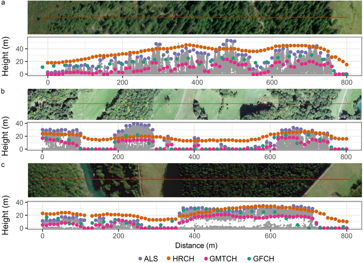
🚨 Paper alert! Do you work with global forest canopy height maps?🌲🌳 Check out our latest work led by Vítězslav Moudrý, comparing 3 global maps derived from @GEDI_Knights data🛰️ We found accuracy gaps that could impact biodiversity estimation https://t.co/XYfET2IBA7
🔥New paper out in Science!!🔥 @ScienceMagazine
We found that a third of the seed dispersers and interactions face potential extinction, in Europe 🌿🌳🐦⬛🦆🌍
This was an incredibly challenging (and rewarding!) chapter of my PhD thesis! #seeddispersal
https://t.co/QM55D2ziiu
We are hiring! We offer a 2-year postdoc position to develop our research line in ecosystem mapping and monitoring with vegetation data and remote sensing. Contact us before 31 October 2024! @BorjaJimAlf@ialeEurope@_AEET_@EcosistemasAEET
See details👉: https://t.co/OOTYhswmuv
O projecto SeverusPT preparou um relatório preliminar com estatísticas atualizadas sobre o impacto dos incêndios de 2024 -"Análise da área ardida em Portugal Continental no ano de 2024" - Visitem o link: https://t.co/zaDdkOxivi
👇
Proud to share that I’ve published the second paper from my PhD in @SciReports (https://t.co/X6pF4Uj07B). My goal was to assess the complementarity of two ecosystem-scale #EBVs (Essential Biodiversity Variables) derived from the same source (#Landsat) for ecosystem monitoring.
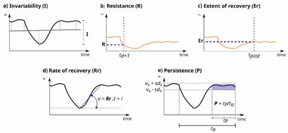
Early spectral patterns can help identify longer recovery in post-fire forests. My 2nd PHD paper (JUST PUBLISHED & OPEN SOURCE) looks at the patterns of structural recovery after fire in British Columbia using early (<5yrs) of spectral data. 🛰️
https://t.co/JKqPE7CbN9
👀Detailed and low latency #wildfire info. Aim to include as layer in Google maps.
6-band multispectral infrared (IR) instruments, over 50 satellites when constellation complete, ~20min revisit. Pathfinder launch in 2025, 3 planned for launch in 2026 to initiate constellation.





![estacion_erre's tweet photo. [PAQUETE 📦] - 🌦️ ¿Necesitas datos meteorológicos e hidrológicos para tus análisis? El paquete {climate} facilita la descarga automatizada de información de repositorios públicos como OGIMET, la Universidad de Wyoming, el Instituto Polaco de Meteorología y la NOAA. 📊
📍 Además, puedes buscar coordenadas geográficas de cada observación y calcular distancias a las estaciones más cercanas. Ideal para investigadores, analistas y apasionados del clima. 🌍
🚀 ¡Haz que tus flujos de trabajo sean más eficientes y precisos!
🌐 https://t.co/5phN30TtHo
✍🏼 @bartoszmeteo
#RStats #RStatsES #Rtips #DataScience @rstats@a.gup.pe](https://pbs.twimg.com/media/GgmnT0eXUAAItUs.jpg)









![estacion_erre's tweet photo. [PAQUETE 📦] - 🌦️ ¿Necesitas datos meteorológicos e hidrológicos para tus análisis? El paquete {climate} facilita la descarga automatizada de información de repositorios públicos como OGIMET, la Universidad de Wyoming, el Instituto Polaco de Meteorología y la NOAA. 📊
📍 Además, puedes buscar coordenadas geográficas de cada observación y calcular distancias a las estaciones más cercanas. Ideal para investigadores, analistas y apasionados del clima. 🌍
🚀 ¡Haz que tus flujos de trabajo sean más eficientes y precisos!
🌐 https://t.co/5phN30TtHo
✍🏼 @bartoszmeteo
#RStats #RStatsES #Rtips #DataScience @rstats@a.gup.pe](https://pbs.twimg.com/media/GgmnT0fXQAAzTxF.jpg)