

Top Tweets for #TROPiCS

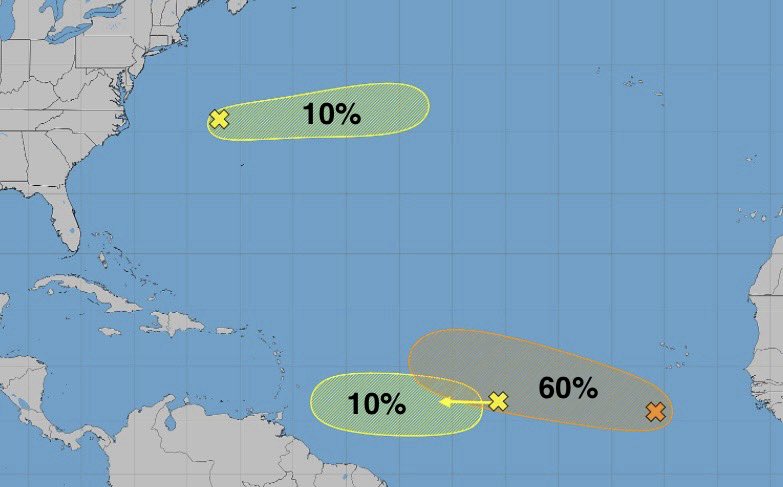
The tropics are more active now than we've seen this season. In the Atlantic, the disturbance closest to Africa is the only one that looks like it has a good shot at tropical development as of Monday evening. #tropics


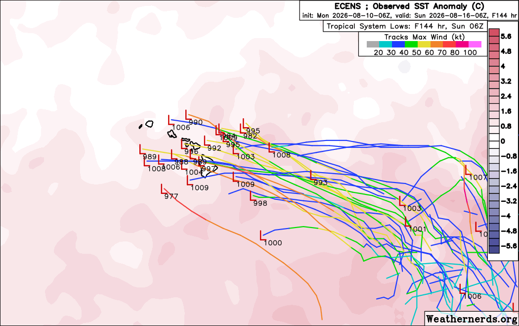


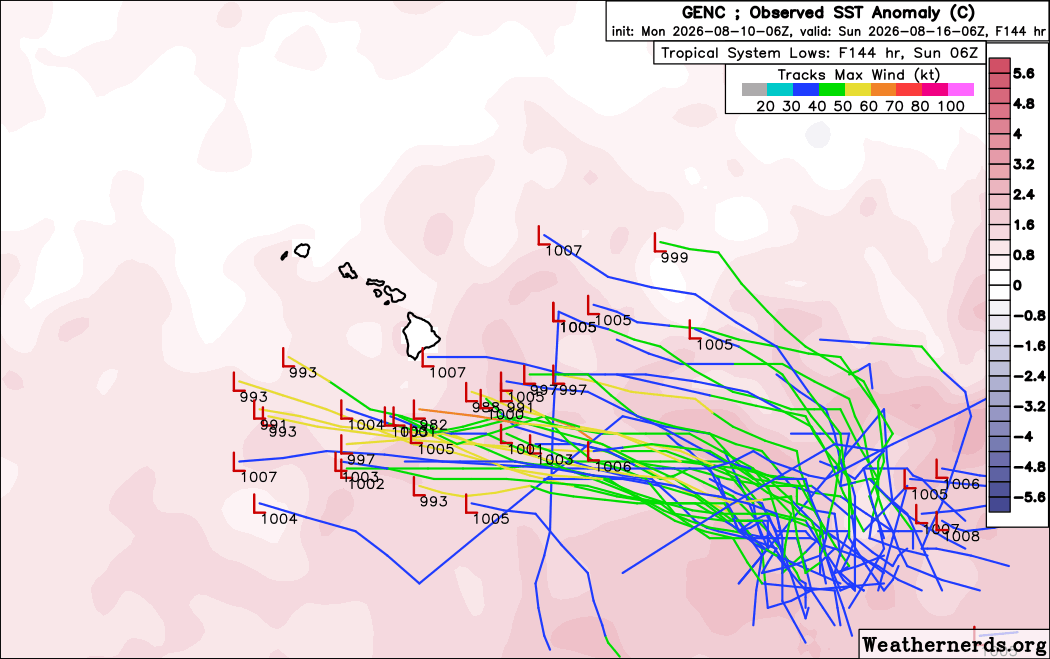

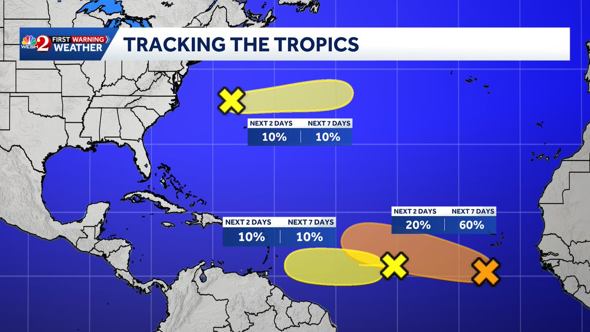

Tropics are heating up. which around this time of the year is par for the course. Best chance in next 7 days of forming into a named storm would be in the orange highlighted area. #tropics #wx #tropicalstorm #clt


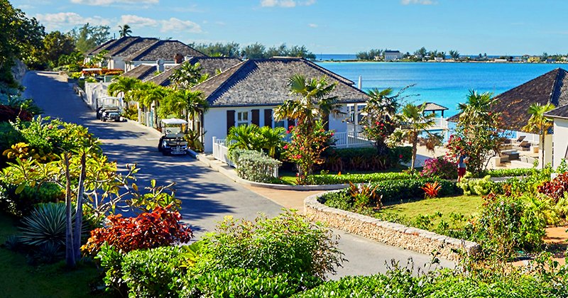
French Leave Resort is as pretty as a postcard. 🌺🌴🌊 https://t.co/ZQ9GcFOxmy
#bahamas #vacation #luxurytravel #tropics #beach

MDR 🍋 losing steam. Subtropical 🍋 is holding steady but still very low chances. The one to watch is the MDR 🍊which is up to 60%. Could bring some weather to the Leeward islands late next weekend. #Tropics #Tropicalwx


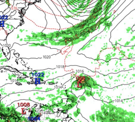

#tropicalupdate august 10 2026 #Dolphin is gone, TD #Peilou spinning out in the ocean, same as #15W, Tropical Storm #ChanHom nearing #Japan, #90W well who knows why it is there, and #93c has a medium chance to develop in the next few days #tropics #tropicswx

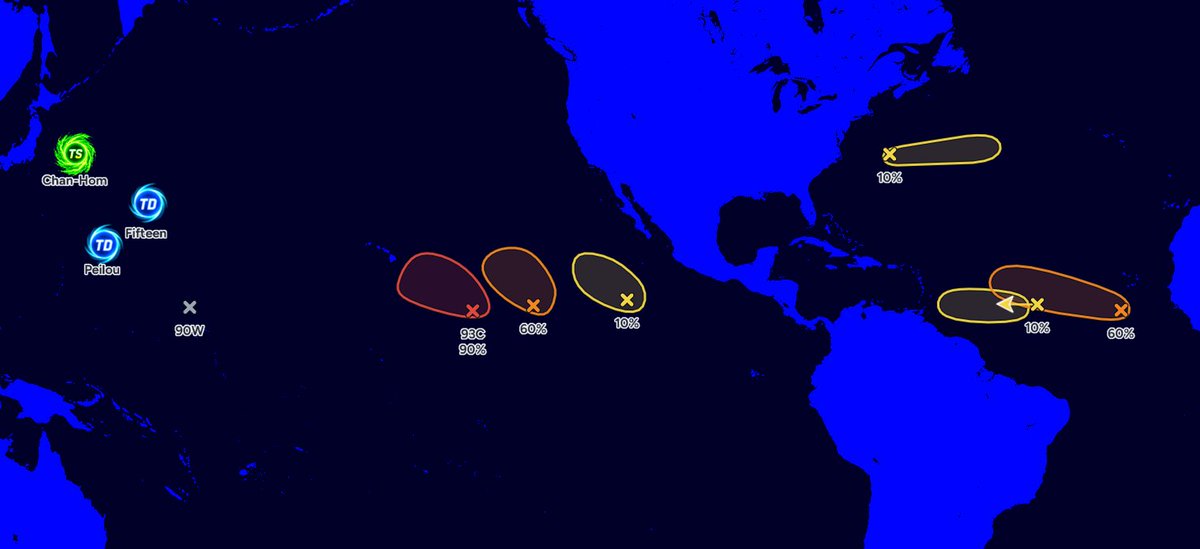


🌀🌴 CARIBBEAN #TropicalUpdate🌴/ #Tropics 🌀
Issued Monday, August 10, 2026
— 5:00 AM Dominica Time
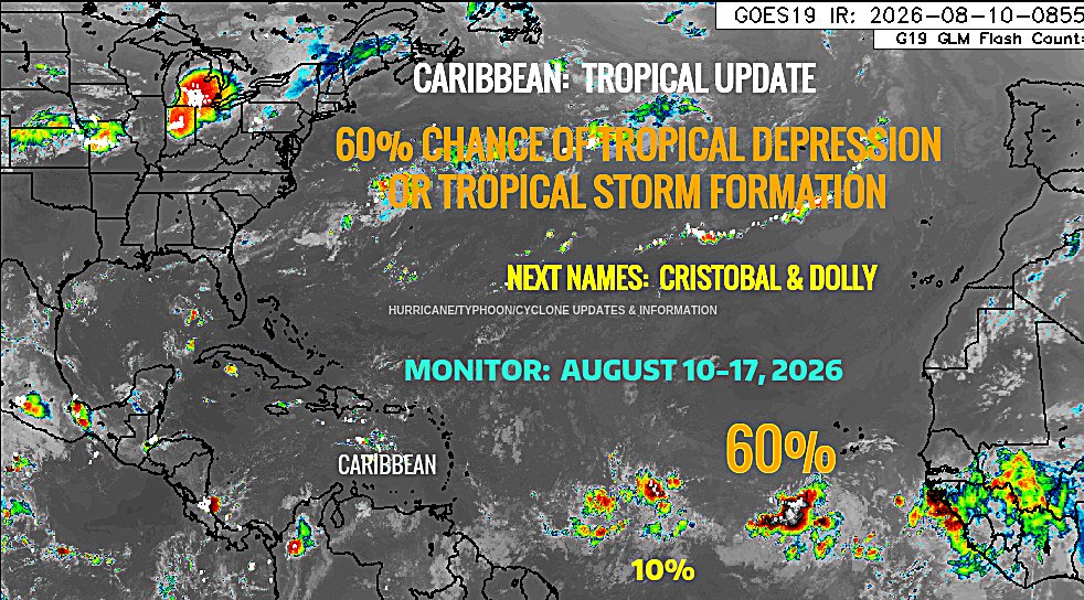
The National Hurricane Center (NHC) in Miami is monitoring two areas of interest in the tropical Atlantic as two tropical waves have emerged from the West African coast.
Both tropical waves are being monitored for the potential development of a TROPICAL DEPRESSION or TROPICAL STORM during the upcoming week, August 10-17, 2026.
🌀 AREA OF DISTURBANCE #1 — 10%
The first area of disturbance, #1, currently has a 20% chance of TROPICAL DEPRESSION or TROPICAL STORM formation during the upcoming week, August 10-17, 2026.
🌀 AREA OF INTEREST #2 — 60%
The second area of interest, #2, currently has a 60% chance of possible TROPICAL DEPRESSION or TROPICAL STORM development during the upcoming week, August 10-17, 2026.
🌴 #CARIBBEAN INTERESTS SHOULD MONITOR
Residents and interests throughout the Caribbean should continue monitoring both tropical waves, particularly as they move westward across the tropical Atlantic.
At this time, neither disturbance represents an immediate threat to any specific Caribbean island. However, conditions can change, and tropical systems can organize relatively quickly once they encounter a more favorable environment.
The next names on the 2026 Atlantic tropical cyclone naming list are:
🌀 CRISTOBAL
🌀 DOLLY
Residents throughout the Caribbean should therefore remain aware of the possibility that one of these disturbances could become the next named tropical system in the Atlantic Basin if sufficient organization occurs.
🌬️ ENVIRONMENTAL CONDITIONS
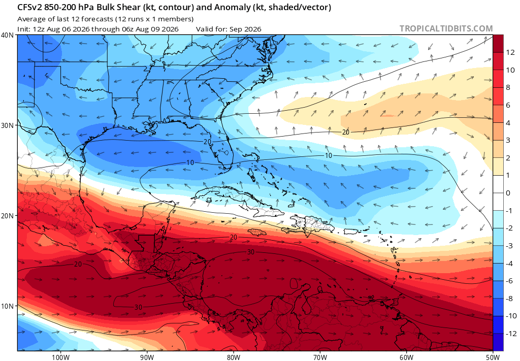
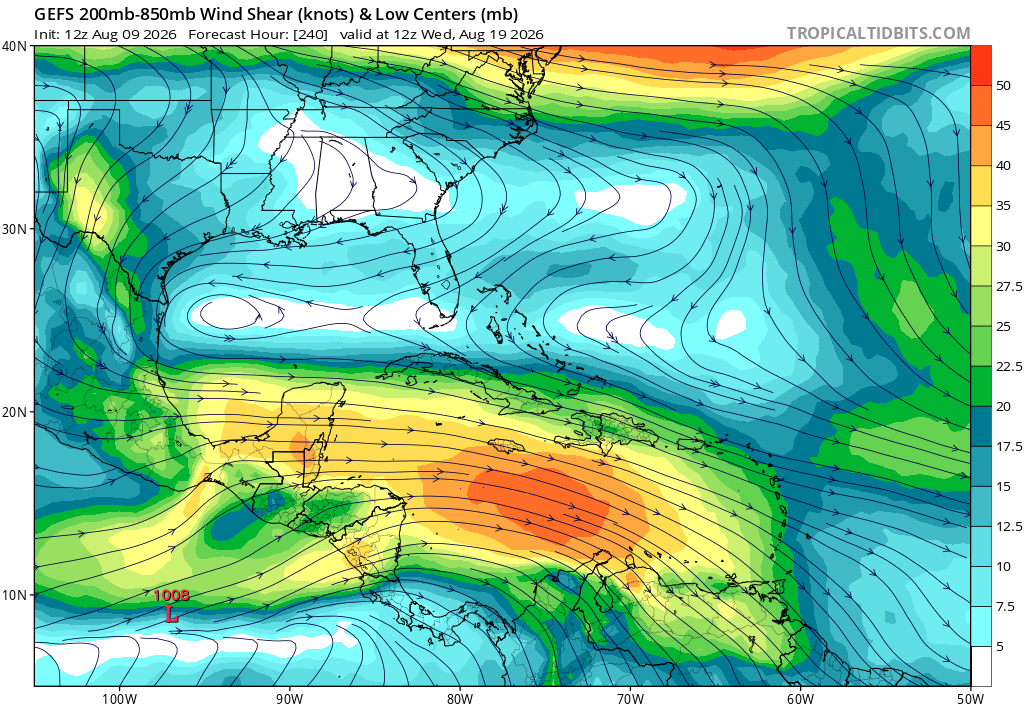
The tropical Atlantic continues to feature strong vertical wind shear, creating an unfavorable environment for significant tropical development. However, there may be a window of opportunity for either one or both tropical waves to become better organized if environmental conditions become more favorable during the coming days.
The current development probabilities are projections and can change as additional meteorological data become available.
🌀 🌀🌴 CONTINUE TO MONITOR 🌴🌀
Follow updates from the National Hurricane Center-Miami and Hurricane/Typhoon/Cyclone Updates & Information for additional information.
🌀🌴 STAY ALERT. STAY INFORMED. STAY PREPARED. 🌴🌀
Respectfully,
Roshin
🌀 #HAWAII #TropicalUpdate / #93C
— #Invest93C #Tropics
🕐 HAWAII TIME: 5:02 PM HST
📅 DATE: Sunday, August 9, 2026
━━━━━━━━━━━━━━━━━━━━
🌀 INVEST 93C — CENTRAL PACIFIC OCEAN
⚠️ CURRENT STATUS: Tropical disturbance / Invest 93C
📈 FORMATION CHANCE: 90% — HIGH
⏱️ FORMATION PERIOD: Next 7 days
🏷️ POTENTIAL NAME: TROPICAL STORM LALA
━━━━━━━━━━━━━━━━━━━━
🌀 CURRENT SITUATION
Invest 93C is a tropical disturbance located over the Central Pacific Ocean and is being closely monitored for possible tropical-cyclone development.
The disturbance currently has a 90% chance of developing into a tropical cyclone during the next seven days, placing it in the HIGH category for formation.
93C remains an invest/disturbance and has not yet been classified as a tropical depression or tropical storm.
━━━━━━━━━━━━━━━━━━━━
�� CURRENT STATUS
🌀 Designation: Invest 93C
📈 Formation Probability: 90% — HIGH
💨 Maximum Sustained Winds: Not verified in the latest available official information
📉 Minimum Pressure: Not verified
🧭 Movement: Not verified
📍 Exact Coordinates: Not verified
━━━━━━━━━━━━━━━━━━━━
🌀 POTENTIAL DEVELOPMENT
Conditions will be closely monitored for additional organization of the disturbance.
Should Invest 93C develop into a tropical depression and subsequently reach tropical-storm strength, the next available Central Pacific name is:
🌀 LALA
Pronunciation: LAH-lah
━━━━━━━━━━━━━━━━━━━━
🌺 HAWAII THREAT ASSESSMENT
⚠️ CURRENT THREAT TO HAWAII: NOT DETERMINED
There is currently no indication that Hawaii is under a tropical-cyclone watch or warning because of Invest 93C.
The 90% formation probability refers to the likelihood that the disturbance will become a tropical cyclone — it does not mean there is a 90% chance of a Hawaii landfall or direct impact.
The eventual threat to the Hawaiian Islands will depend on:
• Development and organization of the system
• Steering currents across the Central Pacific
• Forward movement and track
• Wind shear
• Ocean temperatures
• The system's eventual intensity
━━━━━━━━━━━━━━━━━━━━
🚨 PREPAREDNESS
Residents and visitors across the Hawaiian Islands should remain weather-aware and continue monitoring official information as Invest 93C develops.
No emergency preparations for a direct Hawaii impact are warranted solely from the current information.
However, because tropical systems can chĺange in organization, intensity, and track, residents should remain prepared to act if future forecasts indicate an increasing threat.
━━━━━━━━━━━━━━━━━━━━
🌀 BOTTOM LINE
INVEST 93C IS A SIGNIFICANT TROPICAL DISTURBANCE IN THE CENTRAL PACIFIC WITH A 90% CHANCE OF TROPICAL-CYCLONE FORMATION DURING THE NEXT 7 DAYS.
If the system develops and reaches tropical-storm strength, it would be named LALA.
HAWAII IS NOT CURRENTLY UNDER A TROPICAL-CYCLONE WATCH OR WARNING FOR INVEST 93C.
Respectfully,
Roshin
Residents should continue monitoring the Central Pacific Hurricane Center + National Hurricane Center-Miami + Hurricane/Typhoon/Cyclone Updates & Information for subsequent advisories.
━━━━━━━━━━━━━━━━━━━━
🌀


Ok, we have a lot going on in the tropics....
Area #1:
- Next 48 hours: 0%
- Next 7 days: 20%
Area #2:
- Next 48 hours: 0%
- Next 7 days: 50%
Area #3: This does not pose a threat to the United States.
- Next 48 hours: 10%
- Next 7 days: 10%
#tropics #atlanticocean

New 🍋 in the subtropics. Small window til about Wed. DeepMind doesn’t acknowledge it or the MDR 🍋 where its chances drop closer to Caribbean. Eastern MDR 🍊now at 50%. Models are more bullish on this one. ECENS does like the subtropical 🍋 a little. #Tropics #Tropicalwx


#TROPICS SUN PM UPDATE
Watching 3 areas in the Atlantic this week
> Area in open Atlantic has a Low Development Chance as it moves west
> Area near Africa has a Medium Development Chance and could be a TD late week
> NEW Area west of Bermuda has a Very Low Development Chance
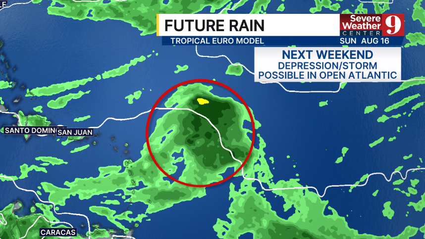
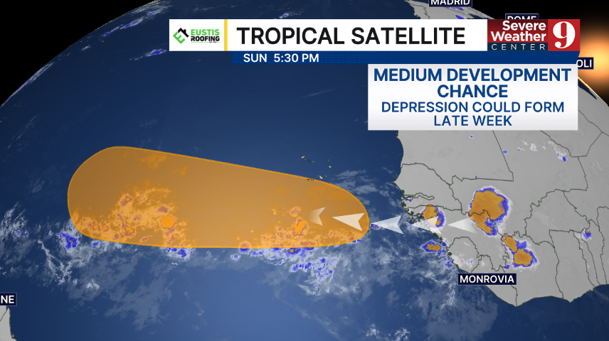
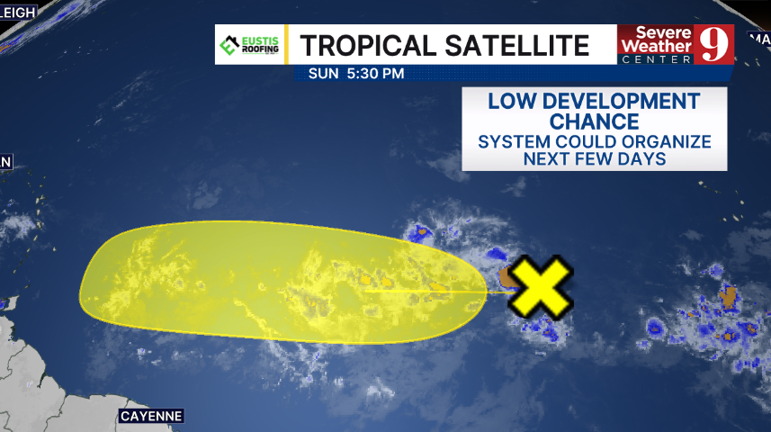


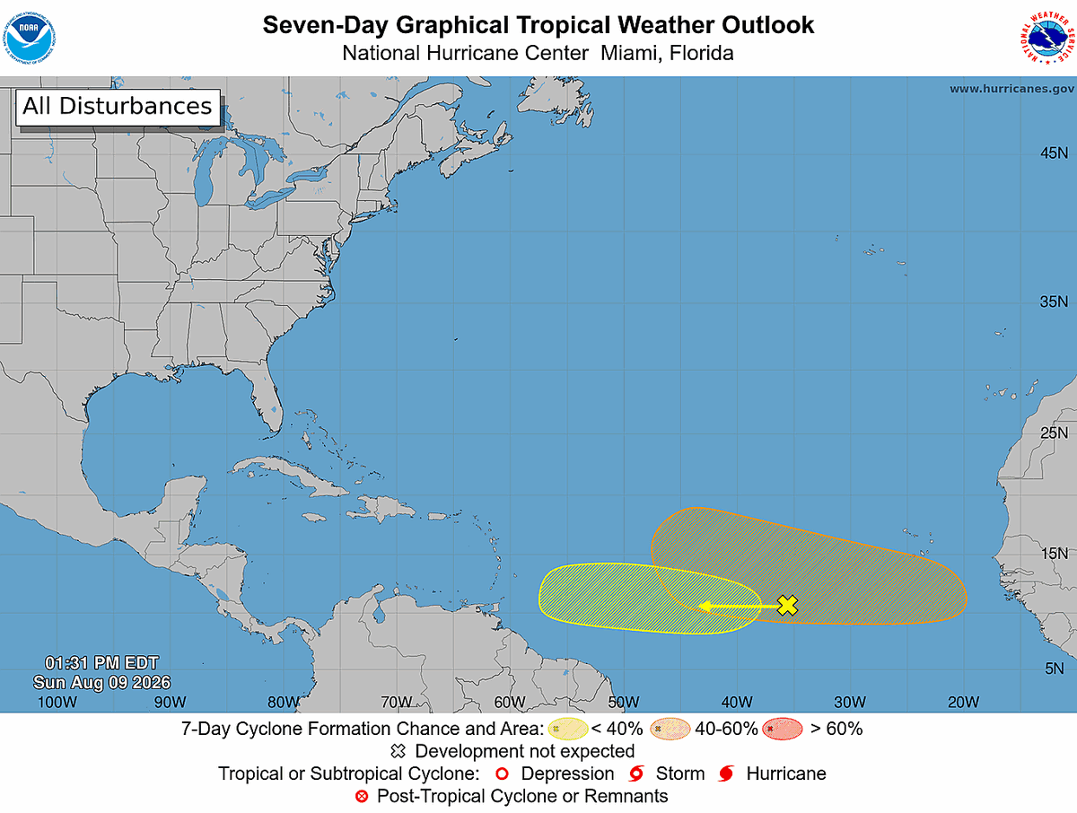

NHC has two Atlantic disturbances on watch — one at 20%, one at 50% development odds. I walk through what GFS, Euro, AI models & 50-60kt shear mean for their chances. Full breakdown: https://t.co/NjzTC0rI3y #hurricaneseason2026 #tropics
🌀🌴 CARIBBEAN #TropicalUpdate🌴/ #Tropics 🌀
Issued Sunday, August 9, 2026
— 2:00 PM Dominica Time
The National Hurricane Center (NHC) in Miami is monitoring two areas of interest in the tropical Atlantic as two tropical waves have emerged from the West African coast.
Both tropical waves are being monitored for the potential development of a TROPICAL DEPRESSION or TROPICAL STORM during the upcoming week, August 9-16, 2026.
🌀 AREA OF DISTURBANCE #1 — 20%
The first area of disturbance, #1, currently has a 20% chance of TROPICAL DEPRESSION or TROPICAL STORM formation during the upcoming week, August 9-16, 2026.
🌀 AREA OF INTEREST #2 — 50%
The second area of interest, #2, currently has a 50% chance of possible TROPICAL DEPRESSION or TROPICAL STORM development during the upcoming week, August 9–16, 2026.
🌴 #CARIBBEAN INTERESTS SHOULD MONITOR
Residents and interests throughout the Caribbean should continue monitoring both tropical waves, particularly as they move westward across the tropical Atlantic.
At this time, neither disturbance represents an immediate threat to any specific Caribbean island. However, conditions can change, and tropical systems can organize relatively quickly once they encounter a more favorable environment.
The next names on the 2026 Atlantic tropical cyclone naming list are:
🌀 CRISTOBAL
🌀 DOLLY
Residents throughout the Caribbean should therefore remain aware of the possibility that one of these disturbances could become the next named tropical system in the Atlantic Basin if sufficient organization occurs.
🌬️ ENVIRONMENTAL CONDITIONS
The tropical Atlantic continues to feature strong vertical wind shear, creating an unfavorable environment for significant tropical development. However, there may be a window of opportunity for either one or both tropical waves to become better organized if environmental conditions become more favorable during the coming days.
The current development probabilities are projections and can change as additional meteorological data become available.
🌀 🌀🌴 CONTINUE TO MONITOR 🌴🌀
Follow updates from the National Hurricane Center-Miami and Hurricane/Typhoon/Cyclone Updates & Information for additional information.
🌀🌴 STAY ALERT. STAY INFORMED. STAY PREPARED. 🌴🌀
Respectfully,
Roshin


@BobbiStorm @NewThor There is a narrow pathway, if MDR systems can get above about 22*N without recurving, there looks to be an area of not-unfavorable shear. Threading a needle to be sure, but EC Florida and points north, there is a pathway to an MDR hurricane, even if narrow. #tropics

Development chances continue to tick up on the 2nd tropical wave
#tropics

Four Points by Sheraton Caguas Real Hotel exists as a true tropical oasis. ☀️🌴💦
https://t.co/dexG0P2hoU
#puertorico #vacation #familytravel #tropics

Last Seen Hashtags on Sotwe
omegle
Seen from United States
teeNager
Seen from Netherlands
كتكوتة
momsonn
Seen from United States
renoafterdark
Seen from Indonesia
momson #teenagee #omegle () +filter:native_video
Seen from United States
부커
Seen from Korea
รับงานบางขุนเทียน
Seen from Thailand
おむつ
Seen from Singapore
gaybocil
Seen from Indonesia
Trends for you
Most Popular Users

Elon Musk 
@elonmusk
241.2M followers

Barack Obama
@barackobama
119.1M followers

Cristiano Ronaldo
@cristiano
112.9M followers

Donald J. Trump
@realdonaldtrump
111.8M followers

Narendra Modi
@narendramodi
107.1M followers

Rihanna
@rihanna
98.3M followers

NASA
@nasa
92.3M followers

Justin Bieber
@justinbieber
91.5M followers

KATY PERRY
@katyperry
89.1M followers

Taylor Swift
@taylorswift13
83M followers

Lady Gaga
@ladygaga
74.5M followers

Virat Kohli
@imvkohli
72M followers

Kim Kardashian
@kimkardashian
70.5M followers

YouTube
@youtube
68.8M followers

Neymar Jr
@neymarjr
64.9M followers

Bill Gates
@billgates
64.6M followers

The Ellen Show
@theellenshow
62.4M followers

Selena Gomez
@selenagomez
62.1M followers

CNN
@cnn
61.8M followers

X
@x
60.8M followers