Top Tweets for #WorldView2

Mapping Dissolved Organic #Carbon and Organic #Iron by Comparing #DeepLearning and Linear Regression Techniques Using #Sentinel2 and #WorldView2 Imagery (Byers Peninsula, Maritime Antarctica)
✍️ Susana del Carmen Fernández et al.
🔗 https://t.co/yBKtYFDCYu


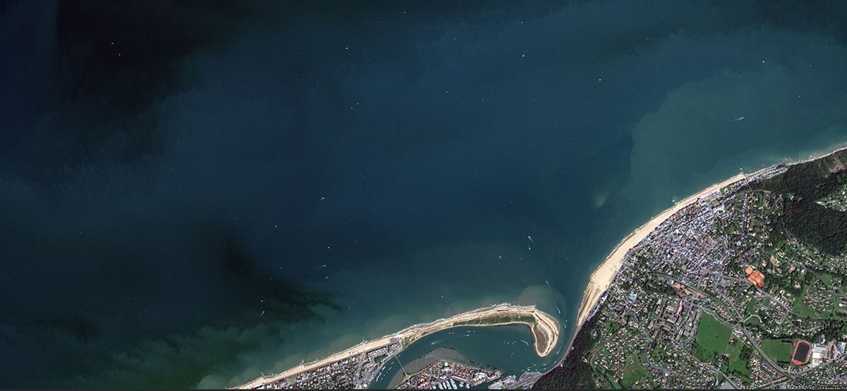
This cropped scene captured oby #WorldView2 on 23 Aug 2020, reveals a glimpse of the French Atlantic coast in #Normandy. Port Guillaume's bustling ship traffic is vividly depicted in this Very High Resolution (VHR) image, showcasing the potential for enhanced maritime surveillance when combining high-resolution optical and radar data. 🛰️🌊
The Worldview-1 to -4 missions are part of @ESA's TPM programme! Explore more: https://t.co/GG6vsEKGi5
📸@Maxar @EUSPACEIMAGING

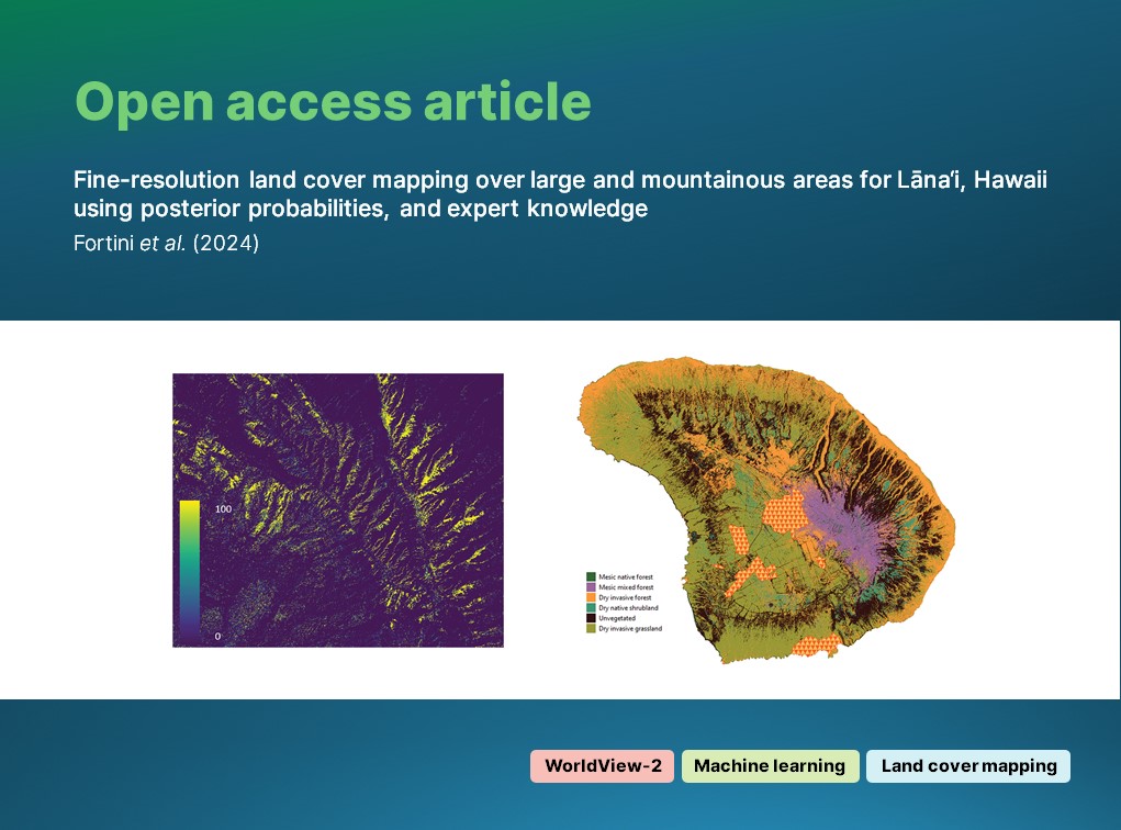
🔓 OPEN ACCESS article:
Fortini (@USGS) et al. leverage #WorldView2 #optical imagery, #MachineLearning and expert knowledge to classify vegetation in topographically-complex Hawai'i at a high accuracy.
🔗 https://t.co/bnQ7Y6CJfX
#IJRS #RemoteSensing #NeuralNetworks #LandCover
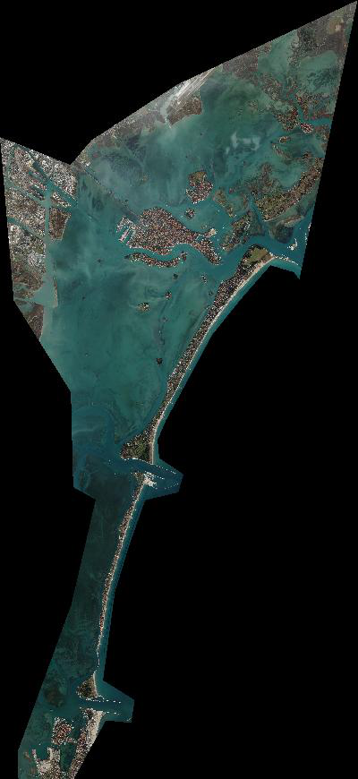
Explore the stunning beauty of #Venice's Lagoon 🇮🇹 captured by @ESA's TPM, @Maxar #WorldView2 in Jan 2019! Dive into the rich ecology of the marsh vegetation and topographic data for retrospective analysis🌍🛰️
Access the data & more: https://t.co/AgtTngMnXc
📷@EUSPACEIMAGING

#OTD 14 years ago a #Deltall #launched the #Worldview2 #Spacecraft from #vafb #vsfb #vandenberg https://t.co/727CMq4dnZ


🔔 New article:
Wang et. al. (@OhioState) estimate #forest #canopy height change using #MachineLearning, #WorldView2 stereo imagery and #Landsat7 data; and compare stereo-image and airborne #LiDAR canopy height models (#CHM).
🔗 https://t.co/CiBYV0j0fk
#IJRS #RemoteSensing

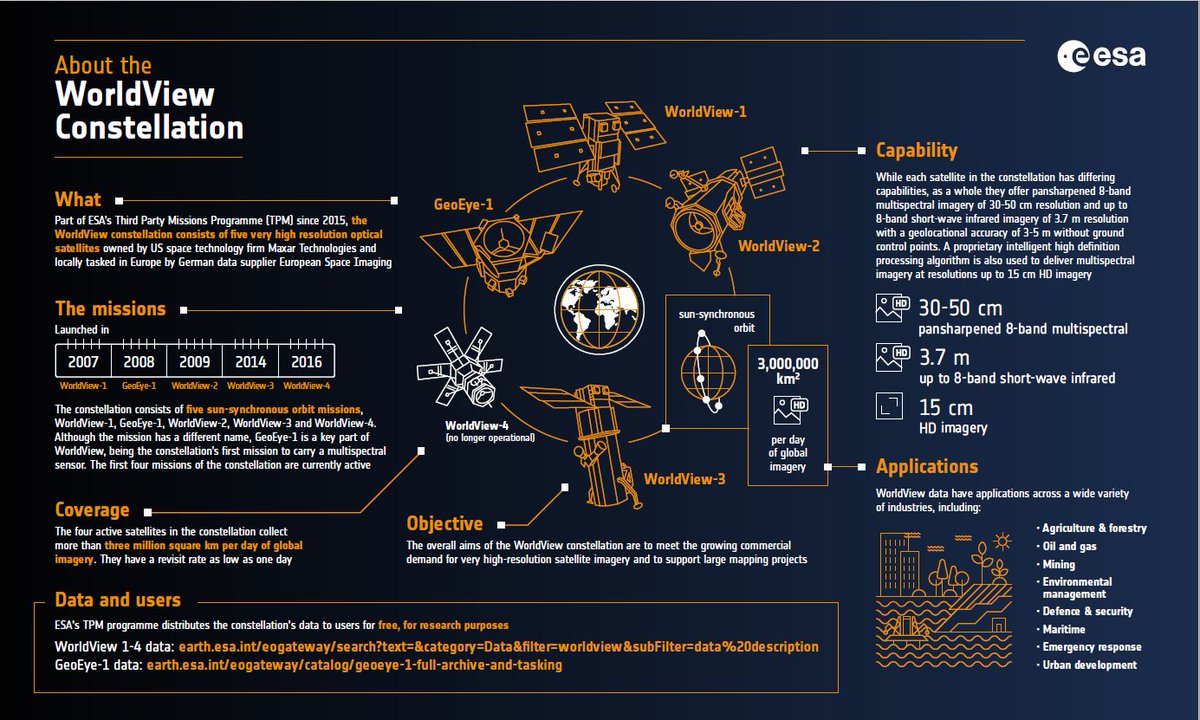
Learn about @Maxar's #WorldView constellation, part of #ESA's #ThirdPartyMissions programme, in our latest infographic.
See: https://t.co/QZupObht8Q
#Worldview1 #Worldview2 #Worldview3 #GeoEye1 #Worldview4 #TPMprogramme @EUSPACEIMAGING

[Paper of the week]
“#DeepLearning detects #InvasivePlant species across complex landscapes using #Worldview2 and #Planetscope satellite imagery”
This paper proposes an approach to detect an invasive plant from North America, the leafy spurge, using two types of #SatelliteImagery

Polygons.
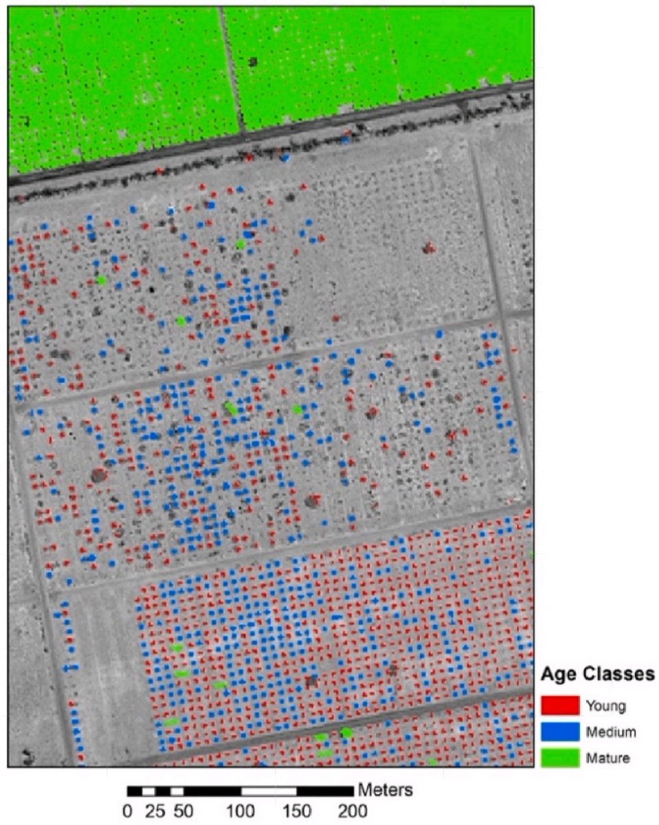
Date #Palm plantations in #UAE at different age stages:
1. Young: < 5 years
2. Medium: 5–10 years
3. Mature: ≥ 10 years
After applying object-based #classification method on sub-meter #WorldView2 imagery, then, #Vectorizing.
#RemoteSensing #GIS #30DayMapChallenge

@EUSPACEIMAGING captured imagery of an extensive #OILSpill more than 20 sq km in the #aegeansea from the sinking of a freighter on Saturday 28 August and current clean up efforts with #WorldView2 and #WorldView3.
#pollution #disaster #maritime


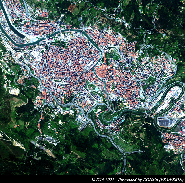
EUSI #Worldview2 Aug 2011 image over #Bilbao, northern #Spain's most prominent city located in #PaísVasco (#Euskadi) autonomous community; #RiverBilbao is seen snaking across the city towards its ocean estuary (~16 km NW) on the Bay of Biscay, which shapes Bilbao's rainy climate.

3/6 ⭐️#SAR_STAR @LDR1's PhD from @CarletonDGES evaluated #wetland 🌾attributes using #RADARSAT2, #Landsat & #WorldView2 imagery, #objectbasedimageanalysis & #timeseries analysis in eastern #Ontario 🇨🇦 as part of a research collaboration w/ @ONresources. #WomeninSAR #WomeninSTEM


#Shoreline Extraction from #WorldView2 #Satellite Data in the Presence of Foam Pixels Using #Multispectral Classification Method
by Audrey Minghelli, Jérôme Spagnoli et al
👉https://t.co/mtsYTa8E6h
#remotesensing #image #water #ocean


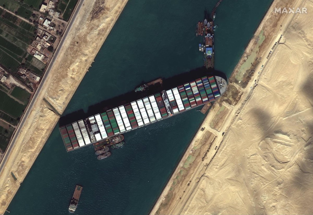
La nave #EverGreen, che ha bloccato il #CanaleDiSuez, in questa foto satellitare realizzata dal satellite #WorldView2 di #Maxar. Ha già creato un ingorgo di 200 navi e le ripercussioni sul commercio mondiale sono preoccupanti: si stima una perdita di 10 miliardi al giorno.

.@jackiehung4 & Treitz (2020) compare parametric and non-parametric algorithms for mapping land cover in #WorldView2 imagery at the Cape Bounty Arctic Watershed Observatory, Nunavut, with highest accuracy from support vector machine. #LoLManuscriptMonday https://t.co/6xJYYas5a0


Campbell et al. assessed change to #saltmarsh #wetlands in #JamaicaBay #NewYork using high resolution #Quickbird2 and #WorldView2 imagery, finding that 21 ha of salt marsh has been lost between 2003-2013 and 3.1 ha lost due to #HurricaneSandy
#rswetlands
https://t.co/sUZwgB4iDs

Araya-López et al. compared the potential of #WorldView2 and #Sentinel2 to map high altitude #Andean #wetlands in #Chile and to estimate soil moisture. Both worked well for mapping, but Sentinel-2 performed best at predicting soil moisture.
#rswetlands
https://t.co/gZ1CaVqOdf


A #RandomForest Modelling Procedure for a Multi-Sensor Assessment of #TreeSpecies Diversity
by Giorgos Mallinis, Irene Chrysafis, et al.
👉https://t.co/CGZaidzNM5
#biodiversityindices
#Sentinel2
#Landsat8
#RapidEye;
#machinelearning
#WorldView2

.@fabiolayepez, @LucreciaRivera & co-authors (2013) fuse terrestrial and airborne #LiDAR data with #WorldView2 and aerial photos to evaluate hydrometeorological impacts on urban structures along the Santa Catarina River in Mexico. #LoLManuscriptMonday https://t.co/nI63EsE24m


Most Popular Users

Elon Musk 
@elonmusk
240.7M followers

Barack Obama
@barackobama
119.2M followers

Donald J. Trump
@realdonaldtrump
111.7M followers

Cristiano Ronaldo
@cristiano
110.8M followers

Narendra Modi
@narendramodi
107M followers

Rihanna
@rihanna
97.7M followers

NASA
@nasa
92.2M followers

Justin Bieber
@justinbieber
90.9M followers

KATY PERRY
@katyperry
87.8M followers

Taylor Swift
@taylorswift13
81.6M followers

Lady Gaga
@ladygaga
73.2M followers

Virat Kohli
@imvkohli
70.1M followers

Kim Kardashian
@kimkardashian
69.8M followers

YouTube
@youtube
68.7M followers

Bill Gates
@billgates
64M followers

Neymar Jr
@neymarjr
62.8M followers

The Ellen Show
@theellenshow
62.4M followers

CNN
@cnn
61.9M followers

Selena Gomez
@selenagomez
60.9M followers

X
@x
60.8M followers