Keeping an eye on the tropics as a tropical wave now has a 40% chance of slow development in the next 7 days as the system moves W-WNW across the Caribbean Sea next week. #FLwx Get more info at https://t.co/g9ox0UAaOO
On this date 19 years ago, Hurricane Katrina's huge 30 mile wide eye was sporting 175 mph winds...even though Katrina officially made landfall as a Cat 3 with 125 mph winds on the 29th, this huge storm already had written that it was going to bring a tremendous and record-breaking storm surge.
At it's most intense on the 28th, the pressure was down to 902mb/26.64" and was likely producing peak waves over 100 feet in the Gulf of Mexico...the surge along the Mississippi Coast reached a record 27 feet that penetrated inland some 6-12 miles.
With the levee failures in the New Orleans area the storm became the most costliest on record with 200 billion dollars in damage, and tragically, an estimated 1,836 fatalities.
23 days later a more intense Hurricane Rita (180mph/885mb max) struck the Louisiana Coast as a Cat 3 bringing a huge storm surge that covered more than 1500 square miles of coast and up to 30 miles inland.
Hurricane Wilma a month later (183mph/882mb max) went on to become more intense than both Katrina and Rita.
I'll never forget covering that storm and its aftermath...
Let's hope we never see another season like 2005... #lawx #HurricaneKatrina
The 2nd Disaster Preparedness Sales Tax Holiday starts TOMORROW & goes until Sep. 6!
Residents can update their disaster supply kits with items like generators, pet supplies & more, all tax free!
Visit https://t.co/h4hM2sHCin for a list of eligible items & read more below ⤵️.
☔️ Weak boundary should move across the peninsula today bringing back showers and storms, especially over SW portions of the state!
😎 Then, we get a few days of much drier & pleasant conditions during the weekend! Dewpoints in the upper 60s & lows in the low 70s!
#FLwx
#OTD in 2004, Hurricane Charley made landfall as a Category 4 storm in #SWFL. #DYK, Charley was one of 5 storms that impacted #Florida in just six weeks, making it the costliest hurricane season at the time 🌀
Learn more 👇 #flwx
https://t.co/LRpLw9iYrG
https://t.co/1vEuU6ye0x
Happy Birthday to me! 80 years young, and still spreading wildfire safety fun. Cheers to eight decades of saying #OnlyYou can prevent wildfires!
#SmokeyBear80
The Sandbag site at the Ridge Manor Community Center is open for the remainder of the week and will close Sat., Aug. 10th at noon.
Hernando County will continue to monitor conditions of the Withlacoochee River and will notify the public if the need to reopen the site occurs.
A tropical wave over the central tropical Atlantic has a 50% chance of tropical cyclone formation within the next 7 days as it moves to the west-northwest towards the Lesser Antilles by early next week.
Did you receive damage or have debris? Listen up, we've got some updates!
📌💻🏡 Hurricane Debby Damage Reporting Form ➡️ https://t.co/8isAKO1HAi
#HernandoPrepares
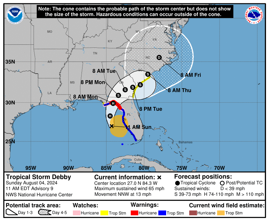
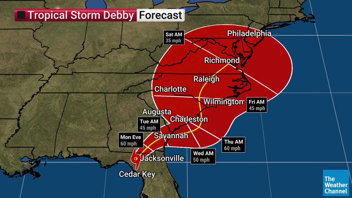
JUST IN: #Debby weakens to a Tropical Storm. Catastrophic flooding remains a major threat across the Southeast as the system stalls near the coast.
Stay tuned to The Weather Channel for the latest updates.
Hurricane #Debby nearing landfall in the Florida Big Bend. Life-threatening storm surge and potentially catastrophic rainfall expected. Here is the 4 am EDT update. https://t.co/tW4KeGdBFb
#Debby will drop A LOT of rain over the next few days.
Potentially historic, heavy rainfall is forecast across southeast Georgia and South Carolina through Friday morning. This may mean areas of catastrophic flooding.
Prepare now for this possibility and follow your local NWS forecast office for more: https://t.co/Uw2lDwqToR
Tropical Storm #Debby continues to impact the area! The threat from flooding rainfall, storm surge, scattered tornadoes & winds continue through Monday!
Remember
✅ Have multiple ways to receive warnings
✅ Stay protected during the storm
✅ Use caution after the storm
#FLwx 🌀
In preparation for Tropical Storm Debby, Commissioner Brian Hawkins, Director of Public Safety, and Fire Chief Paul Hasenmeier visited Bravo Battery 3rd Battalion 265 Air Defense Artillery National Guard from Fort Myers, FL., that was pre-staged in Hernando County.
A grand total of 15,994 sand bags were handed out in preparation for Tropical Storm Debby in Hernando County.
Linda Pederson Park
6,099
Ridge Manor Community Center
2,820 Bags
Anderson Snow Park
7,075 Bags
#HernandoPrepares#HernandoResponds
The Hernando County Public Information call center is now open. They tell me the majority of questions they are receiving relate to the voluntary evacuation order and emergency shelters. You can reach them at: 352-754-4083. @HernandoCo_EM
#RIGHTNOW: Hernando County officials and community partners are gathered at the Hernando Co. Emergency Operations Center. There is a voluntary evacuation order for Zone A, mobile home communities and other low lying areas of the county. @10TampaBay@HernandoCo_EM
Tropical Storm #Debby continues to move north!
💧Flooding rain: 6-12 in w/ isolated higher amounts
🌊Storm Surge: 4-7ft Levy Co, 3-5ft Citrus south through Tampa Bay, 2- 4ft elsewhere
🌬️Tropical Storm force winds possible, except Hurricane force possible in Levy County
#FLwx 🌀