THUNDERSTORM OUTLOOK
VALID: Today
[UPDATE 1] Severe thunderstorms possible. A broad moderate and strong areas has been outlined where any storms that form could quickly turn severe with a risk of flash flooding, large hail, and damaging winds.
https://t.co/AcdjvtQw3T
That time a THE PRICE IS RIGHT contestant (Alene Glover) blacked out after winning the Showcase, so the show just ran the credits while they tried to revive her lol (1976)
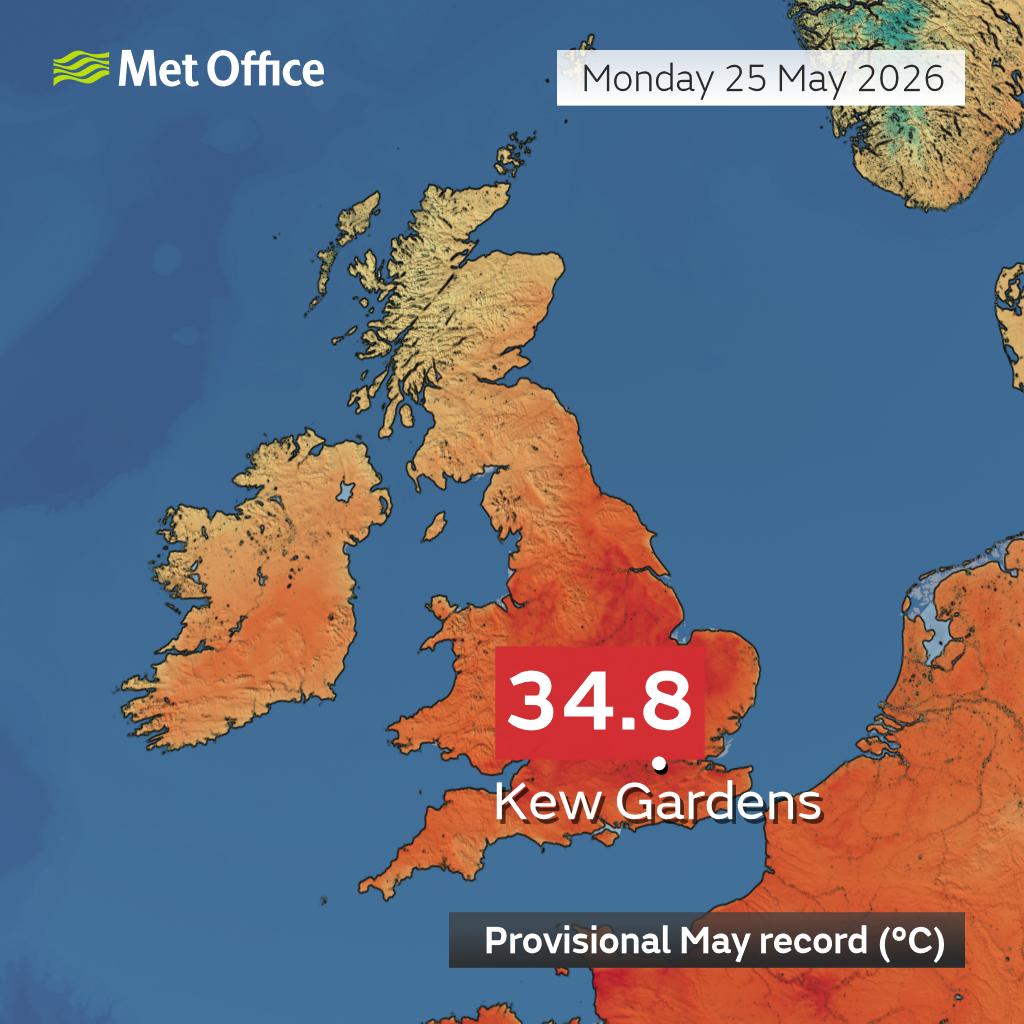
Today has been the hottest day in May on record with Kew Gardens provisionally reaching 34.8°C - exceeding the previous highest May temperature in the UK by a full 2 degrees Celsius🌡️
This heat would be exceptional in the UK even in mid summer, let alone in May📈
Looking at the instability on Tuesday, it’s pretty remarkable.
Parts of the South West, southern England, almost all of Wales, the Midlands, and even some northern areas are showing high to extreme CAPE values between 1000–3000 J/kg on the UKV model. That kind of instability in late May is extremely rare for the UK.
If storms do initiate as some models suggest, they’ll likely be pulse-type thunderstorms due to weak wind shear and limited large-scale forcing. That said, individual pulses could still become locally violent due to the high CAPE values, producing frequent lightning, medium-sized hail, and a risk of flash flooding, especially if they develop along convergence zones and manage to break through the high pressure.
There’s still some uncertainty as not all models are showing clear initiation yet, but the ingredients are very strong: abundant moist air, strong surface heating, cold air aloft, and steep lapse rates. The high CAPE values shown on this chart are definitely not exaggerated.
This new app can be your time machine to revisit past weather.
Weather Replay from @copernicusecmwf enables anyone to revisit the weather anywhere on the globe, hour by hour, from January 1940 up to a few days before present.
Try it out 👉 https://t.co/ieoaI4fVs0


![UKWX_'s tweet photo. THUNDERSTORM OUTLOOK
VALID: Today
[UPDATE 1] Severe thunderstorms possible. A broad moderate and strong areas has been outlined where any storms that form could quickly turn severe with a risk of flash flooding, large hail, and damaging winds.
https://t.co/AcdjvtQw3T](https://pbs.twimg.com/media/HJNGCvLXEAEqICF.jpg)