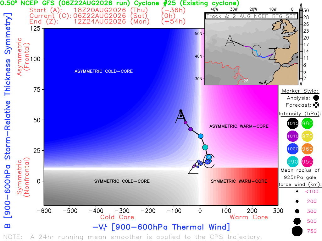
Low-pressure system developing over the central #Mediterranean. The white areas show the curling bands of #clouds. The deep red in the cloud-free areas reveals one of the culprits behind the development: the cold air droplet, shown here as descending, dry stratosph. air
#weather
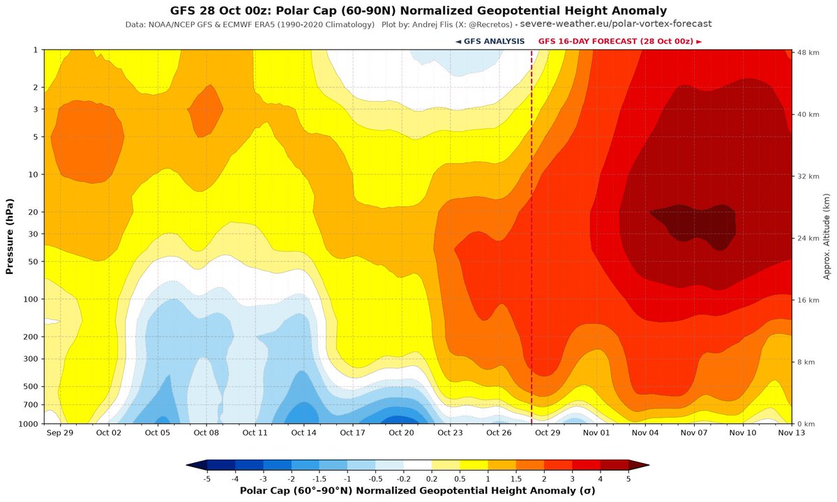
I have a sneaking suspicion that the extreme eastward shift & intensity of this yr’s “Super” El Niño has something to do w/ the unprecedented, exceptionally early Sudden Stratospheric Warming Event that’s in most model forecasts
Plots via @Recretos’s site
https://t.co/OUtrAXYXRe
Dos eventos de precipitación de más de 700 mm en dos años!
Cualquiera en los años 80-90 te diría que algo así es virtualmente imposible. Pero hoy ya no estamos en ese clima, estamos en una nueva realidad climática que te puede producir estos eventos con facilidad, qué barbaridad...
No queda otra que adaptarse. Adaptación y preparación.
Y no solo esto es espectacular, lo que ha ido ocurriendo estas últimas semanas no son para nada propias de un otoño típico del Mediterráneo.
Tras este evento inédito y las extremas temperaturas del mar asociadas, me pregunté junto con @MeteoZGZ por el impacto de estas. Rápidamente nos pusimos a analizar la situación.
Los resultados son muy llamativos y queremos dar un pequeño adelanto, a falta del informe final (ojo: son resultados preliminares) que publicaremos en los próximos días:
El 3 y 4 de octubre de 2026, un gran sistema de tormentas frente a Cataluña dejó lluvias torrenciales (190,8 l/m² en Barcelona) sin la DANA que suele estar detrás de estos temporales, pero con un Mediterráneo unos 2,5 °C más cálido de lo normal. El satélite y el radar mostraron un sistema con aspecto tropical, compatible con un intento de formación de un ciclón de tipo tropical.
Al simular el episodio cambiando solo la temperatura del mar, el sistema de tormentas, su remolino y las lluvias de más de 250 mm aparecen solo con el mar real. Con un mar normal para la época, o entre 2,4 y 2,9 °C más frío, no se forman.
Esto no demuestra que se formara un ciclón tropical (no es el objetivo del análisis de momento), pero encaja con esa idea: el calentamiento del Mediterráneo podría estar abriendo una nueva vía para que se formen ciclones tropicales en la región.
Esta figura es una muestra:
Izquierda: simulación de control con mar con temperaturas reales.
Centro: simulación con mar con temperaturas normales (1991-2020)
Derecha: diferencias.
At the same time, we are experiencing one of the strongest El Niño events on record. However, it is difficult to predict how this will affect the European winter. There is only a slight tendency toward slightly wetter winters and springs during El Niño phases.
#elnino
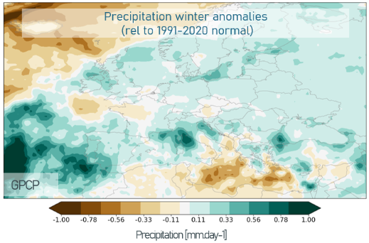
The seasonal forecasts (1st graph) offer some hope for the #drought-stricken regions stretching from Western through Central to Eastern #Europe (2nd graph). Of course, the trend shown here for #winter should be viewed with caution. But this hope is definitely not unfounded.
Devastating glacier loss in Switzerland in the extreme year 2026 - 5.5% of the remaining ice is gone! I'm still struggling to grasp the extent of this decline.
This loss almost catches up with the record-shattering year 2022: too little snow in winter and intense heat
@glamos_ch
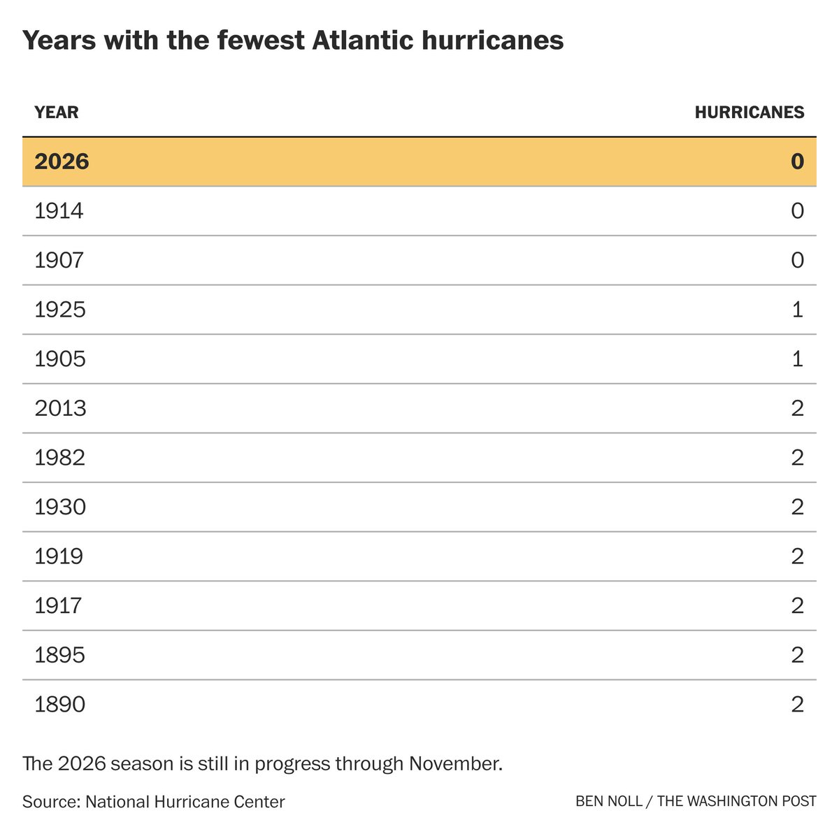
Could 2026 become a year without a hurricane in the Atlantic?
It can't be ruled out!
El Niño is only part of the story. Something else is happening: the tropical atmosphere has been more stable 🧵
The bedrock under a melting glacier fractured after the warmest week of 2026, but some will confidently tell you that it obviously had nothing to do with climate change.
Feels like an anti-vax argument actually. Dying with climate change, not because of climate change?
Sigh.
In a few days, it's going to get really dusty in the western #Mediterranean. It will be interesting to see if the #desert#dust actually makes it all the way to southern #Germany in such high concentrations as suggested by this model run.
#Sahara#Europe#weather#airquality
@Kachelmann@aus_pete Da sie mittlerweile fast alles als "fahrlässige Brandstiftung" bezeichnen, haben sie auch Ideen, woher die Billionen Euro kommen sollen mit denen man auch jedes noch so kleine Risiko für einen Brand vermeidet (technische Ursachen, etc)? Ihre Ansicht ist einfach nur weltfremd!
The IPCC may be underestimating the transient climate response (TCR) by 0.4–0.5 °C. I hope more research on this will be conducted as soon as possible, because it's crucial for policy-making! ♨️
#climatechange#climate#sensitivity
https://t.co/9vAYXS8I8N
@cornelia_ott@NurderK Ich bin kein AKW Verfechter. Mir ist nur aufgefallen, dass das Argument mit den Flüssen keinen Sinn macht. Zumindest das Problem würde sich lösen lassen.
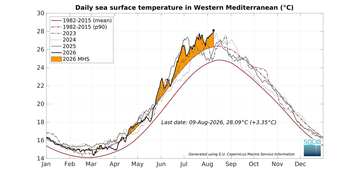
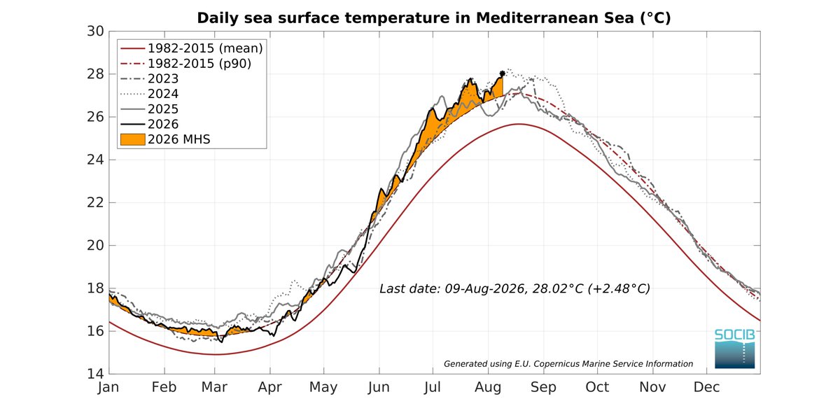
The western #Mediterranean (left chart) is now #record warm, even on spatial average. The Mediterranean as a whole (right chart) will probably reach a new extreme value in the coming days.
https://t.co/3IQ1hHhTHf
#marine#heatwave#Europe