We're still watching the possibility for strong to severe storms late Monday and into early Tuesday (April 27-28, 2026.
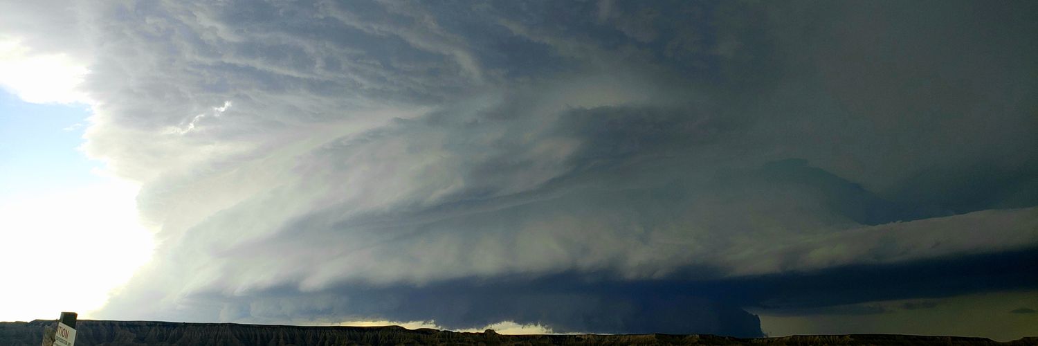
Strong storm system moving from the southern plains up into the midwest will likely spark off quite a bit of severe weather out to our west. This includes parts of eastern Missouri, central and southern Illinois, and potentially even far west Kentucky. That's where the greatest threat for widespread severe weather will be, likely including the potential for strong tornadoes, very large hail, and damaging winds.
The storms move closer to the WABBLES region after the sun sets and we start to see the storms outrun not just the better wind energy, but the better storm fuel as well. By this point, it's likely that storms will have congealed from individual supercells to more of a linear structure. This lowers (but doesn't eliminate) the tornado threat, with damaging winds in excess of 60mph becoming the primary threat. Some large hail and isolated tornadoes will also be possible within the line.
Forecasts will continue to be fine-tuned as we get closer to Monday and that's when we'll be able to get more specific with timing than "late Monday evening into early Tuesday morning."
Check back frequently for updates as we get closer!
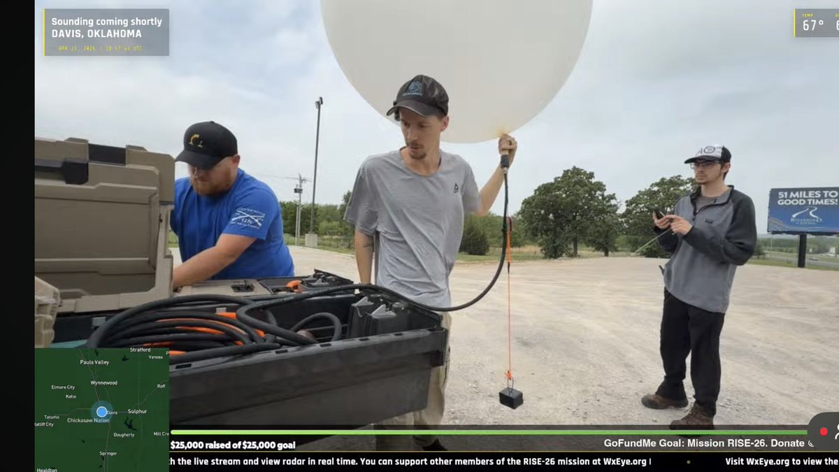
Sounding in progress from Davis, Oklahoma. Track here: https://t.co/QZPDbpEQCM
We will have the full sounding with parameters as soon as balloon bursts.
@stsweathereye@RadarOmega@NWSNorman
We had the incredible opportunity of having ATL legend Glenn Burns as a guest on Episode 8 of our podcast! Great stories and insight from 42 years as chief meteorologist with WSB-TV. Check it out!
https://t.co/xFWhK5xgE9
@cyclonePORT network showing the substantial gradient in snowfall accumulations within a short distance inside the ATL metro area this am.. Canton GA has little to no accumulation while areas 30 miles east are picking up on heavier snowfall rates. #gawx
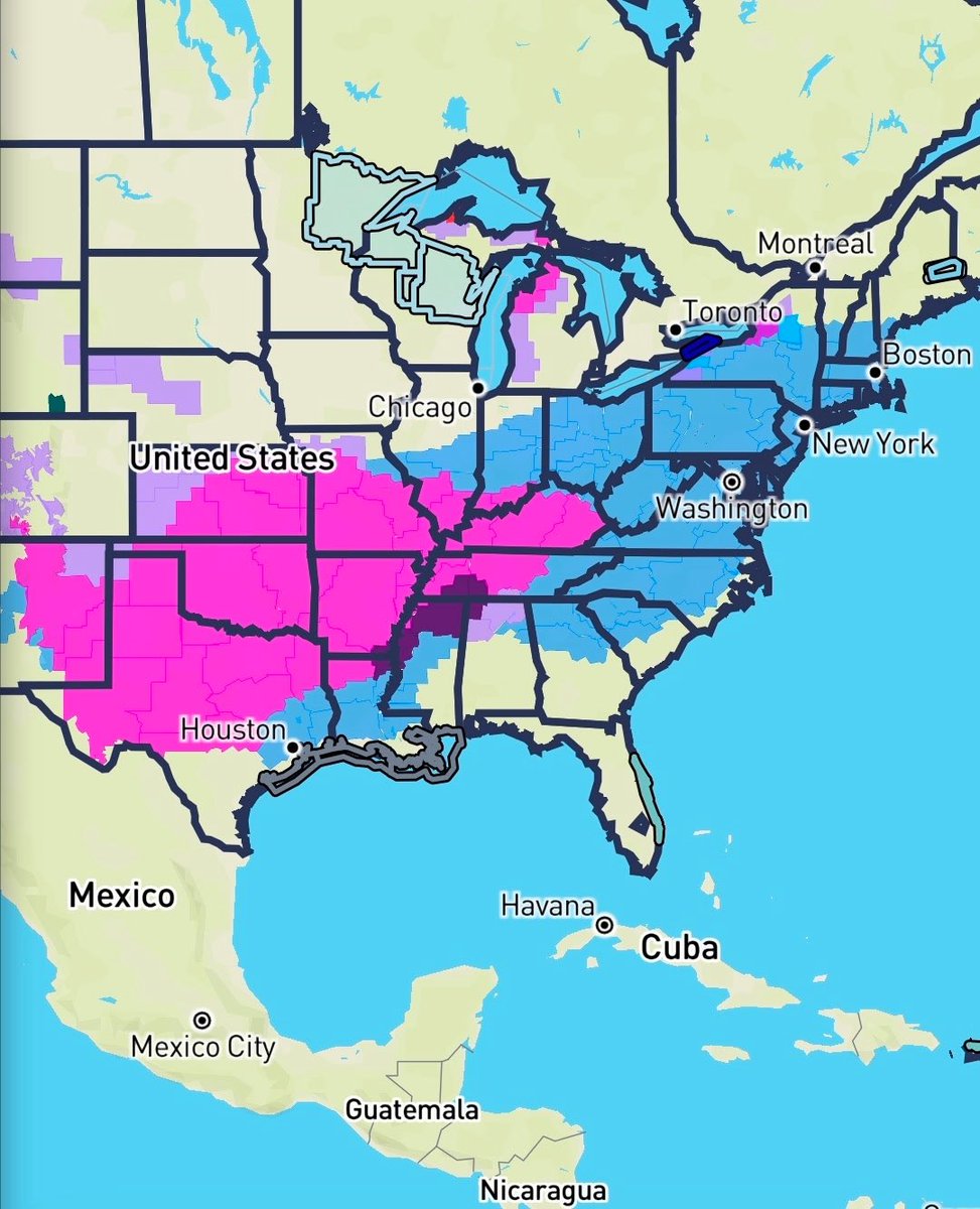
En route to go track this potentially HISTORIC winter storm. We are planning on streaming Saturday, Sunday, and Monday. Snow totals could be measured in multiple feet in areas that haven’t seen this magnitude of snow in years. There is going to be impacts further south with heavy amounts of mixed winter precip, with some areas seeing multiple inches of sleet. Beyond the sleet, a crippling ice storm could impact millions from Dallas Tx to northern Mississippi over through the western Carolinas and into the far southern mid Atlantic states. Ice accretions could exceed 1 inch in multiple areas. If you haven’t yet, you need to prepare NOW for impossible travel conditions, electrical outages for days (or weeks depending on amounts of ice). This means making sure that you have enough food, water, food for your animals, devices charged, medications, and a warm place to stay for an extended period of time. Get those blankets and flashlights ready!
You can follow us live on YouTube or on the Radar Omega app, where you can download below for iOS and Android
https://t.co/vCcgPPH0aO
https://t.co/IxpmHDBBeU
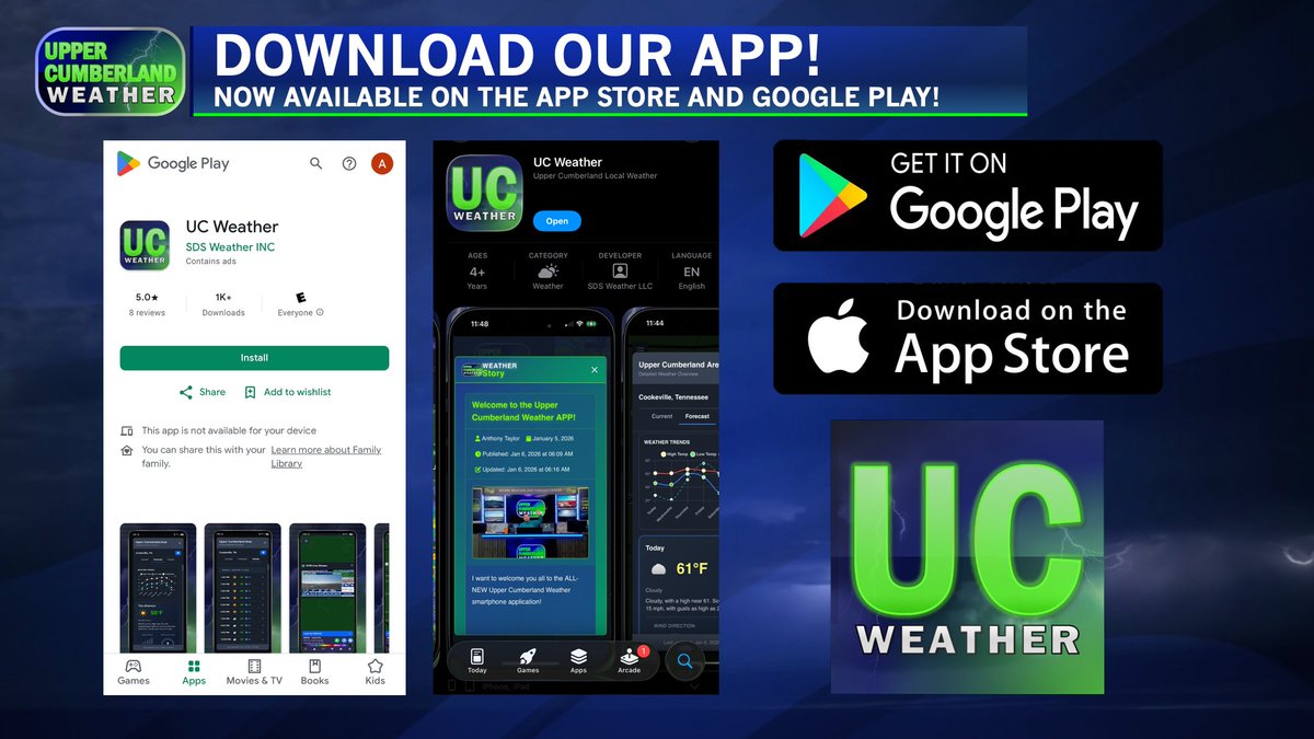
SURPRISE!!! The Upper Cumberland Weather app is now available for download for iPhones!!! Search ‘UC Weather’ on the App Store, or go here: https://t.co/GIckTjCo63
We’ve now surpassed 1,000 downloads on Android devices and are trending at # 34 on the Google Play Store! Here’s where you can download for Android: https://t.co/5P8vr4TcGi
*note: we are aware of a glitch impacted a very small number of Android users that isn’t allowing access to the app - our developer is investigating the issue.
Here’s our full app release announcement from the other day, in case you missed it:
AT LAUNCH TODAY, here are a few key highlights of what our app is giving you:
- SITE-SELECTABLE DOPPLER RADAR WITH DIFFERENT PRODUCTS AND ON-SCREEN WEATHER ALERTS
**This may be an industry first for a LOCAL weather application. Most local weather apps only give you a national composite image that could be as much as 10-20 minutes old and becomes very 'blob-like' the further you zoom in. A handful of local apps will let you see base reflectivity from the nearest NWS radar site, but these are few and far between. Our app? We're giving you access to the ENTIRE network of NWS NEXRAD radar sites throughout the contiguous 48 states, including all four of the radar sites surrounding us (Old Hickory, Hopkinsville, Hytop and Morristown). And it's not just base reflectivity! We're offering more advanced products like velocity and rainfall estimates, among others! These products update in real-time as new scans are made by radar, ensuring what you are seeing is as up-to-the-second as possible. If you want to see a national composite image to get the 'full picture,' we offer that too! And our version of it is MUCH better than most other apps!
**as for weather alerts, these are fully customizable to display whichever watch, warning and advisory products you want to see directly from the National Weather Service directly on the radar map. SPC Outlooks and mesoscale discussions can be toggled on/off, as well!
- OUR SKYCAM NETWORK WITH LIVE VIDEO FEEDS
**Our entire network of more than three dozen SkyCams here in the Upper Cumberland is available to you on demand! These are LIVE high definition video feeds capturing nearly every corner of the Upper Cumberland! You can also view the entire network of cyclonePORT camera sites throughout the country directly within our app, as well! Simply select the 'Weather Stations' toggle at the bottom of the screen.
- CURRENT CONDITIONS AND FORECASTS
**This wasn't yet ready when I originally showed off the app, but it is here at launch! Select up to 10 cities to view weather information for, including current conditions, seven day forecast and an HOURLY forecast. Here's the best part: these are NOT algorithmic products like most weather 'crap apps' give you. Current conditions are derived from the nearest airport as soon as new data is available (a future revision of the app will display live weather data directly from our SkyCam Network). Forecasts for both the seven-day and hourly products are derived straight from the National Weather Service. These are REAL forecast grids created by actual meteorologists serving our area, not a 'guesstimated' forecast that updates every five minutes based on whichever model just farted in the wind.
- WEATHER STORIES
**I'm super excited for this addition! This is my personal zone where I can post daily forecasts written by yours truly, complete with graphics and even video! We'll be further developing this section as we go along, but it's already pretty slick at launch with our first discussion post already made!
- THE UPPER CUMBERLAND WEATHER CHANNEL
**We're on YouTube, we're on HUB Plus (Roku), and now our channel is available directly within our smartphone app for viewing! For some of you, this may be the first time you've ever been exposed to our channel! Not only can you watch our channel 24/7 within the app, but you'll be able to watch our severe weather coverage here, as well!
I want to give a HUGE shout out to our partner, SDS Weather, for developing this app. I especially want to thank @meteodon for the hard work and countless hours that have gone into creating this app quite literally from scratch.
The launch of our app today is the dawning of a new era. We're setting out to redefine what a local weather app SHOULD be, and what we've released today is only the beginning... MANY MORE FEATURES are planned for the near and extended future!
Push notifications are already in the works -- I'll be able to send a notification directly to your phone anytime I'm going live with severe weather coverage...or if there is any other important information I need to share with you. This feature will be included in one of our first updates very soon, among others that will come down the line!
I greatly appreciate the patience of each and every one of you as we've worked to get the app out to you. Our great communities deserve the very best when it comes to hyperlocal, real-time weather information you can trust, and I'll never stop working toward improving upon that mission.
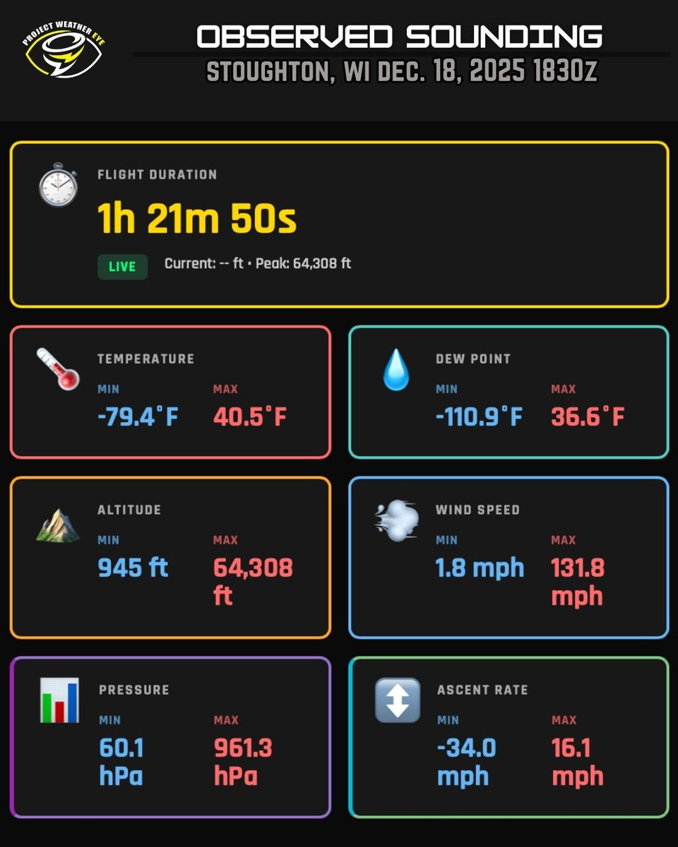
Min/Max stats of our weather balloon sounding today at 1830z. Summary: It's cold and very windy up there at 65,000 feet. Check out the max wind speed of 132mph!
Entries for our 9th Annual Christmas Giveaway are now OPEN!!! This is Facebook only, open to those who live in the Upper Cumberland region of Middle/East Tennessee. Head over to our Facebook page to enter!
PWE has been hard at work. The entire team from me to our developers, hardware engineers and chasers. That includes our partners, supporters, and even the audience for keeping up with it all.
We have the intent to blend weather data collection, research, and live content thru a collaborative effort between our staff, partners, and viewers.
These crowd-funded science missions are highly funded by the audience. We’re running a fundraiser to reinforce the budget a bit and ensure we don’t have to skimp in 2026. We’ve reached 20% of our goal in 3 weeks! https://t.co/50RZtbBfIM