@Reuters This hurricane will be like hurricane Maria 2017 cat 5 in Puerto Rico. The island was devastated, with no electricity by a year, thousands died, and the aftermath with a total collapse of services. The telecommunications was destroyed. This will happen again with Jamaica.
@zurdodederechas El dinero de la cr^2 r0j@ nunca llega a la gente. Eso pasó en Puerto Rico después del Huracán María y hasta en Haití después del terremoto. Nunca llegaron las ayudas a la gente. Son unos mafiosos.
Lo que hemos presenciado hoy con la reentrada a atmósfera y captura del Raptor Booster de @SpaceX no solo roza lo imposible, es que roza lo que alguna vez creíamos que solamente sería ciencia ficción. El vídeo de la reentrada completa te vuela la cabeza.
It’s time to shelter-in-place from #Milton. Tropical-storm force winds, flooding rains, and tornadoes are spreading inland across FL. Unless a life-threatening situation arises, stay indoors and follow updates.
#MILTON is expected to grow in size and remain an extremely dangerous hurricane when it approaches the west coast of Florida on Wednesday. A large area of destructive storm surge will occur along parts of the west coast of Florida on Wednesday.
This is an extremely life-threatening situation and residents in those areas should follow advice given by local officials and evacuate immediately if told to do so.
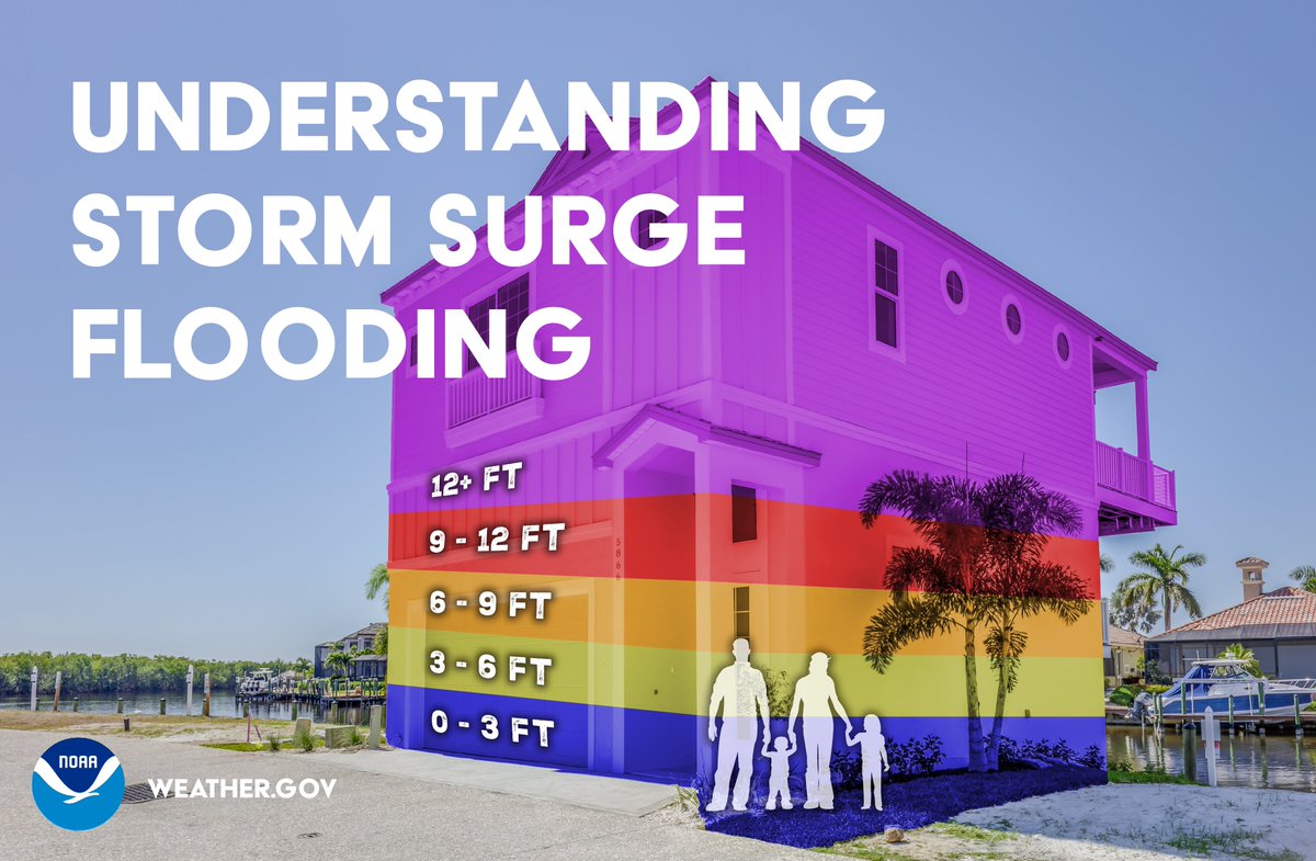
🌊 NOAA NWS National Hurricane Center storm surge forecasts are given in feet above ground level.
🌊Adding to the destructive power of surge, battering waves may increase damage to buildings directly along the coast.
Radar view vs. window view of Hurricane #Milton!
The @NOAA WP-3D Orions are equipped with nose radar, Multi-Mode radar on the belly, and tail Doppler radar. Together, they help us safely navigate through the storm while completing mission objectives. #FlyNOAA
8:00 pm | lunes, 7 octubre 2024 | La presión del huracán #Milton ha disminuido a 897 mb, que lo coloca como el 5to huracán más intenso basado en presión en record del Atlántico. Tiene vientos sostenidos de 180 mph y ráfagas sobre 200 mph. Es también la 2da presión más baja registrada en la cuenca del Atlántico desde el 2005.
RESUMEN DE 700 PM CDT...0000 UTC...INFORMACIÓN
----------------------------------------------
UBICACIÓN...21.9N 90.4W
ALREDEDOR 60 MI...100 KM NO DE PROGRESO MÉXICO
ALREDEDOR 650 MI...1045 KM SW DE TAMPA FLORIDA
VIENTOS MÁXIMOS SOSTENIDOS...180 MPH...285 KM/H
MOVIMIENTO ACTUAL...E O 90 GRADOS A 10 MPH...17 KM/H
PRESIÓN CENTRAL MÍNIMA...897 MB...26.49 PULGADAS
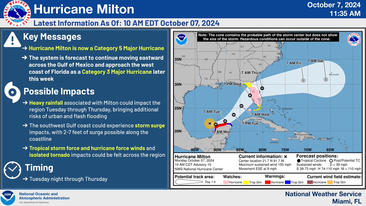
🚨 10/7 11AM Update: Hurricane #Milton is now a Category 5 Major Hurricane , with winds up to 140 kts/160 mph from latest recon data🚨
#Milton will continue moving across the Gulf of Mexico and approach as a Category 3 Major Hurricane later this week. (1/4)
Confidence grew Sunday in the #Mitlon track forecast, which climbed from low to moderate, trending higher. It's hard to find global, specialized, or ensemble model track with landfall outside of the Cedar Key to Ft. Myers stretch of Florida's west coast. (GIF via @burgwx) 1/
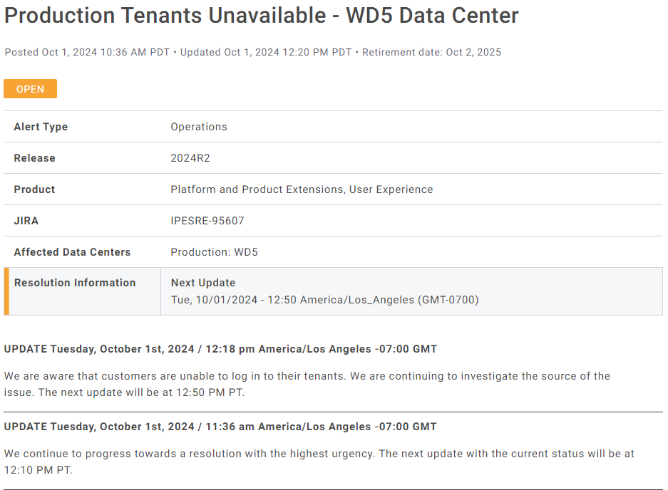
From @workday : Production Tenants Unavailable - Oct 1, 2024 Please be advised that we are currently experiencing an unplanned service interruption to Workday Production tenants in our WD5 Data Center. #workdaydown#workdayoutage