candi-sailor2-8b
Model ini eksperimental aja. Saya fine-tune pake dataset chat 1K candi pake metode LoRA.
LoRA-nya juga tersedia di HF: candi-sailor2-8b-lora.
Use case paling ok kalau mau pake model ini adalah chatbot pengenalan candi-candi di jawa tapi harus digabung sama RAG supaya hasil-nya lebih ok.
Ini target-nya lokal deployment. Cost hanya di hardware dan listrik.
Dari Dataset Statis ke Chatbot yang Nyambung
Dataset candi ini adalah fakta atau data statik: nama candi, lokasi, koordinat, alamat, ketinggian, dan deskripsi.
Tapi cara user bertanya itu dinamis.
Ada yang tanya:
“candi di Sleman apa aja?”
“yang dekat Prambanan mana?”
“koordinat Candi Lor berapa?”
“sejarah Candi Tikus?”
Lalu, gimana caranya supaya dataset statis tersebut berguna untuk chatbot?
Kalau chatbot hanya dilatih dari data statik, jawabannya bisa kaku. Maka akan lebih baik:
Pake user-generated chat data yg membantu "mengubah" dataset statis menjadi pengalaman tanya-jawab yang natural, sesuai cara manusia benar-benar mencari informasi.
AI dipakai untuk mensimulasikan cara manusia bertanya berdasarkan dataset tersebut dan hasilnya ini adalah yg disebut dengan user-generated chat data.
Lalu data-data ini nanti dipakai buat fine-tuning model + RAG.
Kayake minggu ini banyak nyusun dataset 😂
Lagi nyusun data candi-candi di pulau Jawa. Ada data lokasi, deskripsi, dan reverse geo.
Data dikit 100-an. Aslinya dulu pengen punya cuman asli memakan waktu banyak, jd males bgt. Kalau skrg ada AI gas-gas aja, yg penting fact-checking ok. hehe
@LambeSahamjja Ada J-drama yang menceritakan ttg proses jadi pilot cuma lupa judulnya. Ada bagian di mana calon pilot ditempatkan di field crew, baru ganti ke simulator, dan terakhir pendidikan lapangan dengan pesawat asli.
See the world as it is today and in the past! 🌎
Any area on Earth
As recent as the same day
Filters that uncover hidden detail
Free for anyone to use and explore
Satellite Imagery is now in all our hands: https://t.co/xs33gHXxdq 👈
Okay team. Here it is. A 28 m resolution global map of the planet Mars, viewable on Google Earth. The starter version with just 271,790,899,200 pixels. One of the most beautiful things I have ever made. Please, enjoy!
https://t.co/pIdpFqSZNa
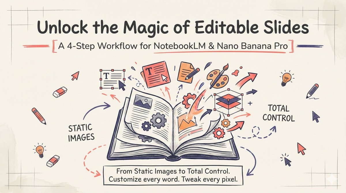
I finally solved the biggest issue with NotebookLM Slides. 🚫✍️
We all love the aesthetic of NotebookLM's auto-generated Slide Decks, but there's a catch: they are static images. You can't edit the text, and you can't tweak the content.
Want that specific style but with full control over every word?
I built a workflow + prompt template that lets you customize everything. Here is how it works. 👇
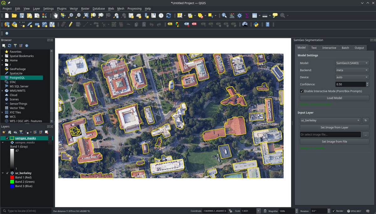
Sneak peek of the SamGeo QGIS plugin! It is going to be epic 🚀
Stay tuned for more demos and tutorials!
GitHub: https://t.co/KUOhmJyArU
#qgis#samgeo#SAM3#opensource#geospatail
Finally, Point Cloud Essentials is a free beta for Blender 5.0 🎉
Crop, screen-select and split dense point clouds directly in the 3D Viewport.
Early beta – expect bugs. Please keep backups.
Download:
https://t.co/A8bOhx5O0c
#b3d#blender#pointcloud
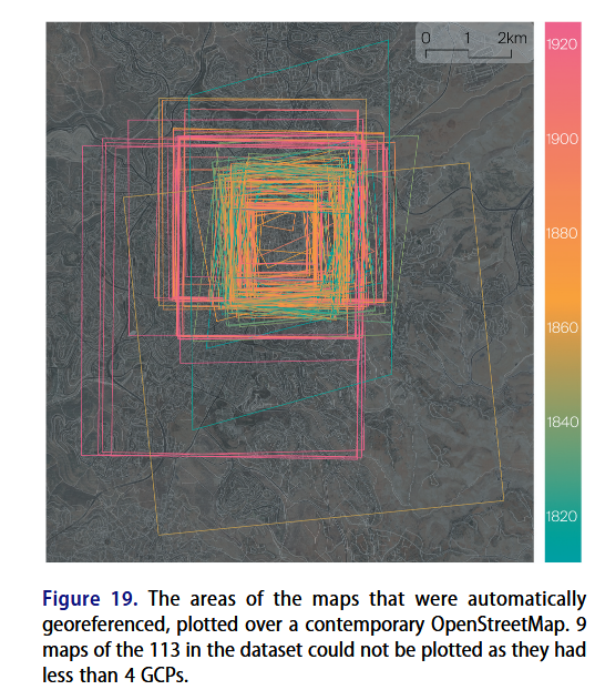
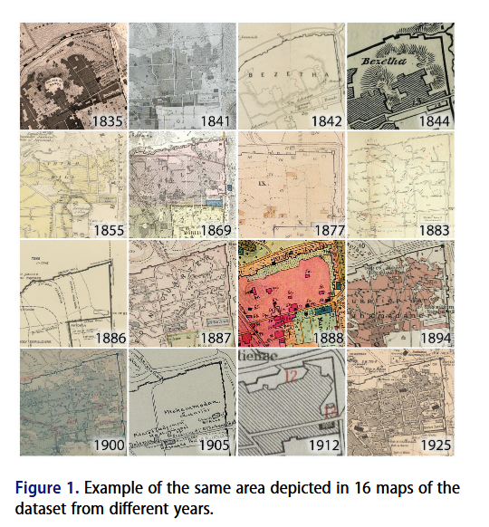
Fantastic article on Georeferencing historical maps using automated processes, including local feature matching and Delaunay consistency from Beatrice Vaienti, Isabella di Lenardo and Frédéric Kaplan https://t.co/VmUd2W1hER #GISchat#OpenAccess
🛰️ Excited to share Skyfall-GS - the FIRST method to create real-time navigable 3D cities from satellite imagery alone!
We transform multi-view satellite images into immersive 3D scenes you can freely fly through! 🚁✨
🌐 Project Page: https://t.co/QsLVaD7mAg
1/5
Link to app. Its a static site so all data runs local in your browser:
https://t.co/QY0MtLkooA
Repo (MIT licence - Do as you please with it 🙂):
https://t.co/GLMYJDK4p2