No tricks. Just treats... and a very festive point cloud. 🎃🚂 👻
LiDAR technology uses millions of data points to help create highly detailed 3D maps of the NS network, giving our railroaders a clearer view of the network so we can plan better, work smarter and operate more safely. Seen here is Riverton Junction in Virginia.
From all of us on Team NS, have a safe and fun Halloween!
Learn more about how our railroaders use LiDAR: https://t.co/U8Jva9O5nP
Newark - every train, light rail and bus NJ Transit and PATH run between 07:30 and 08:00, 30 minutes of timetable.
3 operator feeds merged, on 2 different service dates, 2 of them sharing one and the rest publishing calendars that do not reach it. So this is a composite weekday: each operator's own typical morning drawn together, which names no single date.
1,187 vehicles are moving at once at the busiest instant inside this frame, drawn from 1,843 scheduled runs over 731 distinct paths. Those counts describe this view. The whole feed is larger.
The colours are what NJ Transit and the Port Authority publish as three separate feeds, strongest service first: hot pink for PATH trains, green for commuter trains, red for light rail, muted blue for bus.
The Manhattan edge shows only what crosses the Hudson - the MTA's subway and buses are left out of these feeds.
Positions are interpolated between scheduled stop times. It shows the timetable. It does not show GPS or live traffic.
Data: NJ Transit and Port Authority Trans-Hudson (PATH) GTFS, each published under its own operator's terms.
𝐓𝐡𝐞 𝐍𝐞𝐰 𝐒𝐜𝐢𝐞𝐧𝐜𝐞 𝐨𝐟 𝐌𝐚𝐩𝐬
#transit #datavisualization #maps #gtfs #urbanism
ICYMI - I released a new desktop browser app that analyzes real-time GPS data from a bunch of transit agencies.
Use it to find where intervention is needed to speed up the bus, and to reduce bus bunching
https://t.co/Aa8wqsevDe
#30DayMapChallenge Day 4 — Clusters 🚲
Where can you find a place to park your bike?
RackFinder turns crowdsourced OpenStreetMap (OSM) data into an interactive map of bicycle racks, built with Mapbox.
By clustering nearby bike racks, the app makes it easier to explore available parking locations without overwhelming the map with individual points. As users zoom in, clusters reveal more detailed locations.
Even better, users can contribute missing bike racks directly to OSM, helping improve the map for everyone.
Explore the map and see how developers can turn crowdsourced location data into useful, community-powered experiences: https://t.co/JKPmH5GS2h
#BuiltWithMapbox #30DayMapChallenge #OpenStreetMap #MapboxGLJS
The new Metro Pulse app launches TOMORROW morning, with exciting new features and improvements designed to make your experience easier and more convenient than ever! 📲
☑️ Get alerts about service disruptions
☑️ Choose light or dark mode
☑️ Report a lost item
☑️ Share feedback about your trip
☑️ View accessibility and parking information at a glance
☑️ Enjoy a polished, improved design
☑️ Improved data accuracy, quality, and app performance
And more! ⤵️
Already have the app? Be sure to update it. Learn more at https://t.co/Ww2gcYSLHf
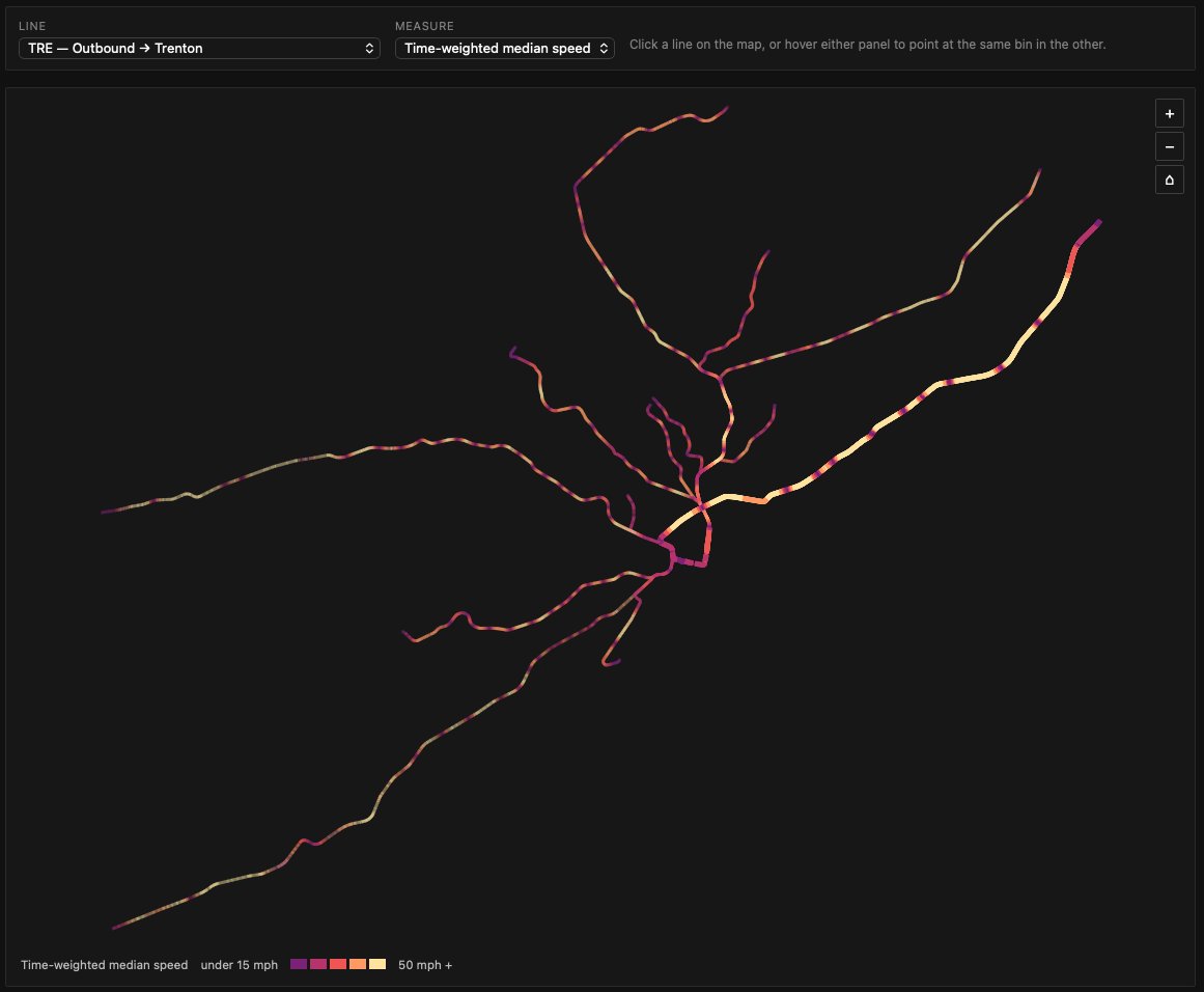
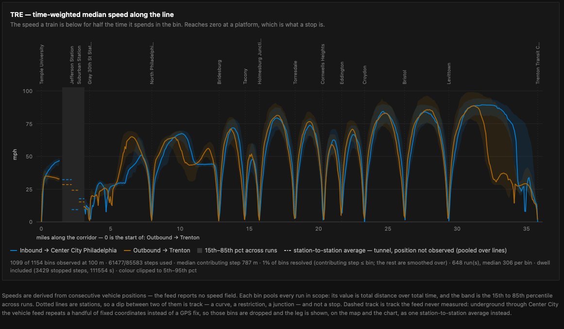
Trying out collecting SEPTA's gtfs-rt feed to do some TransitMatters inspired dashboards.
Here's an interactive site to look at average regional rail route speed profiles.
https://t.co/9bJXAbvsVv
🌟 Get true reachability calculations with the Isochrones API.
This API calculates the area you can reach from an origin point within a set amount of time — but unlike a radius, it accounts for actual road network travel times ➡️ https://t.co/q01DZA6T0X