For the meteorologists:
I finally watched Pressure last night and it was incredible. I caught (what I think is) a subtle yet powerful homage. When Eisenhower shakes a seemingly random soldier’s hand, it just so happens that his name is Euler. I highly doubt it’s coincidental. In my mind this was a nod to the Eulerian principle which is the idea that properties are measured at a fixed location and change over time. In this case, the fixed location was Normandy and communicating how quickly conditions would change is symbology but curious on others’ thoughts.
Hopefully this was a break from your doomscrolling and thanks for your attention to this matter.
On August 20 every year, Dr. Bill Gray would ring a bell denoting the start of the climatologically most active portion of the Atlantic #hurricane season. Historically, about 2/3 of all Atlantic hurricane activity occurs between August 20 - October 10.
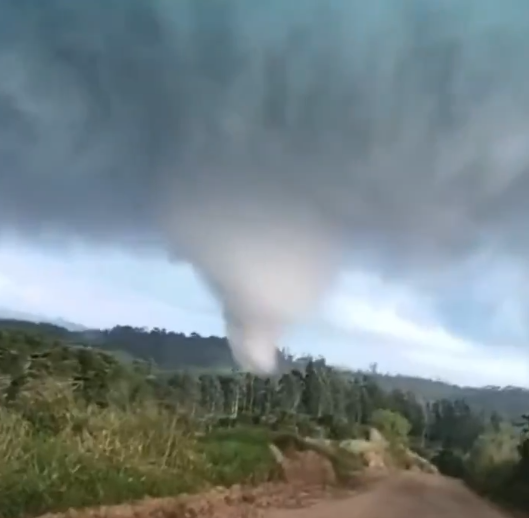
– Atualização da Avaliação de Danos –
O tornado violento que atingiu Piraí do Sul, Paraná, Brasil, em 8 de agosto, foi classificado como um tornado F4, com ventos estimados em pelo menos 380 km/h (236 mph), segundo o PREVOTS (Brasil). O tornado percorreu uma trajetória de 26,1 km (16,2 milhas) e atingiu uma largura máxima de 750 m (820 jardas).
A classificação F4 baseou-se principalmente nos danos extremos à vegetação e ao solo ao longo de partes da trajetória. Isso incluiu a remoção completa de galhos e folhagem de árvores nativas de tronco rígido, o descascamento de mais de 60% dos troncos e um padrão característico de abrasão (efeito de lixamento) em suas superf��cies. O tornado também arrancou grandes áreas de pastagem a profundidades de 10 a 30 cm, com áreas individuais medindo aproximadamente 127 a 188 m². Determinou-se que esses indicadores de danos excepcionalmente intensos eram compatíveis com ventos de pelo menos 380 km/h (236 mph).
Este é o segundo tornado violento (F/EF4+) de 2026, excluindo-se o tornado de Kushva, na Rússia, ocorrido em 22 de junho — classificado como IF3 pelo ESWD, embora um avaliador local lhe tenha atribuído a classificação F4.
A reminder at how effective natural features such as reefs or mangroves are at dissipating wave energy. This is an incredible example of that — look how still the water is landward of the reef.
LIVE update from beautiful Ishigaki, Japan in the path of Super Typhoon #Bavi with massive breakers out at the reef. We are in preparation and scouting mode today on this stunning island. The conditions will begin to deteriorate tomorrow night
#stormchasing#Dominator
I think this is an absolutely fair critique of “general” forecasts. On the meteorology, the evolution synoptically is highly favorable to air-mass recovery given the south-southwest trajectories behind the morning convection. It’s uniquely positioned to advect low-level moisture behind the convection, ahead of the cold front, on highly anomalous low-level flow for June. South-south-easterly flow could not achieve this but this synoptic can which is why I think the ceiling is high.
Likely violent #tornado (EF3+) destroyed multiple homes, twisted high tension power lines, and left significant ground scaring north of Kouts, Indiana.
@MyRadarWX#inwx
The southernmost supercell has an opportunity to produce a strong to violent tornado given the near-storm environment coupled with the impinging bow echo. The pressure perturbation associated with the bow should further enhance backing winds and associated 0-1km srh ahead of the bow which would be constructive for tornadogenesis/maintenance within an already incredibly supportive environment.
Yhis is an interactive to observe closely.
A testament to the storm environment and instability — this supercell, as viewed from the radar near Kansas City, MO, almost 200 miles away, is displaying “Flying V” structure at incredible distance. This storm is 70k feet tall, or >13 miles high in the atmosphere. This is uncommon and is likely able to be observed from a LONG ways away.
I don’t tweet often anymore but this is one worth bookmarking. I’m going to assume ahead of time that this one will be well documented by both chasers and the general public.
I would not at all be surprised if a localized but extreme flash flooding risk developed somewhere around or west of the Kansas City metro this afternoon/evening on the edge of the cap further southwest. Intense, convective rain rates with backward-propagating supercells could produce net zero storm motions. Wherever this sets up could receive jackpot precip totals with rain rates of 3-4” per hour.
13 years since the Moore tornado of 2013. I’ll never forget watching the terminal Doppler data in real-time as it captured incredible detail of this EF-5 tornado.