605 PM - Cluster of thunderstorms moving east out of the Texas panhandle will move into Oklahoma through 9 PM. These supercells produced tornadoes earlier, yet are congealing into a wind threat. #okwx
6/25/26 TORNADOES in the OKLAHOMA panhandle west of Slapout. 5 touchdowns so far. Val Castor and Kyle Wilson News 9 have been tracking them. #okwx#tornado#severe#weather
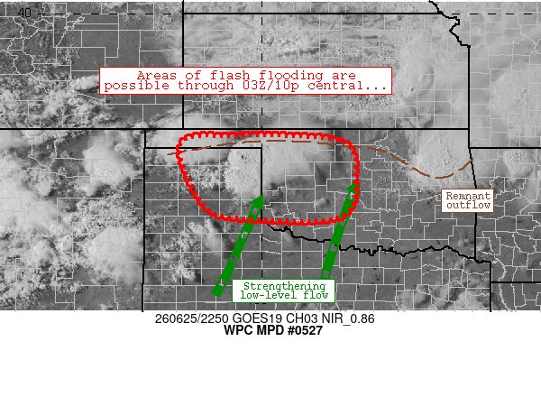
[6/25] 7:30 AM- Scattered showers/storms continue to develop and move across portions of northern and central OK this morning. Heavy rain/flooding is the main concern. Small hail possible with the stronger storms. #okwx
The risk of severe weather is low with storms this morning. However, the risk will increase this afternoon into the overnight with the redevelopment of thunderstorms. Large hail, damaging wind gusts, heavy rainfall/flooding and tornadoes are all potential hazards. #okwx#texomawx
Updated severe weather outlook for Thursday. While there will be some thunderstorms overnight and early Thursday, the prime time for severe storms tomorrow will be during the late afternoon and early evening hours. #okwx#texomawx
An airline passenger captured towering smoke plumes from wildfires burning near Salt Lake County, Utah. Officials say the blaze is not currently threatening any homes or structures.
An impressive look at a supercell west of Amarillo this afternoon. This reflectivity loop from the KAMA radar tower shows the storm organizing across the Texas Panhandle.
You’re ready to play sports, but are you #WeatherReady? Be prepared for, and know how to react to, weather hazards such as heat, air quality, and lightning. https://t.co/VyWINDk3xP