Excited to launch @bridge_rpf!
BRIDGE emerged from a clear but pressing realization: complex global challenges cannot be addressed through disciplinary silos. Philosophy, public policy, and emerging technologies must engage in meaningful dialogue—not operate in isolation.
Excited to launch BRIDGE – Research & Policy Foundation — a nonprofit reimagining how science, technology, and philosophy can work together to shape just and intelligent futures.
https://t.co/v6hznCnRMz
#ResearchWithPurpose#AI#Governance#ClimateJustice#PublicPolicy
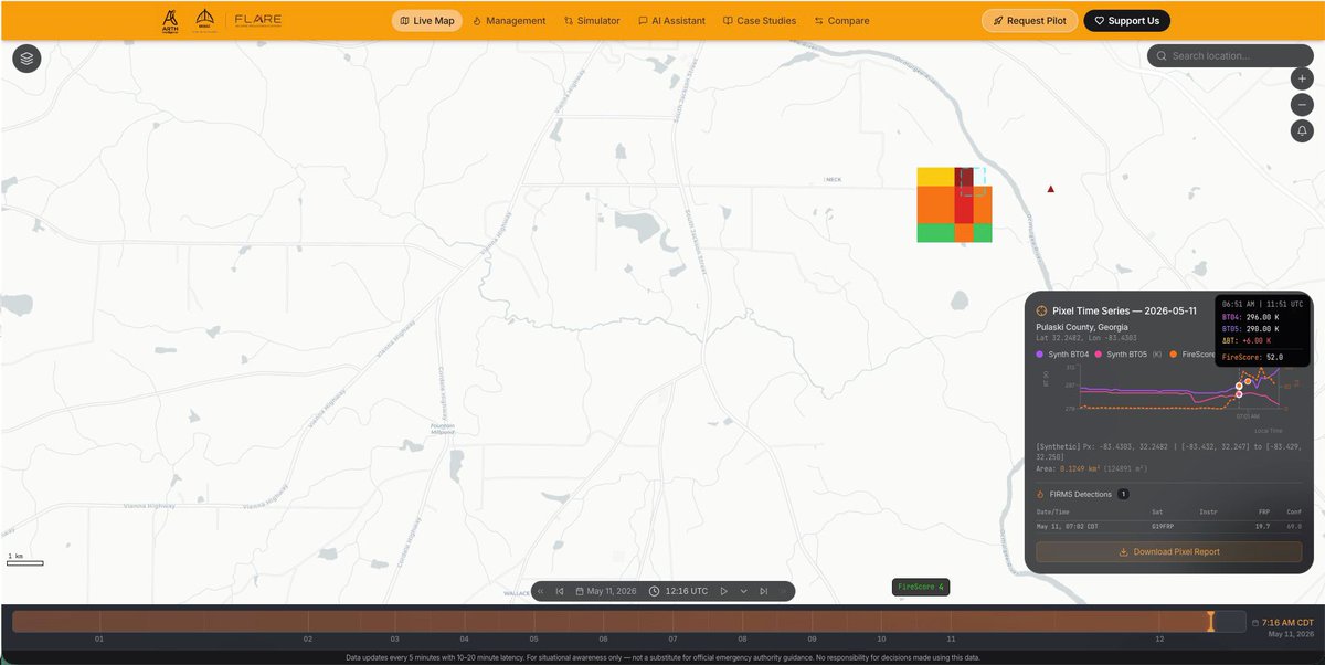
FLARE is actively monitoring a thermal anomaly in Pulaski County, Georgia (Lat 32.2482, Lon -83.4303).
Our FireScore began trending upward at 6:51 AM CDT, to 52 — flagged in real time and confirmed by FIRMS detection data.
P.S: At the time of posting this, FireScore went to 80.
From emergency management to climate risk underwriting, real-time wildfire intelligence has never mattered more. Here's why the gap between data and decisions is still dangerously wide.
#WildfireIntelligence#RemoteSensing#EmergencyManagement#GeospatialAI#ClimateRisk #WildfireResponse #PublicSafety #WildfireRiskModeling #NaturalHazardInsurance
In a war, one benefit of being totally confused about what you want to achieve is it leaves your enemies totally confused about what you want to achieve.
A signal appears → persists → gets confirmed → and you’re alerted while it’s happening.
Not hours later. Not after escalation.
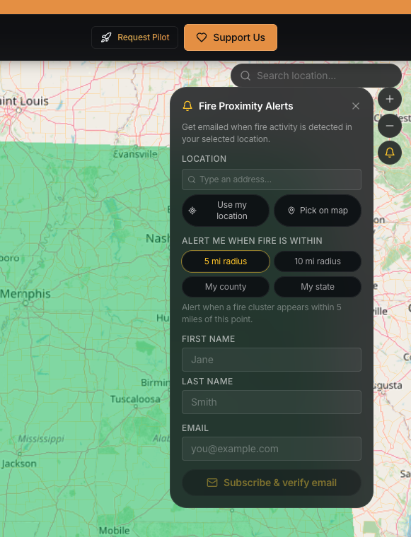
Now opening up location-based alerts to users, with expansion underway.
Early signals matter. That’s the layer we’re building.
Subscribe for alerts ↓
https://t.co/VjxL99wXrn
For partnerships or support, reach out: [email protected]@weatherchannel@accuweather
#Oklahoma #wildfiredetection #NWS #NOAA #FEMA #BRIDGEResearch #FLARE
Fire activity detected and tracked in Okfuskee County, OK.
FLARE monitored signal persistence, confirmed the event & issued alerts during active conditions.
Users can now subscribe to proximity-based alerts:
• Location/county/state
• Custom radius alerts (5-10 miles)
NWS advisories called for vigilance.
FLARE turned that into real-time alerts.
Persistent thermal signals → confirmed fire clusters → delivered directly to users.
This is what early warning infrastructure should look like.
Check out: https://t.co/0BLKomTgxs
#NWS#Wildfire #AlabamaForestryCommission #NOAA #FEMA
2 active fire clusters detected in the last hour — including Greene County, AR.
FLARE alerts trigger on confirmed, persistent thermal activity (~25 min) and deliver real-time intelligence for response.
Now live.
Sign up ↓ https://t.co/7dbizUCyKF
@NWSMemphis @ArkForestry
@NWS advisories called for vigilance.
FLARE turned that into real-time alerts.
Persistent thermal signals → confirmed fire clusters → delivered directly to users.
This is what early warning infrastructure should look like.
#wildfiredetection#FLARE#BRIDGEResearch#NOAA #Climatetech @EarthObservation
2 active fire clusters detected in the last hour — including Greene County, AR.
FLARE alerts trigger on confirmed, persistent thermal activity (~25 min) and deliver real-time intelligence for response.
Now live.
Sign up ↓ https://t.co/7dbizUCyKF
@NWSMemphis @ArkForestry
We’re monitoring fire activity across the Southeast and Central U.S. in near real time at ~375 m resolution through FLARE.
Explore the platform: https://t.co/VjxL99wXrn
Watch the video: https://t.co/y90yv7AKPh
Interactive demo: https://t.co/4Cnqd4Wtx1
A lot of wildfire intelligence still stops at detection.
A point appears on the map. A timestamp is recorded. An alert is generated.
But the real operational question is what happens next.
Does the signal intensify? Does it cool down? Does it spread beyond the original pixel? Is it sustained, or was it momentary?
That is where continuous monitoring becomes critical.
FireScore, built by BRIDGE Research and Policy Foundation through FLARE, is designed to move beyond one-time alerts and toward ongoing tracking. At roughly 375 m resolution with updates every 5 minutes, it helps reveal how thermal activity evolves over time.
This shift from static detection to dynamic tracking has real implications for emergency response, utilities, public agencies, and risk planning.
Explore it here: https://t.co/VjxL99wXrn
#Wildfire #ClimateTech #EarthObservation #RemoteSensing #FireDetection #ClimateRisk #DisasterResponse #GeospatialAI #FLARE #BRIDGEResearch #Oklahoma #OklahomaForestryServices #OklahomaEmergencyManagement #USForestService #USGS #PublicSafety #OklahomaMesonet
At 10:32 CDT, a satellite detection flags a fire.
But did it grow? Cool down? Spread? Most systems cannot tell you.
FireScore can. At ~375 m resolution & 5-minute updates, it tracks fire as it evolves.
This is the difference between detection & tracking.
https://t.co/7dbizUCyKF
FLARE provides a capability that doesn’t exist yet at scale. FireScore isn’t just about detecting fires. It’s about tracking how they emerge,evolve and intensify minute by minute.
Check out : https://t.co/7dbizUCyKF
#Wildfire#Oklahoma#ClimateTech#AI#FLARE#BRIDGEResearch
March 13–14 brought hot, dry, fire-prone conditions across the Southern Great Plains.
FLARE tracked multiple fire activity signals with synthetic brightness temperature updates every 5 minutes at ~375 m resolution.
The smoke is the downstream story.
We watch the source. #Wildfire
With FLARE, we’re advancing wildfire science — 5-minute satellite cadence, ~400m resolution, and forward-looking risk analytics to help emergency planners & managers act with confidence.
Explore how BRIDGE is driving wildfire resilience. 🔥🌍
https://t.co/hsFuIA7CvY
With FLARE, we’re advancing wildfire science — 5-minute satellite cadence, ~400m resolution, and forward-looking risk analytics to help emergency planners & managers act with confidence.
Explore how BRIDGE is driving wildfire resilience. 🔥🌍
https://t.co/hsFuIA7CvY
Detecting Thermal anomaly at 15-20 min latency using FLARE (https://t.co/tb3EEpk1C9)
McCurtain County, Oklahoma (Feb 23, 9:51 AM CST)
Lat - 33.8463, Lon - 94.7466
Detecting Thermal anomaly at 15-20 min latency using FLARE (https://t.co/tb3EEpk1C9)
McCurtain County, Oklahoma (Feb 23, 9:51 AM CST)
Lat - 33.8463, Lon - 94.7466
Proud to share this work from @bridge_rpf
FLARE is about turning high-frequency Earth observation data into early, decision-relevant wildfire insight—when minutes matter most.
More coming soon. 🔥
#Wildfire#SatelliteAI#EarthObservation#FLARE
🔥 Ranger Road Fire | Feb 17, 2026
FLARE’s AI-based GOES–VIIRS fusion generates ~400 m synthetic thermal signals at a 5-min cadence—capturing rapid heat intensification as it unfolds.
Built for earlier situational awareness. More soon with the FLARE dashboard.
#Climatetech