A large Saharan dust plume has stretched across the Atlantic from the west coast of Africa towards the Americas. CAMS data shows that large parts of the Caribbean are most impacted.
We demonstrate in our new paper that shale tectonics off Niger Delta initiated early in the evolution of the system and that mud volcano systems once formed may act as conduits for pressure release throughout the history of a gravity collapse system. https://t.co/3toENZaF49
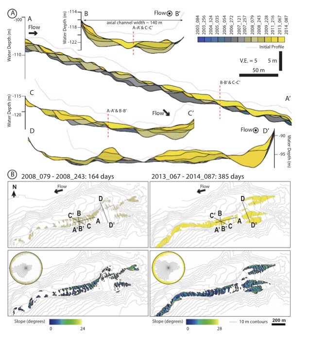
@rgenglert shows how stratigraphy is built in active submarine channels based on repeat seafloor surveys and then relates that to stratigraphy in ancient channel fill sequences to understand past flow regimes. Neat stuff!
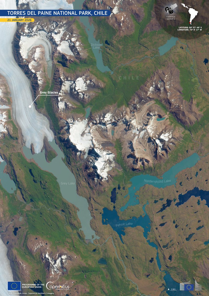
⛰️ Torres del Paine NP in Chile 🇨🇱 is known for granite peaks, turquoise lakes and vast ice fields.
🛰️ This #CopernicusEU Sentinel-2 #ImageaofTheDay shows Grey Glacier - helping scientists monitor glacier change and fragile mountain ecosystems.
🔗 https://t.co/XMpJnn4hsT
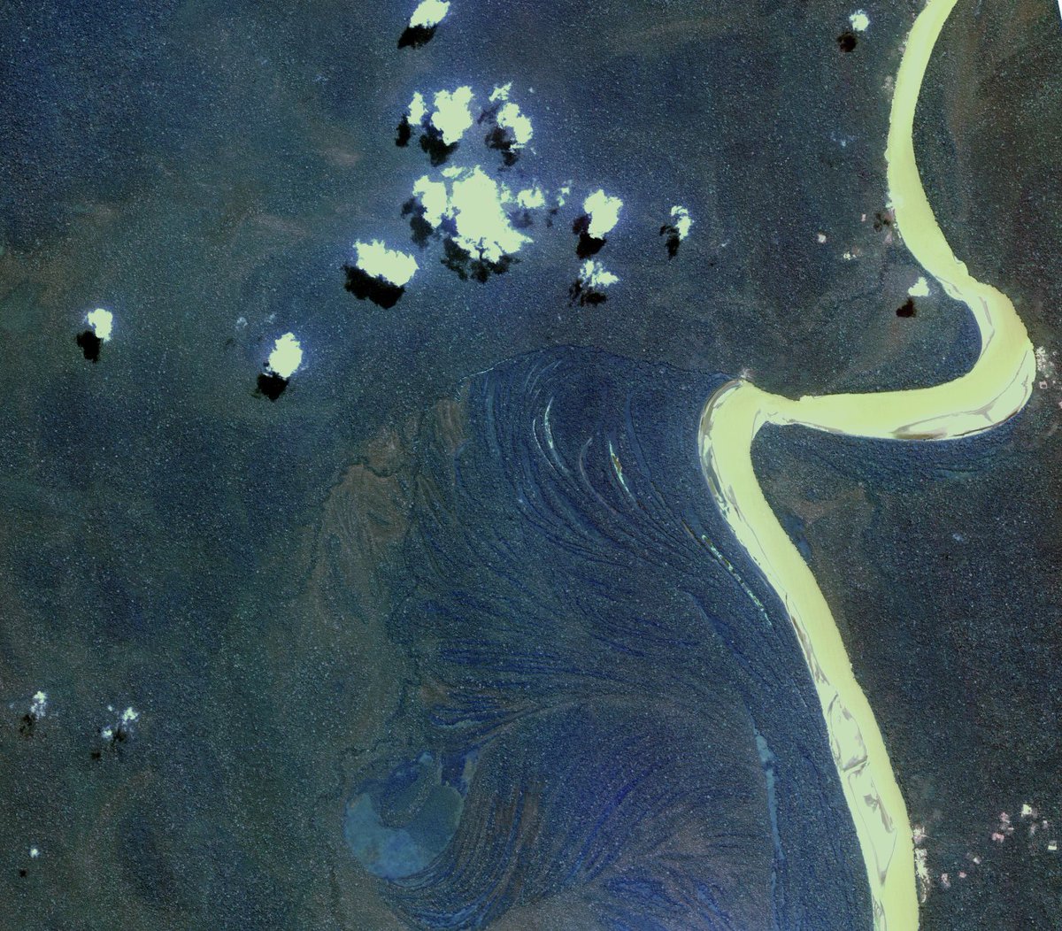
🌳 A section of the Madre de Dios River in the Bolivian Amazon, captured by 🛰️ Kompsat-2 in September 2011.
Bolivia is one of the world’s most biodiverse countries, yet since 1990 it has lost around 7 million hectares of rainforest due to logging and agriculture. The cyan area highlights a deforested zone — a visible sign of human impact.
🔍 Resolution:
▫️ PAN: 1 m
▫️ MS: 4 m (VHR: 0–5 m)
🎨 Spectral bands:
🗺️ PAN (500–900 nm): Surface feature identification
💧 Blue (450–520 nm): Shallow water mapping, soil vs vegetation
🌿 Green (520–600 nm): Vegetation health
🌱 Red (630–690 nm): Vegetation type differentiation
🌾 NIR (760–900 nm): Vegetation vigour and species mapping
✅ Explore the @esa Kompsat-2 collection:
https://t.co/WAYCyd5qQs
📷 @kari2030@ESA
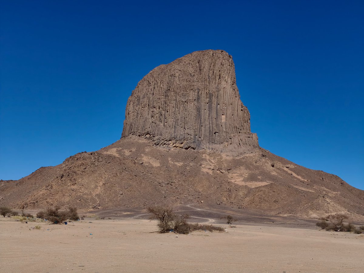
An interesting, self‑sponsored journey across the Sahara: at the northern Hoggar Shield, sands laid on outcropping formations in a display of Neogene aeolian erosion. Near Tamanrasset, Mount Iharen rises as a Miocene phonolitic plug, composed of basalts, trachytes and phonolites.
🛰️ This #CopernicusEU Sentinel-1 #ImageOfTheDay (20 Jan) shows wind-modulated sea surface conditions across the southern Tyrrhenian Sea during the passage of Storm Harry.
🔗 https://t.co/rx0o3wF1VB
Excited to share that in 2026 I will be progressing to a new role as a Turbidite Research Group associate. An incredible opportunity to contribute to an outstanding team of sedimentologists. Thanks to Dr. Adam McArthur for his amazing support.
Baiyun Mountain sits quietly in the Pearl River Basin, just north of Typhoon Ragasa’s path.
Glad to share a new step with the Guangzhou Marine Geological Survey; it may reshape how we read this basin.
https://t.co/cHyRSr3mIT
#Guangzhou#PearlRiver#Geology
Excited to share our new book with SWPU- professor Zhao's team on deep marine depositional systems!
Covers turbidites, channels, lobes, and key insights for geoscientists & sedimentologists.
The book is edited and published in Chinese!
Check it out 👉
https://t.co/uImgJ7akJN
Global satellite views illuminate our understanding of how rivers forge their paths, which is crucial for sustainable and safe land management along densely populated waterways.
Learn more this week in Science: https://t.co/IChoA9Y3XA
An unusual structure beneath the Baltic Sea. Interesting discovery of a stone wall that may have helped humans hunt 8,500 years ago.
https://t.co/y6CrLeps7D
Good study by Xuesong Zhou et al. on fault-bounding depocenters in a hangingwall dipslope setting—mapping basin geometry and rift evolution in the Eocene Xihu Sag, East China Sea.
🔗 https://t.co/f3y91JkupT
In addition, it raises questions about their consequences in structurally controlled channel bends by presenting a new approach to restore the structural framework during channel evolution.
Very interesting discussions at the TRG meeting! https://t.co/Bi0fnEkKvr - I presented on submarine channel bank failures and their impacts on long-term sedimentation and channel lateral migration/expansion. Thanks to @McTurbidite for leading this event. #Geology
This talk showcases different approaches, using 3D seismic records of the Niger Delta Fulani Channel, to constrain the role of wall collapses in the sedimentary fill and channel lateral migration.