Isolated thunderstorms affecting the Central Coast this morning. The small but stronger cells are producing a few lightning strikes with light rain. More cells possible through the day. If you see lightning or hear thunder, stay safe and head indoors until the storm passes. #cawx
24-hour time-lapse of the strongest storm on Earth: Hurricane Genevieve in the Eastern Pacific, which briefly reached Category 5 intensity at its peak last night.
🕑 Adv. 12 at 2026/07/27 02:00 MST | Current status: 🟣 Category 5 hurricane | ⏫ 160 mph (260 km/h) | ⏬ 925 mbar (27.32 inHg)
Absolutely bestial.
#Genevieve has become a Category 5 #hurricane tonight; the first since Kristy 2024.
Maybe she won't be the only Cat. 5 this season.
📷: CyclonicWx
⚠ We are monitoring the Burro Fire in the Angeles National Forest, & we are also aware of the Sandy Fire in Ventura County. ⚠
https://t.co/xbCgyL5GcR will be updated as needed for any wildfires within or impacting #LACounty.
1/2
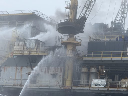
USCG, SB Harbor Patrol, SB County Fire, SB City Fire & Ventura County Fire are responding to a fire on platform HABITAT 7.5nm off Santa Barbara. All 26 crew evacuated safely. A 1000 yard safety zone is in effect around the platform. Updates will be made as available.
This #WildfirePreparednessWeek, remember that wildfire risk in California is year-round, and conditions are already getting drier.
•Protect your home
•Clear the first 5 feet around your house
•Build an emergency kit
•Sign up for alerts
•Plan your evacuation
Small steps now can make a big difference later. Wildfire safety starts with all of us.
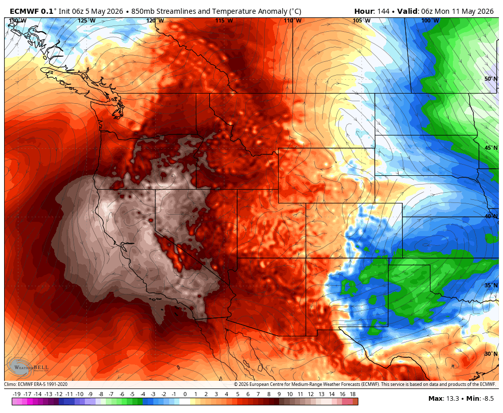
After a chilly and damp last two weeks in California, a severe early-season heatwave will arrive this weekend.
Sacramento could flirt with 100°F on Monday, temperatures could reach up to 105°F in the San Joaquin Valley, and Death Valley could exceed 115°F.
🔥 Hope Ranch ‘Volcano’ Update: 4200 block Marina Dr SB
Fire crews from Santa Barbara County Fire (@SBCFireInfo) and Santa Barbara City Fire (@sbscityfirepio) are on scene in Hope Ranch addressing activity from the local geological phenomenon known as the ‘Hope Ranch Volcano.’
This is not a true volcano, but a natural solfatara—a vent in the coastal bluffs that releases heat, steam, and sulfurous gases due to ongoing chemical processes in the underlying rock formations. Documented since the 1800s, it periodically flares up and can ignite vegetation or nearby materials.
Today, the activity has caused a smoldering fire in an underground PVC drainage pipe, producing visible drift smoke in the immediate area. Crews stopped forward progress immediately and are now working to fully mitigate the underground pipe. No structures are threatened.
Residents may notice lingering smoke; please avoid the immediate vicinity while crews complete their work. Thank you to our firefighters for their rapid and effective response!
#SantaBarbara #HopeRanch #SBCFD
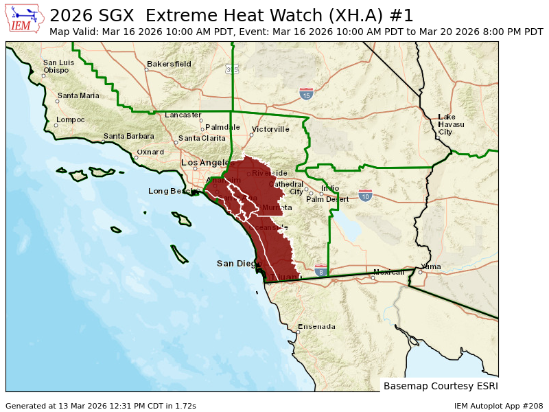
NWS San Diego has issued an Extreme Heat Watch for the Inland Empire, Orange County, and much of San Diego County. This is the first extreme/ excessive heat watch issued in the month of March in California. If it is updated to warning, it will be the earliest of such in state history.
Temperatures will be 85-90°F near the coast and up to 105°F inland Monday through Friday.
NWS Los Angeles also mentioned the potential for an extreme heat warning in their discussion. #CAwx
HAPPENING NOW ‼️‼️‼️‼️
#SantaBarbara / #California
Supercell rotation as a heavy thunderstorm makes landfall in Santa Barbara County. Not clear if the rotation ever made it to the ground
🔎Check out rainfall countywide over Thursday evening and into Friday morning!
💧The highest rainfall captured is over 5 inches at the Alisal Reservoir.
🌧️Interested in how much rain we're getting or how creeks are holding up? Visit https://t.co/kNJ3ZaoehX
#SantaBarbaraCounty
Watch #Melissa meander on a path right through some of the hottest (deep) waters on the planet, powering one of the strongest hurricanes ever, then leave a cool wake behind as it turns hot water into power to charge its rain and wind.
The #caribbean in October is notorious for monster hurricanes and Melissa literally moved over the hottest waters not just in the Atlantic but also in the entire Caribbean.
How it ended up there is part luck, part climatology, and - in a local sense - partly that storms without steering can sometimes be tugged towards areas with the greatest heat/ instability.
#hurricane #fyp #jamaica
This footage from inside the eye of Category 5 Hurricane Melissa might be the most jaw-dropping video ever captured of a hurricane’s eye, showcasing the infamous “stadium effect."
TORNADO WARNING just issued for San Luis Obispo and surrounding towns for severe thunderstorms making landfall that could produce tornadoes.
We are witnessing a historic severe thunderstorm event for the Central Coast and Southern California.
A prolific thunderstorm outbreak is ongoing across California’s Central Coast, with thousands of strikes recorded over the past 12 hours.
Thunderstorms are much further north than was expected by this time near Carmel and could reach the Bay Area soon.
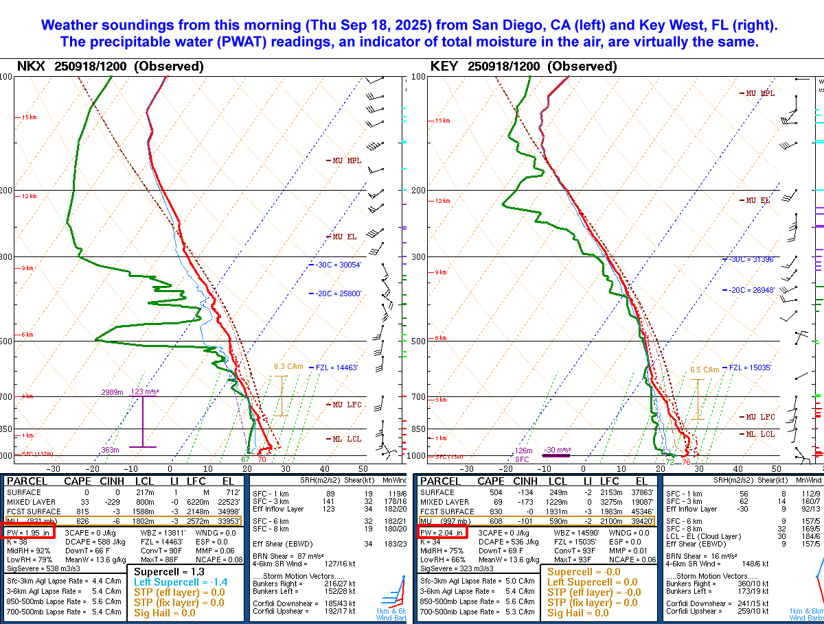
Welcome to Florida: the moisture in the air from the morning weather balloon reading at San Diego is virtually the same as the reading at Key West. It will be muggy out there. Off and on again showers to continue as well, with isolated thunderstorms. Expect slick roads. #cawx
With the upcoming shower/thunderstorm chances, the most hazardous impacts Wed into early Thur will be dry lightning & localized strong winds. As more moisture arrives Thur, the threat shifts to flooding & potential for debris flows in and around recent burn scars. #socal#carain