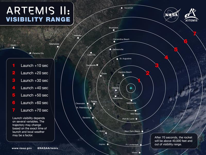
Can you see our Moon rocket lift off from your backyard?
Skywatchers in Florida and southern Georgia will have a shot. Check out this map to see when you should look up! Artemis II is targeted to launch no earlier than April 1.
Hail is very non-uniformly distributed around the world.
For much of the world, you almost never see hail large enough to damage solar panels. The central USA does have some issues though.
https://t.co/LB3lohEdRn
Cape Verde-type hurricanes are those Atlantic basin tropical cyclones that develop into tropical storms fairly close (<1000 km [600 mi] or so) of the Cape Verde Islands and then become hurricanes before reaching the Caribbean. Typically, this may occur in August and September.
Last night, the 53rd Weather Reconnaissance Squadron flew into the eye of Hurricane Erin—and captured imagery of the breathtaking stadium effect.
These missions provide critical data to the NHC to improve forecasts, helping keep communities safe before the storm makes landfall.#readynow #weatherready
The latest low-level water #vapor imagery and model output low-level winds reveal a robust tropical wave near the Cabo Verde Islands. The wave is inside a #moist envelope with cyclonic motion. NHC will monitor this wave closely as it moves westward over the next several days.
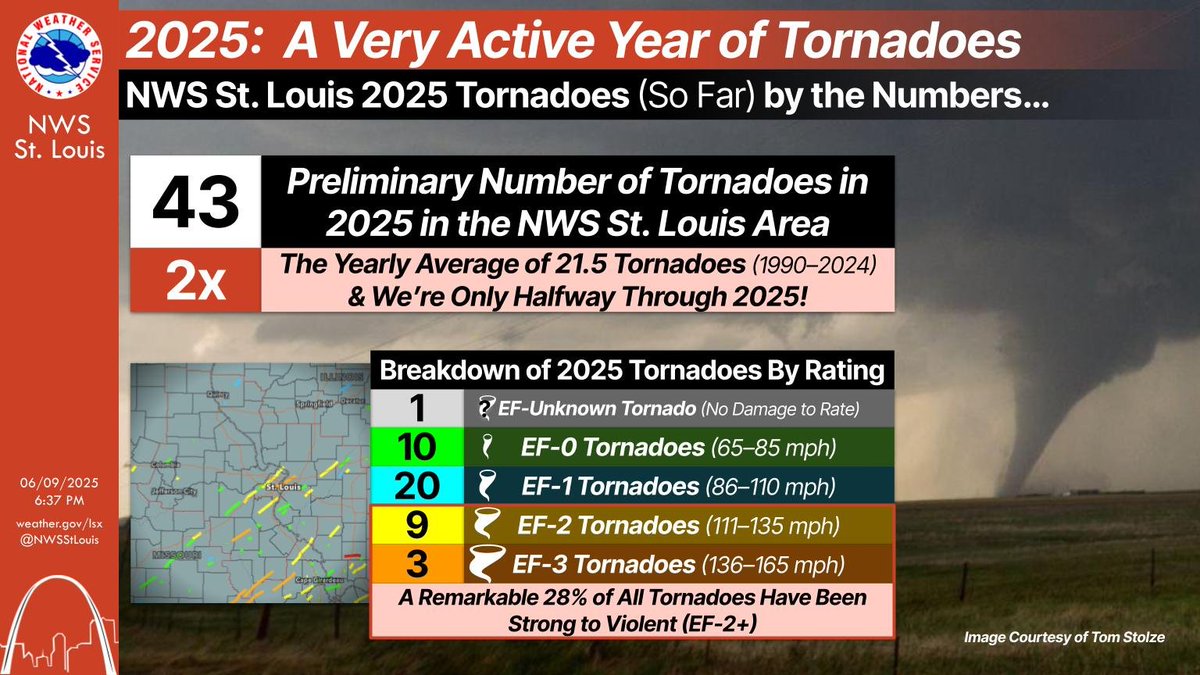
If you’ve noticed that there have been a lot of tornadoes so far this year, you're not wrong! We have seen double the yearly average & we’re only halfway through 2025. Additionally, a remarkable 28% of these tornadoes have been strong to violent (EF-2+).
#stlwx#mowx#ilwx
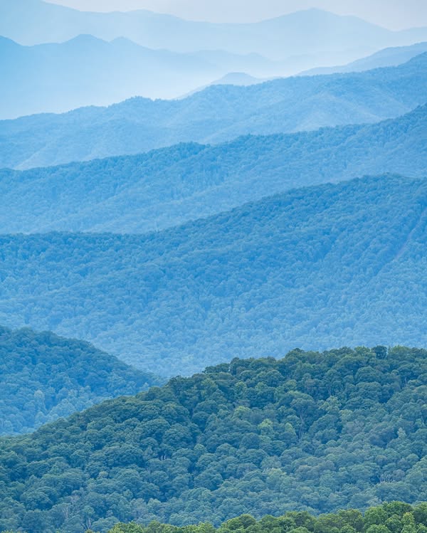
Summertime is back in the Blue Ridge Mountains of North Carolina! The mountains appear blue because specific oak and poplar trees here emit a chemical called isoprene to protect them against excessive heat.
Photo Credit: @AshevillePictu1#ncwx
5/31 - Showers and thunderstorms along the western coast of Africa are associated with a new tropical wave that is moving into the eastern Atlantic Ocean. The wave is moving westward at 10-15 kt.
Stay updated on marine conditions at https://t.co/26J6Uogt6o #marinewx
This image highlights two regions in the Atlantic hurricane basin that are favorable for easterly wave generation and growth: Africa and the Caribbean. One reason for this is an instability resulting from horizontal shear, called barotropic instability...
You can see the southernmost supercell in Missouri spinning like a top on GOES-19. These storms will have hours to take advantage of a volatile and relatively rare environment for this part of the country.
Today, May 15, marks the first day of routine issuance of the Atlantic basin Tropical Weather Outlook in 2025. The tropics look quiet for the next 7 days. Visit https://t.co/tW4KeGdBFb for updates.
I've finally gotten around to making the "SE Florida landfalls" composite 500-hPa pattern using ERA5 data (instead of the sketchier older reanalysis). I also expanded it to all hurricanes (not just major) in the dataset.
The composite pattern shows a ridge over New England with troughing over the Rockies. Individual storms have a variety of patterns, but some sort of ridging to the N, and no ridging over the desert SW (which blocks storms from moving west) seem key to getting a FL hit from the east.
Next, I want to examine the pattern a few days before landfall (to see how persistent it is), compare with "near miss" cases (like Dorian/Matthew/Floyd/Irene), and put everything together in a paper.








![NHC_TAFB's tweet photo. Cape Verde-type hurricanes are those Atlantic basin tropical cyclones that develop into tropical storms fairly close (<1000 km [600 mi] or so) of the Cape Verde Islands and then become hurricanes before reaching the Caribbean. Typically, this may occur in August and September. https://t.co/bN5uXoYnRi](https://pbs.twimg.com/media/GzcSDlaXQAAer_F.png)