Outside of storms sustained winds of 25 to 30 mph with wind gusts of around 40 mph are expected Friday afternoon through Saturday. Some downed trees and power lines will be possible.
Severe storms capable of tornadoes, widespread damaging winds, and large hail are likely late Friday night through early Saturday. A few tornadoes could be strong. Stay tuned for more updates and make sure you have a plan in place for this potential severe weather event!
Significant severe storms are likely now through tonight. Tornadoes, some possibly strong, damaging wind gusts, and large hail are likely. Everyone needs to stay weather aware and have your severe weather plans in place today! #mswx#lawx#arwx
New outlook from SPC… Upgrade to moderate risk (level 4/5) over parts of MS/LA. Most of Alabama in a slight risk (level 2/5). Storms later today/tonight could produce hail, damaging wind, and a few tornadoes… Possibly a strong tornado in the moderate/enhanced risk areas
Severe thunderstorms are anticipated across parts of the Lower Mississippi Valley and Deep South with tornadoes and damaging winds as the primary hazards. Peak tornado risk is expected through early evening, centered on northern and central Louisiana into central Mississippi
❗ UPDATE ❗
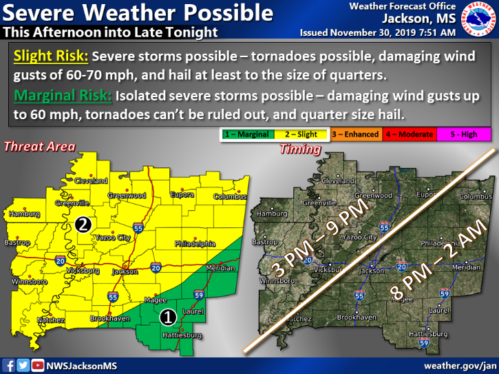
The 'Slight Risk' has been expanded further east. Check to see which threat area your county falls in!
Timing will still be the same: Storms moving into the area in the late afternoon, progressing eastward through the evening and overnight. #mswx#lawx#arwx
Here is the last 2 minutes of coverage before the Columbus, MS #tornado touched down. The @WCBINEWS staff had to evacuate to the basement since the touchdown was just a block or two down the street. Power was lost which ended our coverage. https://t.co/899fJrrMOa #mswx