This is a spent Chinese Long March 3B rocket body, imaged by a Vantor WorldView Legion satellite from 88 km away.
The image quality is not simply about range. It reflects the strength of Vantor’s advanced WorldView constellation and high-performance imaging hardware, which enable detailed observation of objects in orbit.
It’s a powerful example of Vantor’s NEI tasking through our WorldView Space product line: using high-resolution satellites to look out into space and capture detailed imagery of objects in orbit.
Why does that matter? Most tracking systems can show where an object is. WorldView Space NEI helps show what it is, its structure, orientation, condition, and potential risk. It can also support Movement Analysis, helping operators understand whether an object is intact, tumbling, spinning, or otherwise changing behavior over time.
That level of detail is especially important for large rocket bodies like this one. They are big, long-lived debris objects that share orbits with critical infrastructure, including communications, Earth observation, weather, science, and national security satellites. A single collision involving an intact rocket stage can create thousands of new fragments, increasing risk across already crowded orbital regions.
As launch activity accelerates, we need to understand not just where objects are in space, but what they are, how they are moving, and how they may behave over time.
This is the rideshare adapter that carried 143 satellites on Transporter-1.
On January 24, 2021, SpaceX's Falcon 9 launched 143 spacecraft to orbit on a single vehicle, setting a record that still stands today.
HEO's Continuum-1 imaged the adapter from 60km away, at 13cm/pixel resolution, over the Arctic Ocean.
I'm not sure why, but I *love* upper stages in space. It is just something about them. You never really see them on their own, unless there is a separate camera. There is something surreal about it.
Very related, @NASAAdmin, do you know when the A2 ICPS pictures will be posted?
Attempt to fit Starship FT12 orbit from webcast data: I estimate -7 x 194 km x 28 deg with an uncertainty of about +/- 8 km on that perigee value, so between -15 and +1 km.
When HEO acquired Continuum-1, we committed to using it to catalogue objects in low-Earth orbit (LEO). Part of that work means turning attention to derelict hardware.
As noted in the recent issue of the @IntegrityISR Flash, CZ-6A upper stages are a growing concern to the sustainability of LEO as they have produced some of the largest fragmentation clouds in LEO in recent years. These rocket bodies are left in orbits that will take years to decay, with no means of manoeuvre and no plan for removal.
This is one of them.
Continuum-1 imaged this CZ-6A rocket body in orbit. It is the upper stage from the October 31, 2023 launch that carried the Tianhui 5A and 5B satellites. It appears largely intact and is gravity-gradient stabilised.
Images like these establish a baseline. If the object's state changes, that deviation is observable and comparable against something real. Attribution is rarely straightforward after a fragmentation event. A prior record can make the difference between knowing something happened and knowing why.
Reference: https://t.co/gQsYA6QNFc
HEO has a #NoUFOPolicy.
Objects we image leave with an identity and characterisation, as it is critical to identify space objects to maintain space and Earth safety.
For example, this object is currently listed as Object A in public tracking databases, a designation assigned to newly launched objects pending formal cataloguing.
HEO has imaged and characterised it as the Lingxi 03 communications satellite, a designation corroborated by publicly available information on the mission.
When identities and capabilities in orbit remain obscure, whether by cataloguing lag, sparse public data, or the absence of independent characterisation, operators work with an incomplete understanding.
Unknown no longer has to be a permanent state.
*Measured in the 2D image plane. Any extension into the image plane is not captured, so this figure represents a minimum. The true length may be greater.
2026 JN2, a very small object (about 1 meter or less) (see MPEC 2026-J143), discovered by JPL's SynTrack robotic telescope on May 15, 2026, at 10.34 UT, impacted Earth. According to my calculations, the impact occurred on May 15, at 13:36 UT, in the area shown on the map below.
The five payloads launched on the May 15 Lijian-1 have been tracked by Space Force in 525 x 542 km sun-sync orbit iwth 11:00 local time orbital plane; upper stage in a 292 x 539 km orbit. Dragon CRS-34 tracked in 208 x 305 km x 51.7 deg, on its way to ISS.
Time lapse video of the chinese rocket fuel dump last night from my auroracam livestream - 05.14.2026 ✨ from Marquette, Mi over Lake Superior - dot on horizon is freighter Joseph L. Block
Two objects cataloged from the Zhuque-2E launch in 209 x 872 km x 89.0 deg orbit. The parameters are consistent with the theory that this is the SECO-1 orbit, the second stage failed to restart, and the payload then separated.
According to a meeting held yesterday, currently KSLV-II Nuri FM5 building is 70%-90% completed, aiming for the launch on 3rd quarter, 2026.
It will put NEONSAT-2 to 6, and 10 piggyback cubesats (total mass of abt 570kg, without adaptor) into 500km SSO.
https://t.co/hczywvEA6q
ZhuQue-2E fuel dumping. The preferred noon launch window local time China, and polar orbit, would send the upper stage crossing America at midnight local time. These would be more and more frequent in summer
Looking good, ViaSat-3 F2! 📸🛰️🌎
This amazing photo of our ViaSat-3 F2 fully deployed large reflector was taken in space – 22,236 miles above Earth.
Exciting progress for our ViaSat-3 program, as we focus on advancing in-orbit testing of our ultra-high-capacity satellite.
The Artemis II images browser is in a much better shape now, with separate collections for Earth, Moon, and Eclipse images. A complete scientific data archive prepared by the lunar science team and peer-reviewed is to be released through PDS.
https://t.co/Hy4m8oSwOR
#Artemis
Thanks to @Dillonshrop06 we have an awesome video of JAXA's HTV-X1 captured from Northwestern Pennsylvania May 12th at an altitude of 376 kilometers. HTV-X1 launched in October 2025 aboard an H-3 rocket from Tanegashima Space Center, Japan where it later rendezvoused with the International Space Station. HTV-X1 then undocked with the ISS on March 6th 2026 and entered 'free-flyer' state. HTV-X1 will de-orbit 'No Earlier Than' later this month in the south Pacific Ocean where it is expected to demise.
Moscow-based small satellite developer proposes the "world's first distributed solar observatory" comprised of cubesats spread from Earth's orbit to Lagrange points.
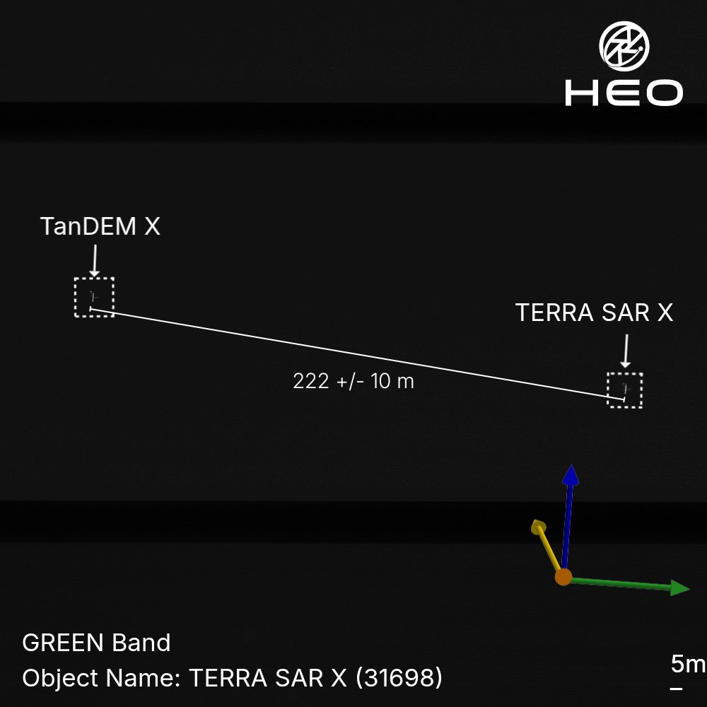
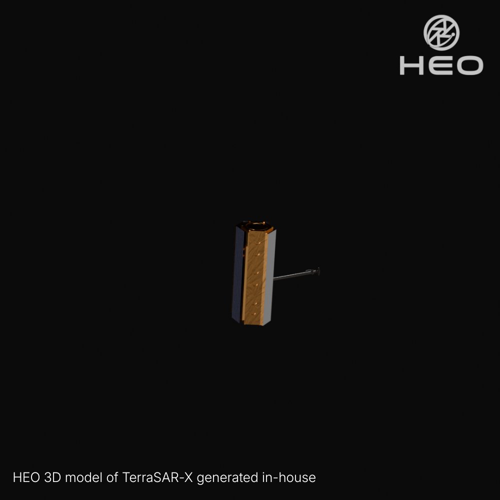
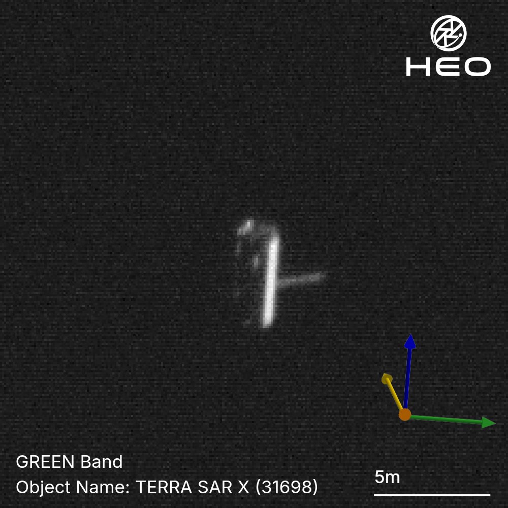
Most satellites operate alone. These two are a duet.
TerraSAR-X and TanDEM-X are among the most precisely coordinated formation-flying satellites ever operated. Launched three years apart, Germany's TerraSAR-X in 2007, TanDEM-X in 2010, they orbit in lockstep at ~508 km altitude, separated by just hundreds of metres while travelling at over 27,000 km/h.
Together, one transmits and both receive, forming a large single-pass SAR interferometer that has produced a high-precision global digital elevation model (DEM) of Earth's entire land surface.
Here, we captured both satellites in a single frame, at least 222 metres apart.
While a single image shows what a satellite looks like at a moment in time, by imaging it repeatedly, we build a deeper understanding of how it operates, how it's configured, and how it behaves in space.
*Measured in the 2D image plane. Any separation into the image plane is not captured, so this figure represents a minimum. The true distance may be greater.