I love anime and manga. I love my family and three children and three crazy cats. I feel like I have a pretty great life. Nothing rly special just normal.
Trainers, please note that Pokémon Trainer Central will be conducting a maintenance update for approximately 60 minutes on August 19th at 10am PST, and will be unavailable to use to log into Pokémon GO. We recommend adding an additional login provider to your account to ensure you don’t lose access to Pokémon GO during this time: https://t.co/cwKTqPiGbI
✨ Pokémon Horizons Shiny Hunt ✨
Decent little shiny hunt for the event to celebrate the release of Pokemon Horizons: The Series! Pikachu will probably only be released for this event so definitely shiny check plenty of them! ✨
Severe thunderstorm gusts -- some reaching at least 75 mph -- are possible from this afternoon into early evening over portions of the central High Plains.
Visit https://t.co/VyWINDkBnn for the latest.
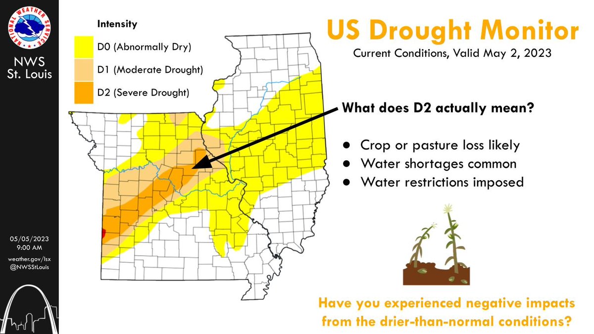
Due to the very dry conditions since the start of April, drought has re-emerged across parts of the area. Portions of C/NE MO have been most impacted, with severe (D2) drought now in these locations. #midmowx#mowx#ilwx https://t.co/2isvnAlNjH
**3 AM UPDATE**
Two areas of t-storms are impacting the forecast area overnight. T-storms are continuing along the cold front in western MO, slowly making their way eastward. Another area of t-storms has developed across SE MO and is moving NE. #mowx#ilwx#stlwx#midmowx
Another threat of severe storms will occur mid-late TUE evening - WED AM along and ahead of the advancing cold front. All severe weather hazards will be possible incl. large hail, damaging winds 🌬️, and tornadoes 🌪️. #stlwx#mowx#ilwx#midmowx
The planned St. Louis Doppler radar outage has been DELAYED until April 6th, due to the threat of severe weather on Friday & the potential for active weather to continue early next week.
#stlwx#mowx#ilwx
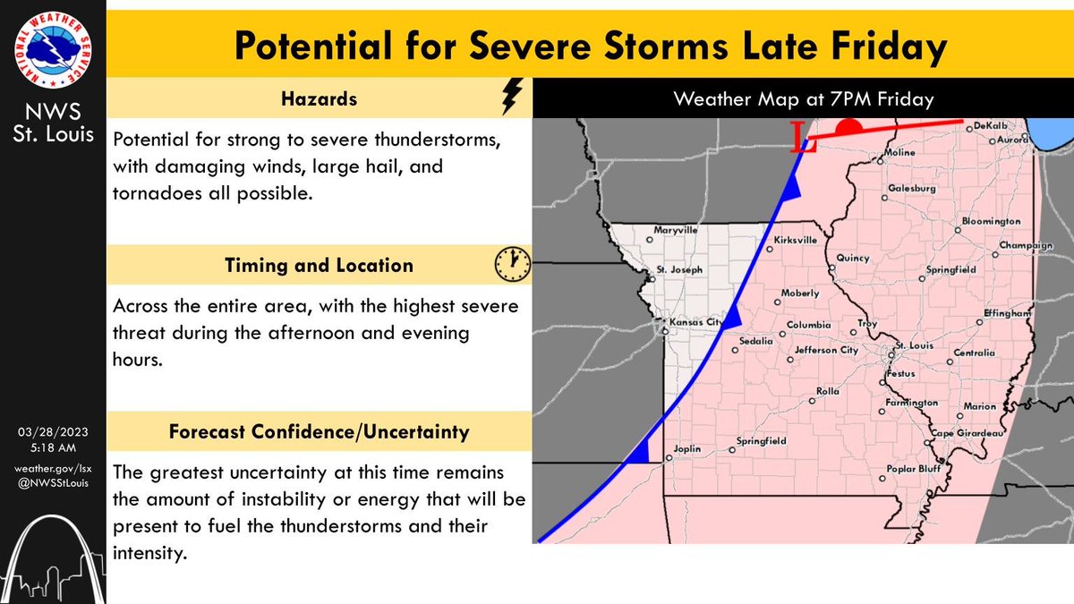
A cold front is expected to move thru late FRI, bringing a round of showers + thunderstorms 🌩️. Some of these storms may be strong to severe, w/ the main question mark continuing to be how much instability (energy) will be available. #stlwx#mowx#ilwx#midmowx
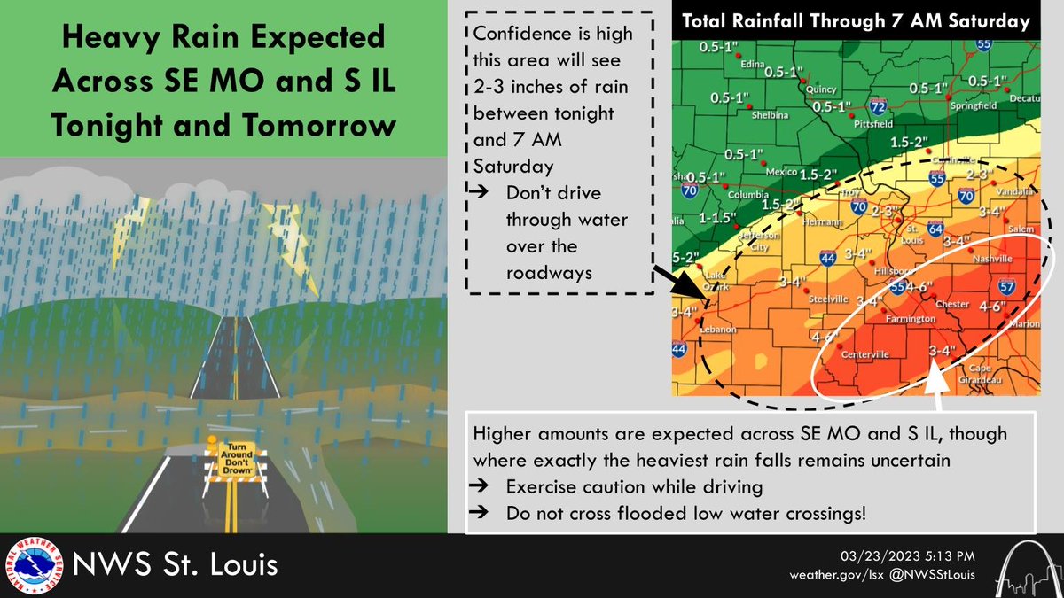
Confidence is high that 2-3" of rain will fall across portions of central, east-central, and SE MO & SW & S IL through 7 AM SAT. Higher totals are expected across SE MO and S IL.
Do NOT drive into water over roadways, including at low water crossings #mowx#ilwx#stlwx#midmowx