Station Agent is officially live! Thank you to everyone who helped get this project off the ground. Enjoy at your own leisure or tune in while you bet on the climate markets!
https://t.co/iuhLtLfYP5
A line of light to locally moderate rain is moving through this morning. Some additional light showers are possible through early afternoon but expected to dry out later afternoon into the evening. Some partial clearing will be possible toward evening as well.
Unseasonably warm conditions are expected today with mostly sunny skies and gusty west winds to 20-25 mph developing. Highs will soar well into the 80s, except 70s along the immediate south coast and Cape Cod.
Severe storms are likely this afternoon and evening across parts of the central Plains. Large hail, damaging winds, and perhaps a couple of tornadoes will be possible. Dry and windy conditions with lightning and dry thunderstorms may support hazardous fire activity across the Southwest into the southern High Plains.
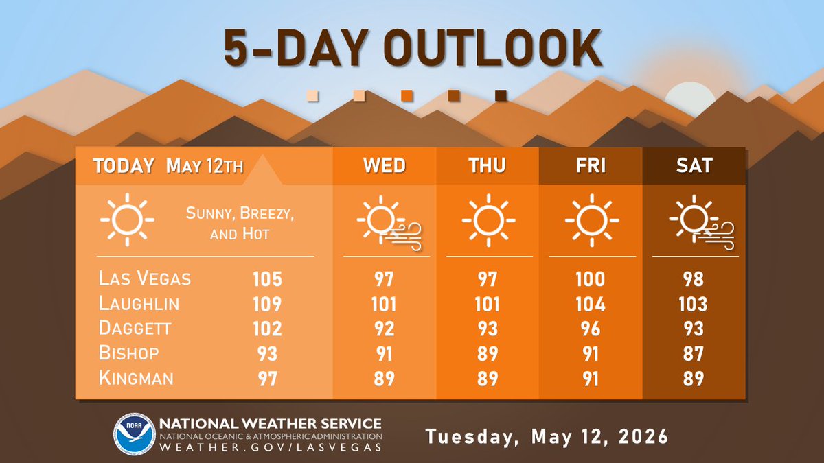
Above normal temperatures will persist through Saturday with highs around 100°F. A weather system will bring increased winds this weekend, likely leading to elevated to locally critical fire weather conditions. Highs will also cool down into a 90-95°F range by Sunday. #azw#cawx
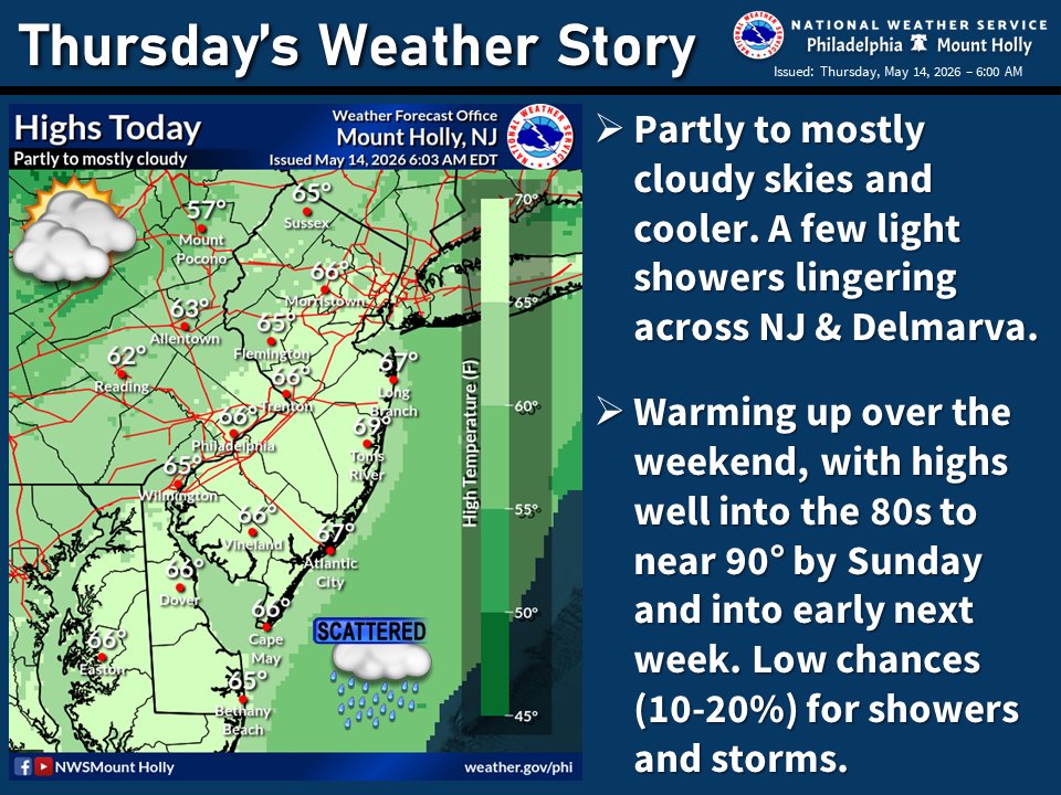
🌥️ Cooler today with highs mainly in the 60s under partly to mostly cloudy skies. A few light showers lingering across the eastern half of the area. A big warm up is on the way this weekend, with low chances of showers and storms through early next week. #PAwx#NJwx#DEwx#MDwx
Very typical temperatures with lows in the 60s and highs in the mid 80s will be in place to close out the week. Mostly sunny skies will also be in place through Saturday.
Showers develop across the area tonight and continue through the day on Thursday. Locally heavy downpours and a few thunderstorms are possible. Rainfall tapers SW to NE Thursday evening.
Showers & some isolated thunderstorms have started to develop over the northeastern Olympic peninsula this evening. Showers will increase across the area over the next several hours & isolated thunderstorms will remain possible tonight. When thunder roars, go indoors! #wawx
Unseasonably hot conditions continue, with gusty winds today and tomorrow as well as on Saturday. Temperatures midweek and Saturday will be slightly cooler, but still well above normal. Be sure to keep heat safety in mind, especially if you’ll be outdoors! 🥵
#nvwx#cawx#azwx
It's a little early to get too specific on the forecast for Memorial Day weekend, but here is the latest 8-14 day outlook that covers that period from @NWSCPC. As you can see, above normal temperatures are favored in the East in that time period.
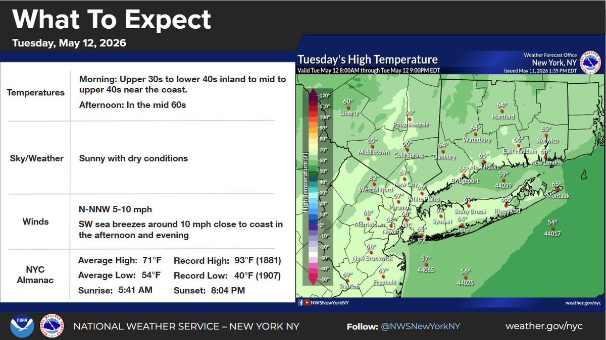
Tuesday will start out cool, but should become mild under sunny skies. High temperatures reach the mid 60s for much of the area. There will be a breeze out of the N-NW 5-10 mph and immediate coastal locations should see a SW sea breeze develop in the afternoon.
Storms are currently moving into our area and we are looking for reports as they move across the area. Tag us if you do have a report to share and please include the time and location. Only go outside if it is safe to do so to report any hail or wind damage. #txwx
Mainly dry weather through Tuesday, then rain chances increase Wednesday afternoon and especially Wednesday night into Thursday. The trend will be for drying conditions Friday, but a few showers may linger.
Cooler temperatures will continue into Monday with highs in the upper 50s and 60s. Warmer and windy conditions then develop on Tuesday with a cold front bringing shower and thunderstorm chances back to the area. #ILwx#INwx
One more round of frost/freeze is expected tonight, followed by a warming trend which will continue through late this week. Precipitation chances will be few and far between, mainly late Monday night into Tuesday morning and possibly again Thursday night. #mnwx#wiwx
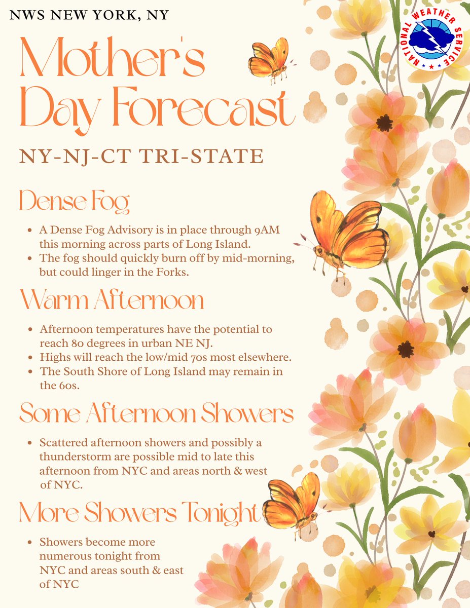
Happy Mother's Day! Dense fog along the coast should burn off by mid-morning. Then, this afternoon we'll see warmer weather with much of the area warming into the 70s. Scattered showers are possible N&W of NYC this afternoon, becoming more numerous tonight at the coast.
A warmer day is expected for Mother's Day, with highs in the 70s for much of the forecast area. 60s can be expected along the South Fork of Long Island and SE New London in CT.
There will be a chance for more showers, but not nearly as widespread as they were today.