Dr. Theresa Crimmins @uarizonasnre will be honored today as one of 30 @uazresearch Women of Impact 🔬 👩🔬 The @USANPN she leads collects and stores long-term phenology datasets for both scientists + non-scientists to understand impacts of climate change. Congrats @TheresaCrimmins!
I am so proud of all that @USANPN has accomplished, it's a true joy to be a part of an amazing team here at @uarizona @UArizonaCALS and the much broader group of individuals tracking #phenology and working to understand how it is changing globally 🥰🎉
Multi-Temporal LiDAR and Hyperspectral Data Fusion for Classification of Semi-Arid Woody Cover Species https://t.co/cXAoq2aX3A #mdpiremotesensing via @RemoteSens_MDPI
Cool new study from researchers @ARSC_UA to identify and quantify cacti on the Santa Rita Experimental Range using remote sensing approaches, including drones! https://t.co/WKncPleW9B
#LatestPaper
A Novel Spectral Index to Identify Cacti in the Sonoran Desert at Multiple Scales Using Multi-Sensor #Hyperspectral Data Acquisitions
by Kyle Hartfield and Jeffrey K. Gillan et al.
✏️More info: https://t.co/wBsosCTqPB
A Novel Spectral Index to Identify Cacti in the Sonoran Desert at Multiple Scales Using Multi-Sensor Hyperspectral Data Acquisitions https://t.co/p8NviRWnmk #mdpiland via @Land_MDPI@MDPIOpenAccess
Our lab created a few posters for the Faul Preservation Area. The Children’s Forest - a natural area where Tucson Unified School District can learn about the environment together with the Forest Service and the University of Arizona
Please see link in bio for more information.
Fields of flowers and butterflies surround the PRI flux tower as we fly the DJI Mavic to capture RGB and thermal images during monsoon season. Thermal images will be compared to flux tower measurements to find relationships between plant processes and temperature.
And... liftoff! 🚀
The #Landsat 9 satellite has lifted off from the Vandenberg Space Force Base in California aboard a @ULALaunch Atlas V rocket at 2:12pm ET.
Field cameras set for snow monitoring in northern Arizona.
Snowpack depth data is used to generate a data driven decision support tool for snowpack, precipitation and streamflow. Check out the current conditions on SnowView: https://t.co/HsjOXp8nAw
More: https://t.co/Wr71gZjktu
Welcoming the DJI Matrice 600 to our lab. Equipped with Velodyne Puck LITE LiDAR and Headwall nano hyperspectral sensors for your research project needs.
Today, the drone supports multiple field campaigns to explore vegetation water stress in an arid environment.
Excited to share a new @NatureComms paper, "Observed increasing water constraint on vegetation growth over the last three decades," led by @jiaowz w/ @ecohydro_wang and others https://t.co/ceKOQWWJag
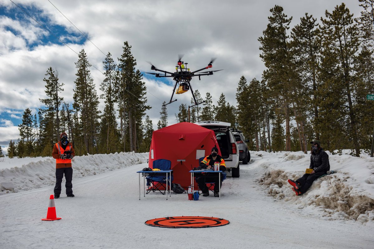
@USGS scientists recently flew #UAS under a DOI readiness waiver. #Lidar was used to estimate #SnowWaterEquivalent (SWE) near Winter Park, CO. To keep the equipment and batteries warm, we used a portable shelter + heater. How do you keep your UAS operating in extreme conditions?
Diurnal field campaign to explore vegetation water stress in Tucson, AZ with @Jeffreygillan, @GeogSaney, @ahunwx and @Wkolby using thermal and hyperspectral/lidar drones.
Journal reviewers should consider the difficulties of working in a desert :)
From our #Methods, Tools, & Technologies track:
#Drones make extensive high-resolution #imagery possible, but processing & sharing data is computationally intensive; a new paper offers a #workflow + sharing tips
#OpenAccess @Jeffreygillan @tswetnam
https://t.co/xcVzcGUSgT
Happy to share a new lab @RemoteSens_MDPI paper, "Climate and Socioeconomic Factors Drive Irrigated Agriculture Dynamics in the Lower Colorado River Basin," led by @cingularities w/ @MPDannenberg @SethMMunson @WillemJDvanLee1 others https://t.co/BHmeqt0aTY
A cool presentation about high-flow experiments from #GlenCanyonDam to move sand in #ColoradoRiver to build sandbars in #GrandCanyon was given at a meeting in Flagstaff yesterday. For info about #USGS_SBSC science in Grand Canyon sediment research: https://t.co/XTqD84LbyW.