New in @ScienceAdvances. Our paper provides a comprehensive analysis of land subsidence across Iran due to aquifer depletion, using Sentinel-1 InSAR.
#ScienceAdvancesResearch
https://t.co/Glo5YGVew5
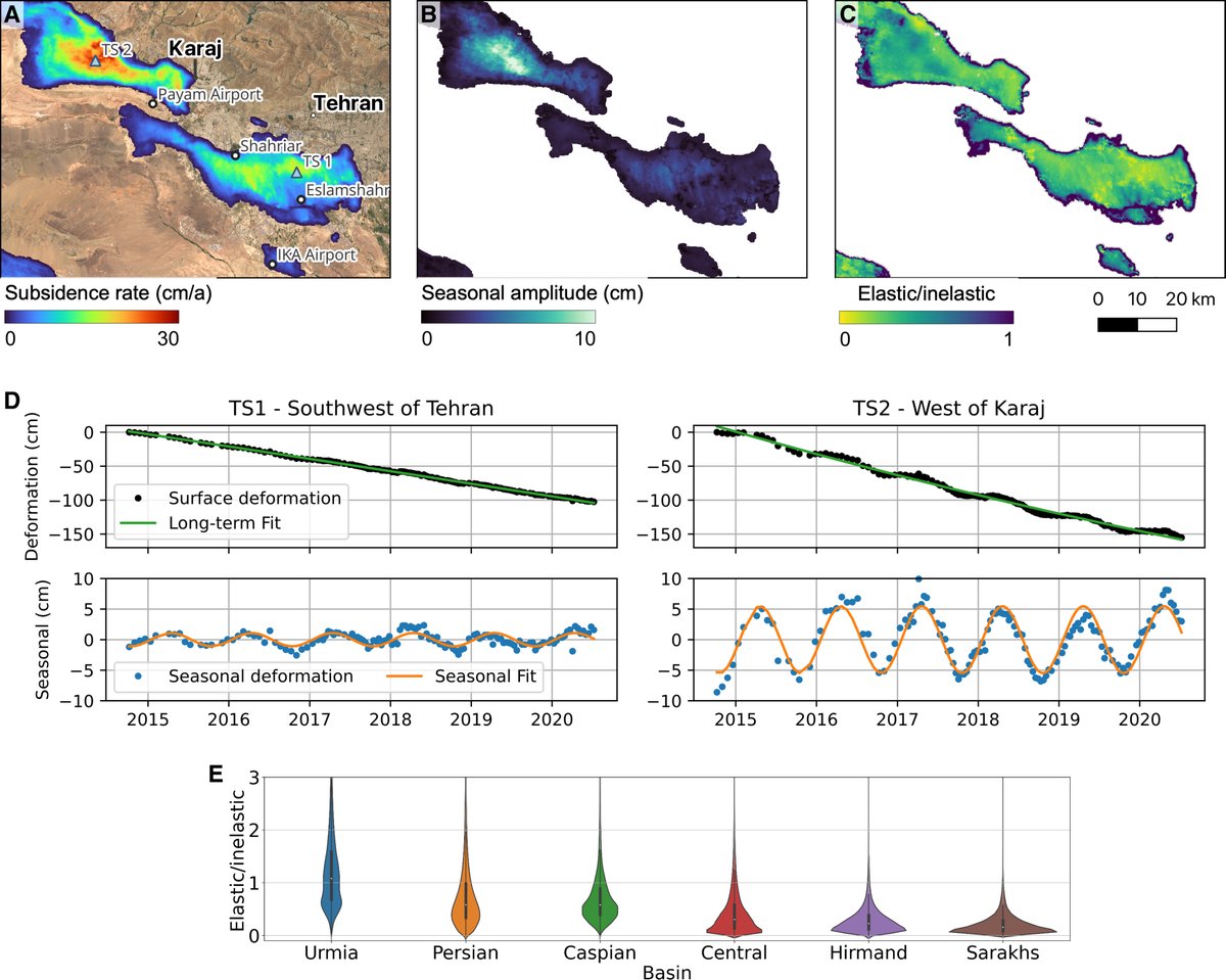
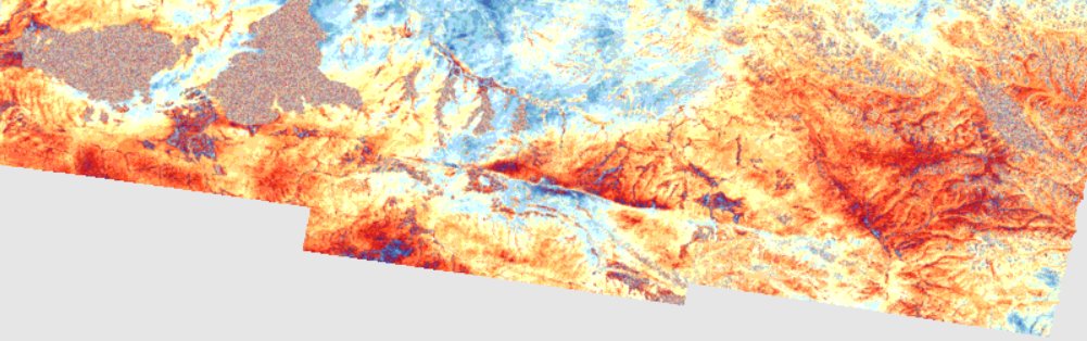
A detailed satellite survey of land subsidence in Iran from 2014 to 2020 shows that 3.5% of the country’s land area is subsiding due to groundwater pumping for irrigation. https://t.co/TqGvPPJsNL
New in @ScienceAdvances. Our paper provides a comprehensive analysis of land subsidence across Iran due to aquifer depletion, using Sentinel-1 InSAR.
#ScienceAdvancesResearch
https://t.co/Glo5YGVew5
Groundwater loss in Iran is taking on dramatic proportions. In some regions, the ground is sinking almost 40 centimeters per year & huge fissures are opening up. Click here for the news about the latest study of GFZ researcher @MahdiMotagh & his colleague https://t.co/NxNdw0j12v
Grundwasserverlust in Iran nimmt dramatische Ausmaße an. In manchen Regionen senkt sich der Boden deshalb fast 40 Zentimeter pro Jahr und riesige Erdspalten tun sich auf. Hier geht's zu der Nachricht über eine unserer neuesten Studien: https://t.co/DBnSoBXYaJ
Our findings reveal that except for Gilan, every province in Iran is experiencing land subsidence at various rates due to groundwater depletion. The nationwide subsidence data is available Access the data at https://t.co/je5gLfYxgU
Covering 2014-2020, we found 56,000 km² of Iran's land affected by subsidence, primarily due to excessive groundwater extraction for irrigation. This includes alarming subsidence rates of up to 37 cm/year, posing serious risks to infrastructure and water sustainability.
New in @ScienceAdvances. Our paper provides a comprehensive analysis of land subsidence across Iran due to aquifer depletion, using Sentinel-1 InSAR.
#ScienceAdvancesResearch
https://t.co/Glo5YGVew5
We are all set to organize our FIRST InSAR workshop at the Department of Civil Engineering, IIT Roorkee India. Stay tuned for more updates.
SALIENT FEATURES:
1. SERB sponsored
2. 25 participants (100+ applications from 50+ Indian universities)
3. 11 SAR experts
Things are starting to look serious for Sentinel-1B, which has been down since Christmas. Hopefully ESA can resolve the issues:
https://t.co/f0d1yCDBpq
Geodetic Colloquium at IGG, Uni Bonn, summer term
https://t.co/EpbOASoFAY
This Thursday 16:15 CEST=UTC+2h I will be talking about "How (Hydro-) Geodesy Monitors the Global Water Cycle – Results from @GlobalCDA, the DFG-Research Unit 2630" (in English)
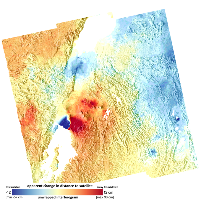
6-day S1 LiCSAR interferogram for the M7.4 Southern Qinghai earthquake - beautifully highlights shallow afterslip occurring along the fault rupture.
Links to data download from https://t.co/aXn1mUkMrQ
@COMET_database@NERC_COMET@ESA_EO
Comparing preseismic and coseismic coherence maps from Sentinel-1 clearly illustrates 170-km-long surface rupture due to Mw 7.3 Southern Qinghai, China earthquake, processed by @esa_gep
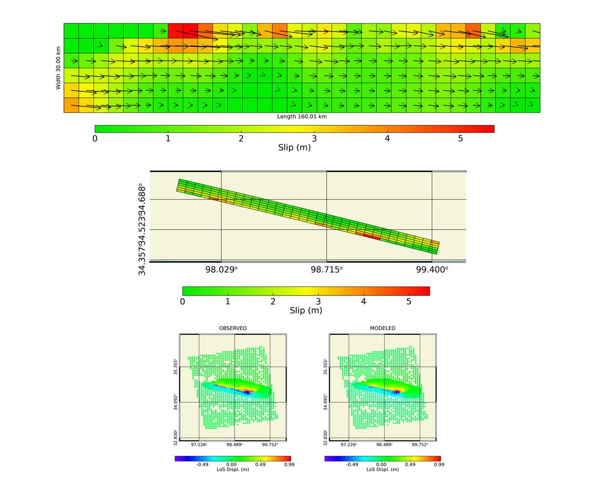
@maferp_13@CopernicusEU@FraxInSAR@claudiodeluca@EPOSeu@dott109 Just because you were curious of a quick 'n dirty model. A North dipping (strike 283°, dip 75°) nearly pure left-lateral (rake -6°) with slip up to 5 m. But high residuals by the fault trace come from unwrapping/coherence issues.
Let's join descending data.
Did we see it coming in InSAR? Well, both yes and no. The dike deformation is clear in sequences of descending (top) and ascending (bottom) S1 interferograms, but there is no short term deformation warning in the last one (up to ~14 hrs before the eruption). Adriano@CDI-KAUST
Also: Happy Spring & #Nowruz! Happy New Year to all of those who celebrate it. I hope the new year & spring bring everyone peace, prosperity, & happiness. 🧩😃🌱