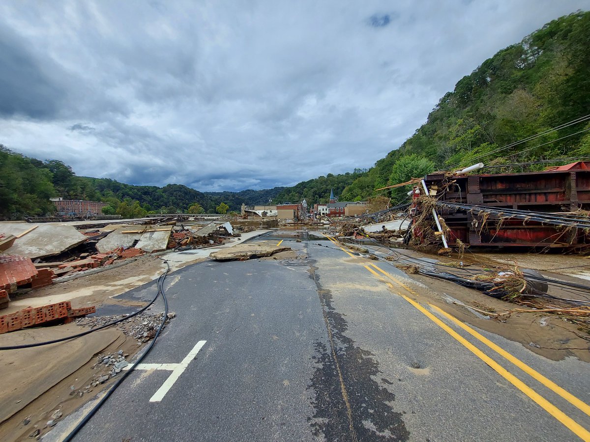
1/5 Pic thread of damage to downtown Marshall, NC along the French Broad River. I have added Google Maps image locations as references. "Pictures do not do it justice." - Jacob Golden. First entering Marshall #NCwx#Helene#Appalchians#MarshallNC
@webberweather Could not agree more! Love his videos, clear understanding of the game. Always great takes especially with the Canes. Always gives them major and rightfully deserved props along with the correct criticism when a play results in a goal against.
One of the more impressive tornado videos we've received in my time here. This from TJ Second in Union City. Looks like a strong, multi-vortex tornado. #MIWx@wwmtnews@NWSIWX
Please pray…multiple fatalities
We had a massive turnout of Samaritans helping everyone out as a community. It’s never easy to see this kind of destruction, but we dropped the chase and were able to help several people in the wreckage
Michigan strong ❤️
📍Union city, MI
Monday morning grump post.
Before you criticize, shame, and gatekeep, maybe watch the live streams of @MaxVelocityWX and @ryanhallyall first.
Whether we like it or not, this is the future of meteorology, science communication, and IDSS.
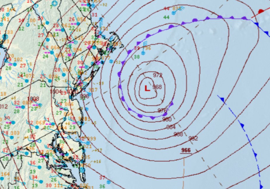
The analyzed central pressure at 7 am EST was 966 mb. This is an estimated 41 mb drop in 24 hours compared to yesterday's analysis at the same of 1007 mb.
Sunrise reveals the snow-covered landscape across the Carolinas this morning.❄️
Northwest winds are pushing cold air out over the Atlantic - leading to the expansive clouds we see from our @NOAASatellites GOES-19 satellite.🛰️
https://t.co/VyWINDk3xP
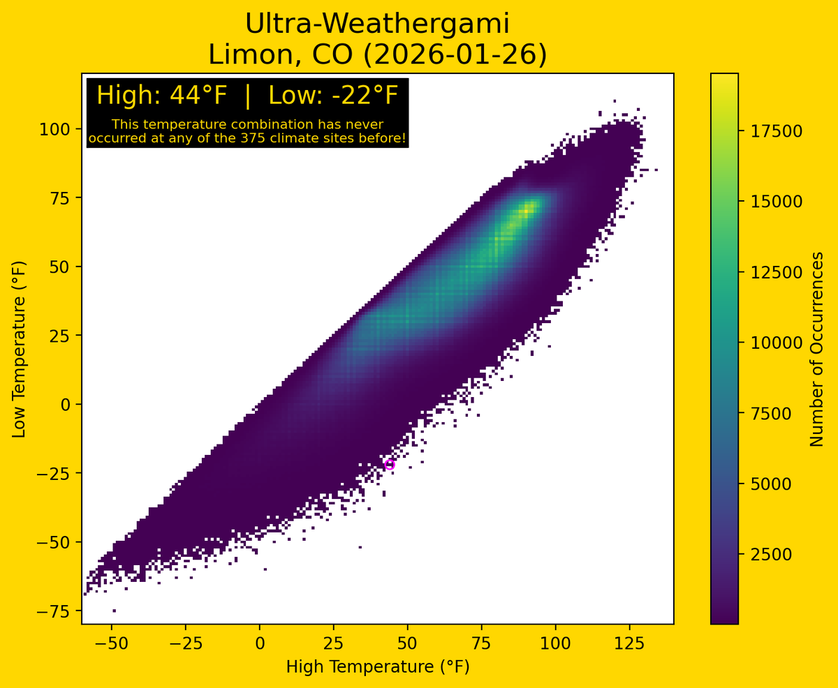
Ultra-Weathergami for Limon, CO on January 26, 2026!
With a high of 44°F and a low of -22°F, this site had a daily temperature combination not previously recorded at any of the 375 climate sites used.
There are now 8,866 unique combinations across all sites!
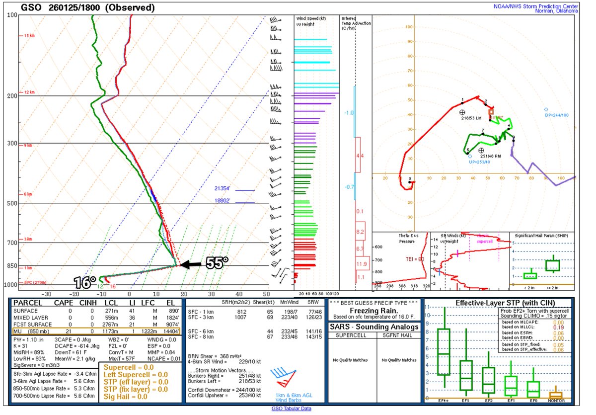
This might be an all-time sounding around here, 55° at 3280', but it's 16° at ground level. Also the 180° shift in the wind within like 200' from northeast to southwest. For laymen, this is the weather balloon at 1 pm from Greensboro, the sounding showing temperature with height. Super CAD here! #cltwx #ncwx #scwx #wcnc
The @UNCAweather program will be launching vital weather balloons throughout the storm.
The first balloon at 3 PM confirmed the existence of a shallow warm nose over AVL, thus why we’ve seen intermittent sleet this afternoon.
We’ll see how this evolves over the coming hours.
❄️During winter events where precipitation types change frequently, we rely heavily on YOUR reports!
Check out our winter page (https://t.co/4MMOhegQMt) to find multiple ways to send us your reports! You can also reply to this post! #NCwx
🚨 URGENT WEATHER ALERT: THIS IS THE REAL DEAL 🚨
Folks, I cannot stress this enough: Please prepare now!
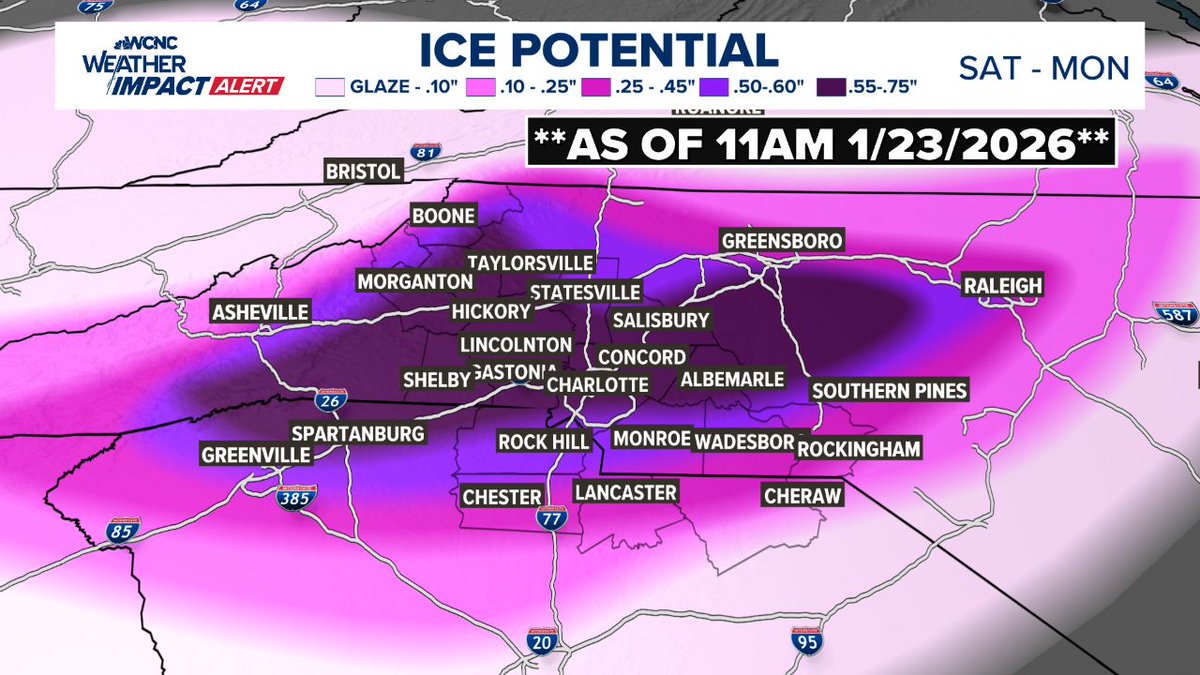
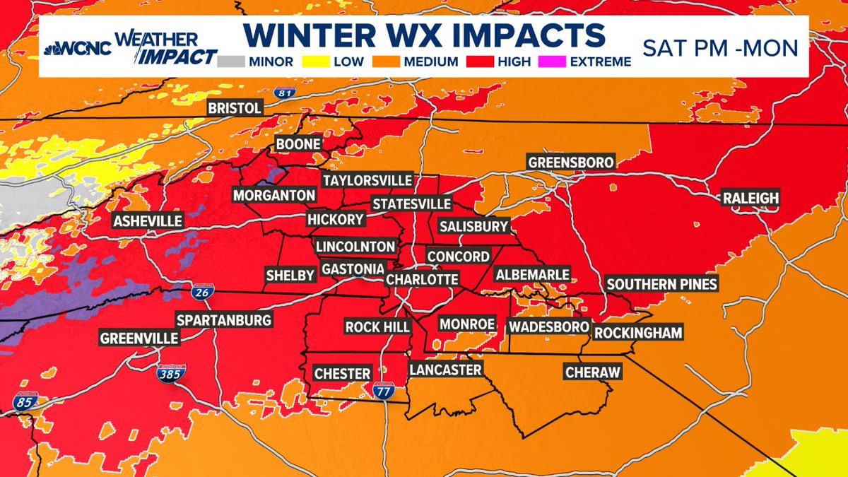
We have all day today (Friday) and most of the daylight hours on Saturday to get ready. After that, the window closes. This is not a "bread and milk" situation—this is a major to extreme ice threat. We are looking at a setup we haven't seen in at least 10 years, and if the higher ice totals hold, we could be looking at something we haven't dealt with in 20 years (think back to the 2002 ice storm).
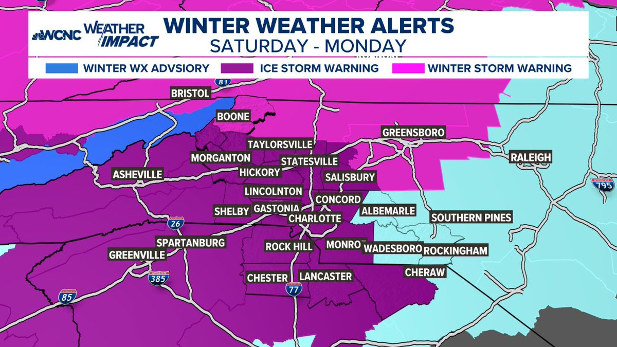
Here is the reality of what is coming this weekend (Sat PM - Monday):
🧊 THE ICE THREAT
Look at the maps attached. That pink and purple area isn't just "snow." It is freezing rain and heavy ice accumulation.
The forecast shows potential for 0.25" to 0.75" of ice.
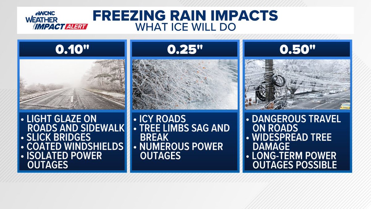
What that means: At 0.25", tree limbs snap and power lines go down. At 0.50"+ (which is possible in the darker purple bands), we are talking about widespread, long-duration power outages and impassable roads.
🛑 IMPACTS: WHAT TO EXPECT
POWER OUTAGES: This is my biggest concern. With ice accumulating on trees and lines, outages are likely. If you are in the high-risk zones, you need to be prepared to be without power for days, not hours.
TRAVEL: By Saturday night, travel will likely become dangerous to impossible. Do not plan to be on the roads Sunday. If you get stuck in an ice storm, emergency crews may not be able to reach you quickly.
TREES: The weight of the ice will bring down weak limbs and trees. If you have large trees over your driveway or home, be hyper-aware.
⏳ YOUR ACTION PLAN (DO THIS NOW):
You have until Saturday evening to get this done. Do not wait.
1. CHARGE EVERYTHING: Phones, laptops, tablets, and power banks. Do it now while the grid is 100%.
2. HEAT: If the power goes out, how will you stay warm? Have blankets ready. If you have a fireplace, get wood. **NEVER** use a generator or grill indoors—carbon monoxide is a silent killer.
3. FOOD/WATER: You don't need to panic buy, but have enough food that doesn't require cooking (sandwiches, dry goods) and water for 72 hours.
4. MEDICAL: If you need prescriptions or oxygen, secure it today.
The Bottom Line:
This isn't a "fun snow day." This is a damaging ice event. We have been lucky for a long time, but the data is showing a setup that demands respect and preparation.
Use today and tomorrow to prepare your family and check on your elderly neighbors, then stay off the roads once this starts.
Stay safe, stay warm, and stay tuned for updates.
#cltwx #ncwx #scwx #wcnc #iceOMG #icestorm #wxbrad
The NWS will be doing extra weather balloon launches from Greensboro this weekend and 1pm Sat, 1am Sun, and 1pm Sun. This is in addition to the daily 7am and 7pm launches.
Helps get better data into the models.
Ice Storm Warning now in effect for our entire forecast area, 1 PM Sat to 1 PM Mon, replacing Winter Storm Watch. Expected impacts haven't changed, but confidence has increased on significant/widespread impact mainly from freezing rain, thus the name change. #ncwx#scwx#gawx
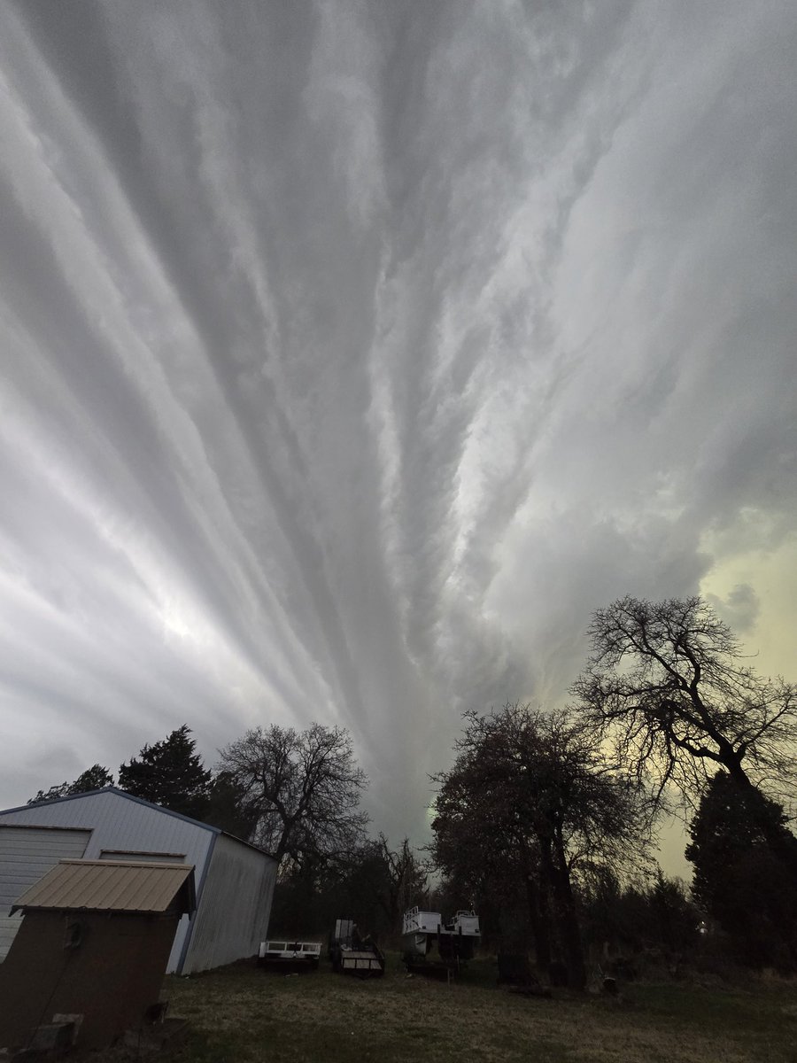
Kimberly Lewis sent a photo from Walnut Cove, NC, showing a fallstreak hole or "hole punch cloud." This occurs when a plane passes through a cloud of tiny water droplets, cooling the air enough for droplets to freeze into ice crystals. These crystals grow faster and fall out.