Too busy and you've missed our last COMET Webinar? Don't panic, now you can watch the replay anytime and anywhere https://t.co/rZDREjzCjn @TTremblingEarth
Preliminary detailed displacement from image correlation for the main fault rupture (central part) of Mw 7.1 #RidgecrestEarthquake, using imagery from Google Earth. Much detail from 2m displacement field rasters. Junction w/July 4 NE-SW rupture at the southern end.
High resolution displacement from image correlation using pre- and post- eq Google Earth images The July 4 #RidgecrestEarthquake Mw 6.4 rupture is visible in detail, up to the junction with the Mw7.1 NW-SE rupture. A lot of noise/errors but even w/ GE can identify fault features.
And the horizontal displacement results / image correlation (#MicMac) for #Ridgecrestearthquakes surface rupture, comparing pre- and post-eq high-res imagery. Profiles show coseismic offset (Not super-accurate - Imagery from GoogleEarth/DigitalGlobe@2019)
Need fault trace data for the India-Asia collision zone? Download our free (and published) datasets here: https://t.co/Kticwwq8sE
@uni_tue@toddehlers2#Quaternary
Complex and detailed pattern of co-seismic ruptures for the #RidgecrestEarthquake sequence. Red lines are primary & secondary surface ruptures, together with small triggered ruptures away from main faults. Previously mapped Quaternary Faults with yellow, for comparison.
Gradient render from unwrapped LOS displacement map (higher quality 20m from SNAP). Surface ruptures (major & minor) are easily visible as dark linear features (high displacement gradient). Processing in @esa_gep. Descending pair from #Sentinel1, #Ridgecrestearthquake
Very impressive what Nature does. Here the processed ifg @InSARinfo using @Sentinel1a data and @ESA_EO tools #SNAP. It contains the Earthquakes in South California occurred from 4th to 9th July. I counted 26 fringes. Coherence shows also some surface ruptures.
Descending interferogram #InSAR from #Sentinel1 data, #Ridgecrest#earthquake sequence. Rupture trace from previous InSAR & optical data. July 4 - July 16. Processed with DIAPASON at @esa_gep
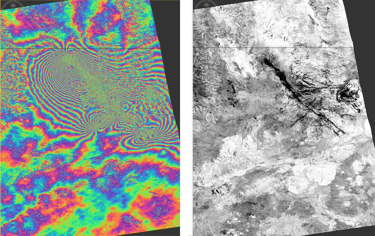
More results using @ALOS2_JAXA data available on https://t.co/SSyQaHdJYh . What really needed is the other look direction. Waiting for 16th Sentinel-1. Also check out the north west corner. That's central valley going down.
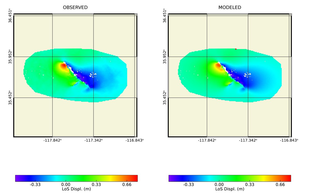
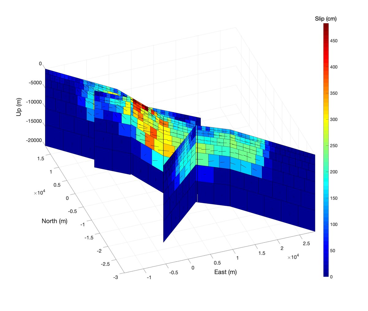
A very preliminary fault slip model for #RidgecrestEarthquake, using data from GPS, @esa Sentinel-1, @ALOS2_JAXA, optical imagery from @planetlabs by @Geo_GIF. Model, surface displacement and Coulomb stress available at https://t.co/SSyQaHdJYh.