The Amateur Radio Emergency Service® (ARES) consists of licensed amateurs who volunteer for communications duty in the public service when disaster strikes.
BREAKING: We can confirm that it was an EXPLODING METEOR that produced a sonic boom over eastern Massachusetts and much of Southern New England at 2:07 p.m. Eastern time.
It was cloudy, so there weren't reliable reports. The American Meteor Society has logged several reports of the boom.
United States Geological Survey data confirms it was NOT an earthquake.
The GOES East weather satellite has a geostationary lightning mapper that can detect infrared light emissions. At 2:07 p.m., it plotted a line of simultaneous lightning strikes in a 50 mile-long line. That would be highly unusual for lightning. While there was lightning south of Martha's Vineyard and Nantucket, this was NOT the correct region of the overall storm for lightning, nonetheless a 50 mile-long stretch of it, to occur.
As such, we are comfortable calling this an EXPLODING METEOR. The satellites detected the infrared light emissions.
A few fragments likely fell to earth, but we're reviewing additional eyewitness data and radar data to determine the exact trajectory. (If it was moving southbound as it exploded, then a spattering of fragments probably fell on the Cape.)
🫠 You don’t have to wait for a heat wave to arrive to begin protecting yourself. Here are some tips to prepare for extreme heat before the summer season begins.
For more safety tips visit https://t.co/asAP108BNk.
Check out this incredible 3D trajectory of the parachuted sensor as it completed three revolutions around the #tornado, with widet circumference with height. The sensor then sampled the “vent” at the upper reaches of the dynamic pipe. It reached velocities of at least 140 mph. This is a historic accomplishment in science and engineering by @WillClay25
Moments ago, storm chaser John McKinney witnessed this brief funnel spawned by a tornado-warned storm in far southeastern Nebraska! #NEwx
📸 @jmckinneywx1
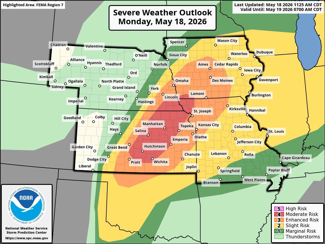
⚠️Very serious weather expected today in #IA#KS#MO#NE. All hazards possible, including tornadoes.
⛈️ CLOSELY monitor weather; conditions can change
🏠 Know your safe place day/night
📲 Have multiple ways to get alerts
🐱 Protect pets & vulnerable ppl
#iawx#kswx#mowx#newx
Noon update — a few strong tornadoes expected in northeast Kansas, especially Salina to Concordia to Manhattan.
Hail to softball size possible with stronger supercells.
Oklahoma remains uncertain.
Overnight leftovers shift into Midwest as windy line.
A focused corridor of intense supercells with possible strong tornadoes and giant hail may occur in northeast Kansas and southeast Nebraska. Other scattered storms are likely from the Great Lakes to Texas.
@MatthewCappucci has a Monday update.
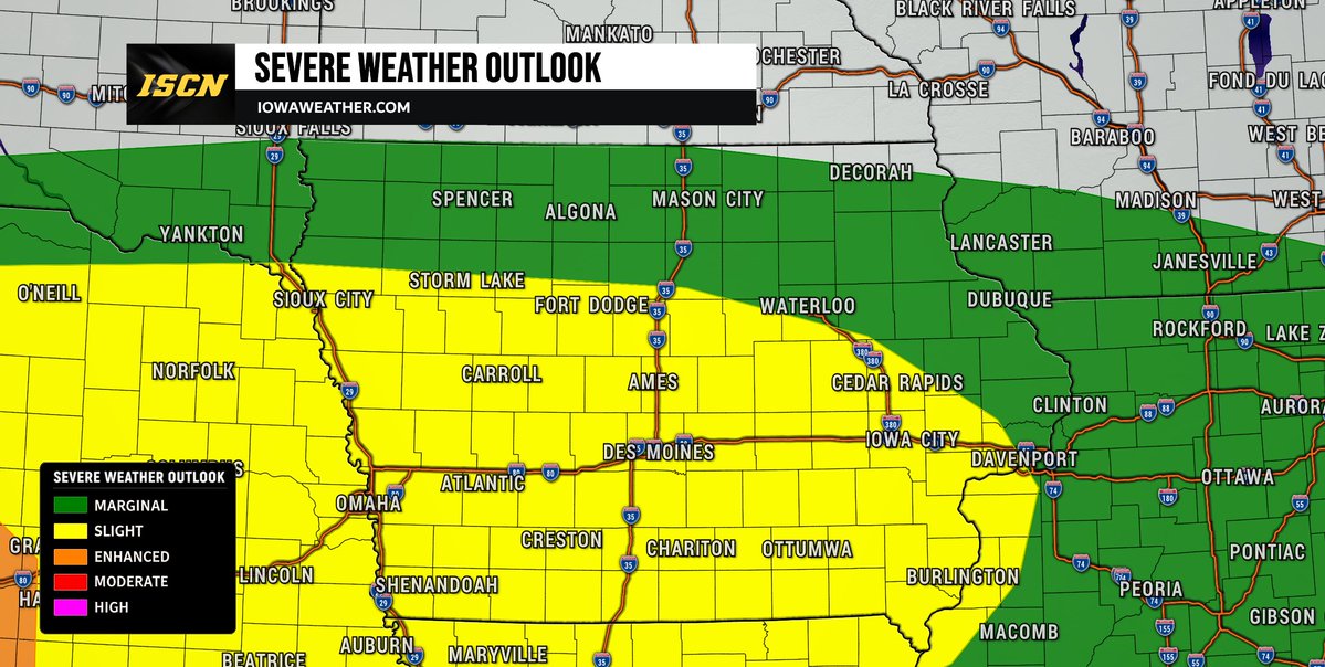
A Slight Risk (Level 2 of 5) for severe weather is in place this afternoon and tonight for areas generally along and south of Highway 20 to the Iowa/Missouri border. Warm, humid air moving into the state will create an increasingly unstable atmosphere capable of supporting severe thunderstorms through the afternoon and evening hours.
Initial storms may begin developing across central to southern Iowa after 3-4 PM and could quickly become severe with large hail, damaging wind gusts, and an isolated tornado threat. Any storms that remain isolated early on will have the greatest chance to produce tornadoes before storms are expected to merge into a larger line later this evening. Heavy rainfall will also be possible, with repeated storms capable of producing 2 to 3 inches of rain in localized areas and isolated higher totals possible.
Attention will then turn to a larger complex of storms expected to develop across southwest Nebraska into northwest Kansas this evening before tracking eastward into Iowa overnight. Current timing would bring this activity into western Iowa after 2 AM. While storms may gradually weaken as they move east, damaging winds and heavy rain could still accompany this overnight activity. This complex will then push all of the activity out of the state by mid-morning Sunday.
#iawx #iowaweather #severeweather
🚀 Mega Update for Weather Models
Today, we’re rolling out improvements across every tier, from Free to Pro.
Free:
- New Models:
- HRRRCast
- NSSL HTPO & RN
- HIRESW ARW & FV3
- HREF
- NAVGEM
- REFS (RRFS Ensemble)
- See data values under the map labels
- Personalize the model data with your own custom colortables
Plus:
- Route Planning synced with model data
- Up to 12 hours of model runs available
Pro:
- Flash a range of values to show elevated temperature, wind or reflectivity
- Glided Playback introduces buttery smooth frames
- Model Cross Section Tool
- Up to 24 hours of model runs available
Available now on:
iOS: https://t.co/rrH1bIiWUP
Android: https://t.co/lb3PumjYYE
Browser: https://t.co/16ZMjL3x1l
And to Plus/Pro subscribers using our Windows/Mac/Linux App