Are you interested in learning more about CENTAUR’s early warning system?
Join our 2nd and final Workshop on 25 February!
🗓️ Registration open until 16 February
📍 Brussels
🔗 Register here: https://t.co/2VbVGkIVKn
Join the #CENTAUR 2nd Workshop to discover the solutions we have developed over the past 3 years leveraging #EarthObservation data & AI for urban floods and food & water insecurity!
📍Brussels
🗓️25 February
⏰09:00 - 17:00 CET
🔗Register by 16 Feb here: https://t.co/2VbVGkIVKn
📢 30% of people globally who experienced a disaster received no warning. 77% of those not warned own a mobile phone – early warning systems using mobile phone technologies are essential to achieve #EarlyWarningsForAll.
World Risk Poll ➡️ https://t.co/INyAnqu6lz @LR_Foundation
Satellites alone can’t tell the full story of what’s happening in fields, and ground surveys can’t scale fast enough.
Together, they provide a real-time, reliable view of agricultural systems. See how @ESA and the @WorldBank are working to fuse both. https://t.co/oHI4vJ2xyP
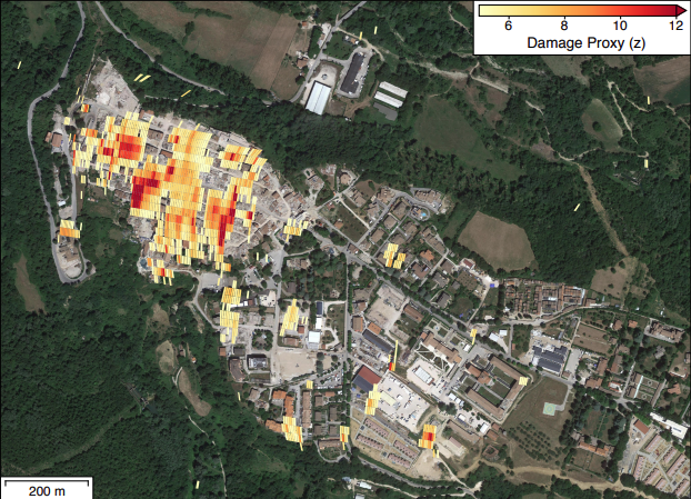
How do you measure damage in a zone you can't enter?
By teaching an AI to predict what the ground should look like, and comparing it to reality.
Here's how this satellite technique works:
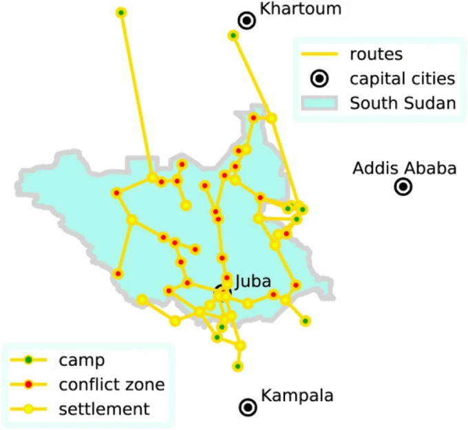
We often think refugee movements can only be tracked as they happen.
But did you know a new model can predict displacement up to several years in advance?
It uses inputs like geography, GDP, and past conflict data.
Here's how it works:
What happens when a country has no recent survey data to measure poverty? Economists turn to survey-to-survey imputation—but small modeling errors can lead to big mistakes.
A new World Bank challenge invites experts worldwide to help improve these tools.
https://t.co/YxMqiXbPTy
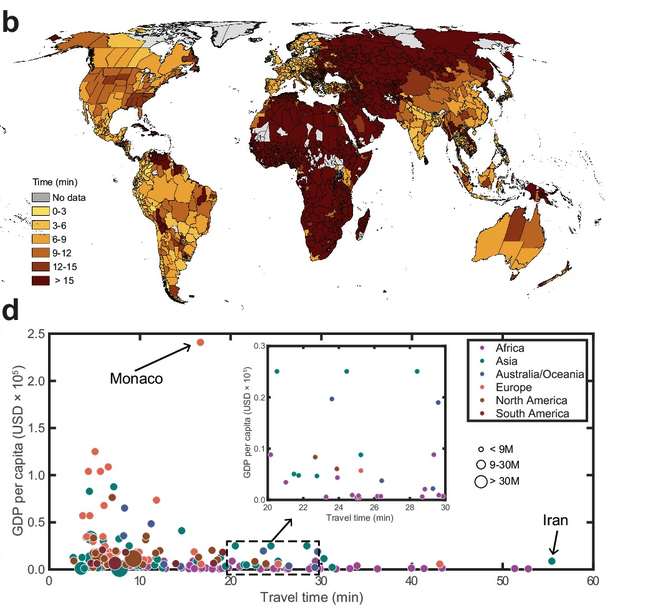
The "15 minute city" has become a buzzword in urban planning.
But how many people actually live within 15 minutes of essential services?
Researchers have now mapped this for every person on Earth.
Here's what they found:
🌍 On 4-5 November, #CENTAUR took part in the #EUSciencePreparedness Conference 2025 🇪🇺
📊 We presented research for #UrbanFlood early warning & water/food security linked to conflict and displacement🌊🌽
🔗 Read more: https://t.co/Zirl8Rd9zm
#HorizonEU
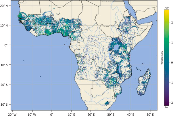
We track poverty too slowly to respond effectively.
But a new open-source tool now lets us map wealth in near real-time using satellite imagery.
Here’s what you need to know:
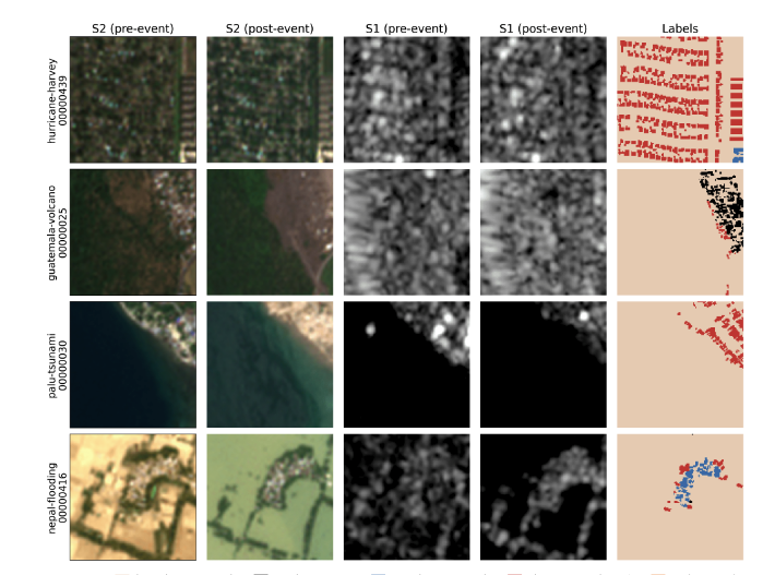
Researchers just proved that free, 10m resolution satellites can detect building damage nearly as well as expensive high-resolution imagery.
This changes disaster response.
Here's the breakdown:
For those following #ClimatePeaceSecurity at @Cop30noBrasil, our calendar of climate, peace and security-related events at/during COP will be updated regularly on the Trello managed by the #ClimateSecurityMechanism: https://t.co/xb8RNbHuEL Feel free to share event info⬇️#COP30
Most geospatial AI tools work in silos.
Now, researchers at Google have built Earth AI.
It combines foundation models for imagery, population, and environment into one reasoning engine.
Here’s the breakdown:
🌍Climate change impacts outside the EU can cascade through global systems, affecting European trade, security, and stability. A new @Nature Climate Change article by @CorneliaAuer3 and colleagues identifies this.
📖 Read a summary of the article: https://t.co/VoHSTDCO7g
#EU
#DidYouKnow that where women live can shape their access to job opportunities? Join our course to explore a new framework that incorporates location-specific factors to assess how supportive different environments are for women’s employment: https://t.co/qsRDF583DM #Ideas4Impact
❗The intersection of climate change & conflict is an urgent challenge
UN Climate, Peace & Security Advs are on the ground - assessing risks, informing policies & implementing programmes in fragile contexts
📘 New report: https://t.co/NQy00EmcKX
@UNEP@UNDPPA@UNPeacekeeping
We're constantly told how countries are run by the elites.
However, mapping the economic elite has been incredibly tough to do.
But now, a new dataset compiled by 70+ researchers provides data on over 3,500 elites in 16 countries:
A key upgrade: our World Development Indicators now feature displacement by both country of origin and asylum. This helps distinguish the burden on host countries from root causes. Data now available for 133+ countries.
Explore it here: https://t.co/z5nuNEVy8Z
Last week #CENTAUR took part in the @CopernicusEMS 4th Global Flood Forecasting & Monitoring Meeting!
We shared progress on our project, including 2⃣ indexes designed to support early warning & impact assessment for urban #floods 🌊
Read more at👇
https://t.co/WQWu4kp5Ud