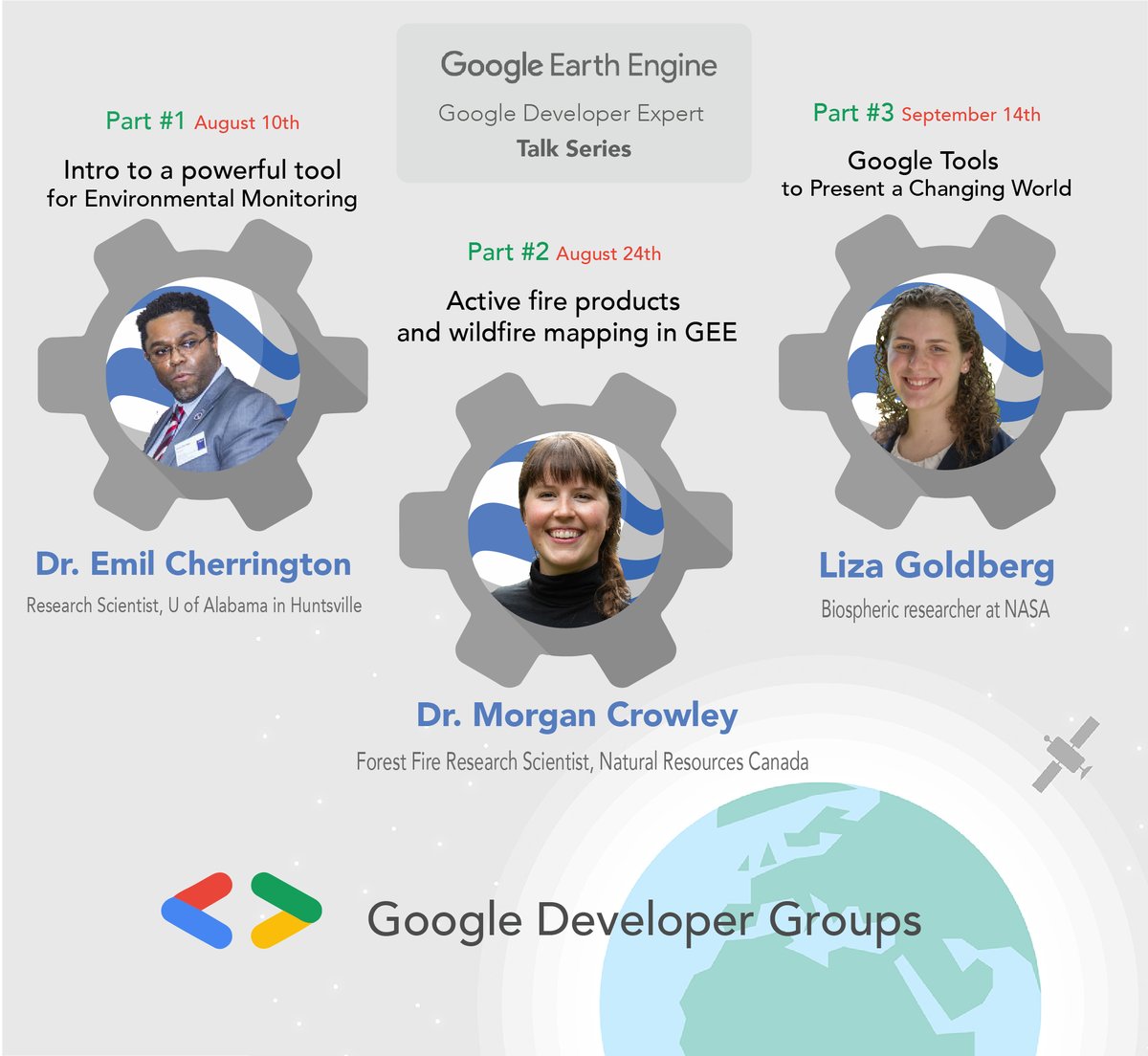
The #GEE resource you have been waiting for! #GoogleEarthEngine
Cardille et al. 2022. Cloud-Based Remote Sensing with Google Earth Engine: Fundamentals and Applications.
>100 authors (well done all!)
>55 chapters, labs, >10,000 lines of code
#OpenAccess:
https://t.co/FjzEB4OByJ
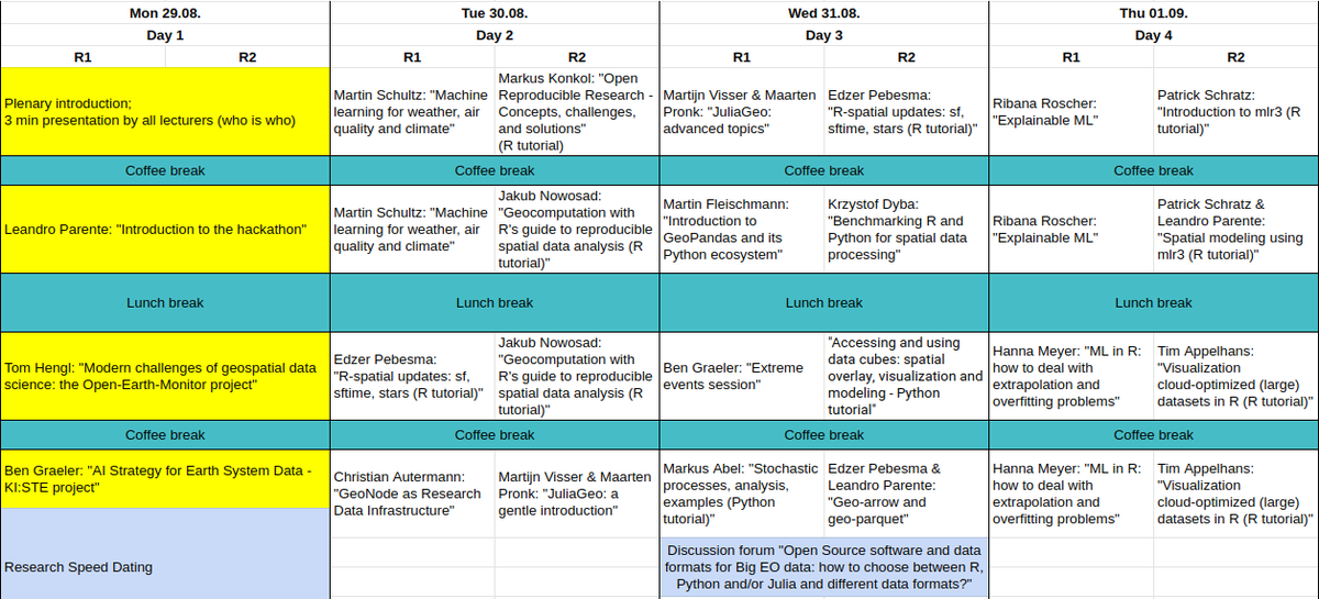
Videos of the lectures from our Summer School in Siegburg are available for watching from https://t.co/MwKxW782wy Thanx to ALL lecturers especially the @KisteProject @edzerpebesma @jakub_nowosad @hanna123987 @patscli @TimSalabim3 @FiveTwoN JuliaGeo and the @opengeohub Mediateam
Next week (28th Aug-4 Sep), the OpenGeoHub Summer School 2022 is happening! The program is packed with many #geospatial tutorials.
Importantly -- the lectures will be live-streamed at https://t.co/IvGrYvkRhY.
More info: https://t.co/5V3fLsTJNg
Share widely!
#rspatial#python
Seize the opportunity to learn about this powerful tool which has been used for watching Forest cover extension,malaria risk coverage, etc.
#EarthEngine#GeoForGood#GoogleDeveloperGroup#GoogleCloud#yeg#ab
For RVSP and more information:
https://t.co/x0fHFlNrBH
Just advertised! Research Fellow opportunity in #earthobservation with world-renowned scientists at @scienceANU , @CSIRO and @NASA to map trees from <1m #satelliteimagery across ALL of Australia - now there's a #bigdata challenge! See
https://t.co/EhcU5tDSj1
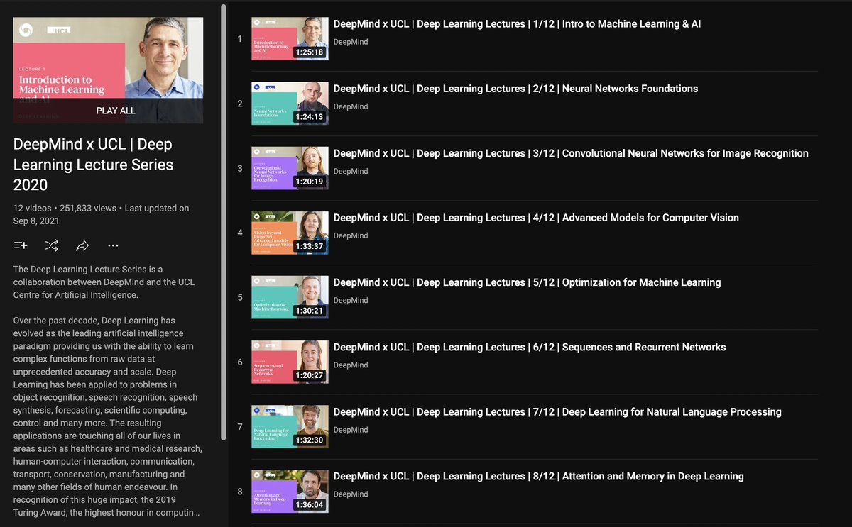
DeepMind & UCL Deep Learning Lecture Series
12 lectures on different deep learning algorithms and techniques in natural language processing, vision, generative modeling, etc...
All lectures and presentations are free and you can take them at your pace.
https://t.co/lj53ZSAlXZ
Explore new eddy-covariance processing and applications with R package authors Dominico Vitale (#Rflux), @chuhousen (#AmerifluxR), and @JurgenKnauer (#bigleaf) in our next seminar, June 22nd at 12pm PST!
>>Details and registration here:
https://t.co/AQW528N23Q
Attending #CVPR2022? Join me at:
🛰️ ML + Remote Sensing for Ag & Food Security tutorial led by me, @CLNakalembe, @_ivanzvonkov (6/20 1:30-5:30p https://t.co/y5zt1d8ViU)
🌽 AgVision workshop (6/19 https://t.co/ROOKfLjZdZ)
🌍 @EarthVisionWS workshop (6/19 https://t.co/VXfCNMjsLR)
Ever wanted to look back in time? The historical processing of the Harmonized #Landsat Sentinel-2 (#HLS) HLSL30 data is complete! The global data is available from April 2013 to the present. Learn more at NASA's #LPDAAC and download via Earthdata Search! https://t.co/AZ5Qdg9yy3
A great article for AQA A level Eco systems unit. With this diagram that hints at a feedback loops associated with peat destruction.
Peat soil fires: Campaigners say England's 'rainforests' illegally burned https://t.co/uGQCoOqWOT
Vegetation indices (VIs) are widely used, but their application and interpretation is nuanced 🛰️🌿
@mmmmchen@YeluZeng@DaleiHao@ahuete et al detail VI histories and applications in this new #TechnicalReview
https://t.co/WOxhHPsLeT
free to read https://t.co/4UHOlveh6Z
"What we do here is to serve humankind with our data", @AschbacherJosef, @esa Director General opening Living Planet Symposium 2022 #LPS22.
If you cannot join us in Bonn, follow the opening ceremony at 🔴https://t.co/yB88lBER24
🌎https://t.co/WxYQdAO9Cx
Whenever I show #QGIS editing tools to someone it blows their mind. But they can be hard to use, so I am making these mini videos on using them. Check out this new one published today. Using the Vertex Tool to Edit Geometries (QGIS Advanced Data Editing)
https://t.co/PX832bbfTc