"Seven of nine planetary boundaries now breached – ocean acidification joins the danger zone," says PIK director @jrockstrom presenting the key findings of the Planetary Health Check 2025. #PlanetaryBoundaries https://t.co/sePpqOHlIA
If @ametsoc or @nwas or @theAGU ever gave out a "Graphic of the Year" award, it should go to @jaycordeira, displaying the synoptics behind the Predecessor Rainfall Event before #Helene
It's an amazing graphic and displays our double whammy of 'rain and then more rain.'
'Apparemment', un #ouragan fonce dangereusement vers la🇫🇷& l'🇪🇺.
🌀Voyons si un ouragan comme Gabrielle, capable de ravager des régions entières des Caraïbes, peut vraiment nous frapper (ou non) & conséquences attendues chez nous. Mini thread🧵1/..
FUJIWHARA EFFECT: Can two hurricanes combine to create a super hurricane? Thankfully no! How they interact or "dance" is called the rare #Fujiwhara effect. There's a lot of buzz recently on social media about it because of the possibility between Humberto and potential Imelda. Here's a greater explainer what happens when two storms get close to one another!
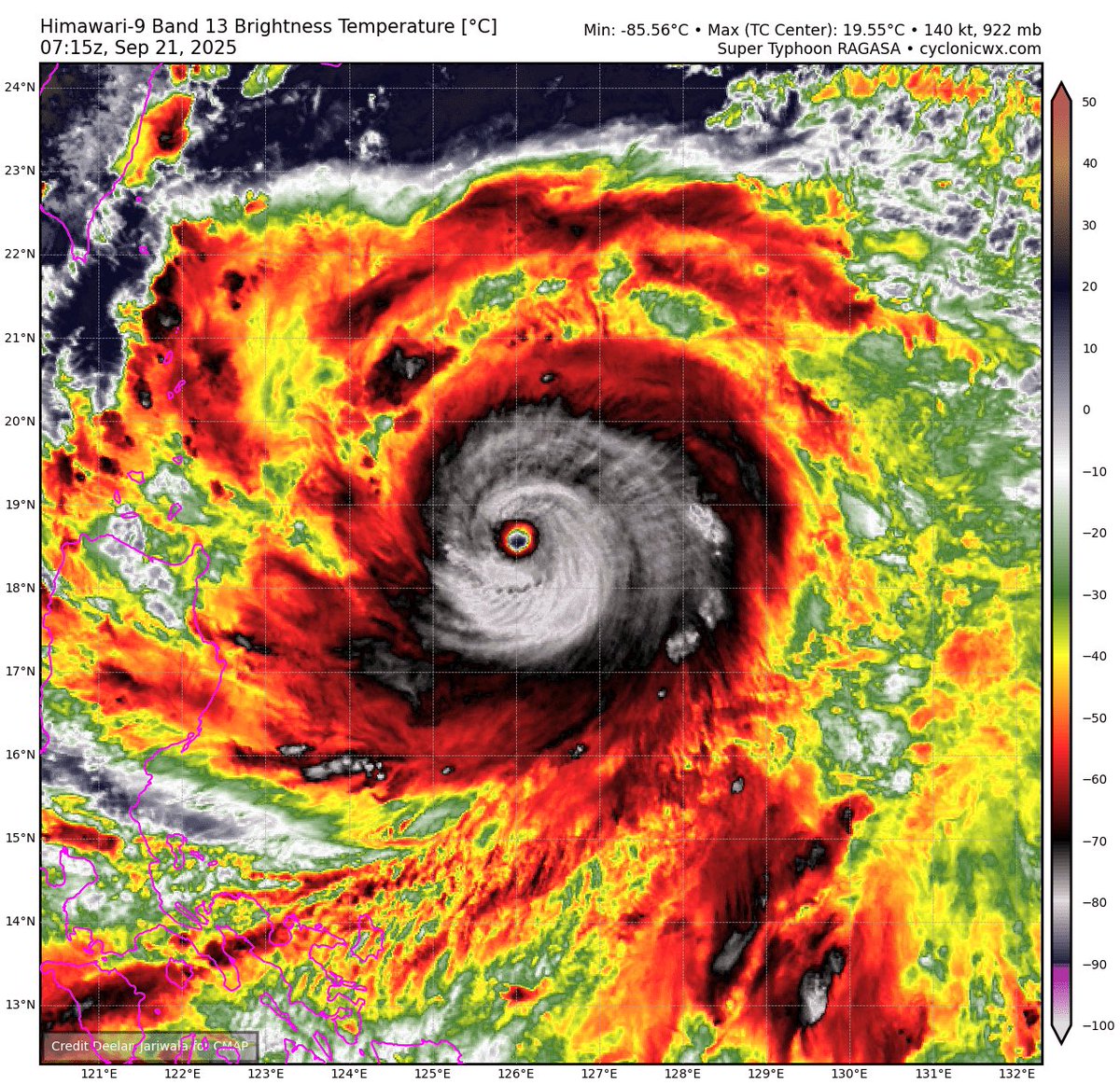
Super Typhoon Ragasa (NandoPH) is a planet-sized ice giant. A massive ring system of frozen convection orbiting a 915 MBAR atmospheric gravity well. The new eyewall is now seizing power at the core of this storm’s heat engine and is carving out an enormous eye over the Philippine Sea.
The fury of a Category 5’s whiteout is on the doorstep of the Babuyan Islands.
Typhoon #Ragasa (#NandoPH) is now making landfall in the Babayan Islands, Philippines. The last time a category 5 made landfall in this region was Chanthu in 2021 (Kiko).
Quand on revoit l'animation satellite sandwich montrant le caractère très profond de la convection hier en fin de journée, on voit que l'orage a pris une caractéristique en V avec une pointe d'alimentation bien visible en mer. Caractéristiques aussi d'un QLCS avec régénération arrière avec une ligne heureusement mobile malgré les dégâts et les inondations. S'il y avait eu un caractère plus stationnaire, ça aurait été purement catastrophique certainement.
Source animation : Meteociel
Two monsters. Both on the other side of the World.
Left: Super Typhoon #Ragasa in the West Pacific with 160 mph winds.
Right: Typhoon #Neoguri in the West Pacific winds 145 mph.
While the Atlantic tries to find its legs, the West Pacific is lit up!
NASA satellites and computers have provided us with these mesmerizing swirls that cover our planet—but this isn’t star stuff. Each color represents a different aerosol that was floating in the atmosphere above our heads from 1 August to 14 September 2024.
Depicting aerosols in this way helps us understand how far-flung corners of the globe are connected via our shared atmosphere.
Learn more in #ScienceAdviser—our free daily newsletter: https://t.co/puT6UHzhbQ